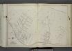
Maps of Richmond County
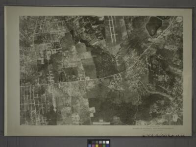
21C - N.Y. City (Aerial Set).
from Sectional aerial maps of the City of New York / [photographed and assembled under the direction of the chief engineer, July 1st, 1924].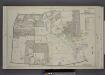
Part of Ward 1. [Map bound by Cherry Lane, Forest Ave, Lowell Ave, Davis Ave, Pelton Ave, Bard Ave, Glove Road, Richmond Turnpike, Jewett Ave]
from Atlas of the borough of Richmond, city of New York.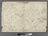
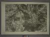
Section 7.
from Atlas of Staten Island, Richmond County, New York, from official records and surveys; compiled and drawn by F. W. Beers.
Section 12
from Atlas of Staten Island, Richmond County, New York, from official records and surveys; compiled and drawn by F. W. Beers.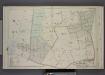
Part of Wards 1 & 2. [Map bound by Grymes Hill, Howard Ave, Woodside Ave, Centre Ave, Irving PL, Vanderbilt Ave, Richmond Road, Clove Road, Clove PL, Lakewood RD, Richmond Turnpike]
from Atlas of the borough of Richmond, city of New York.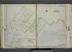
Part of Ward 1. [Map bound by Bement Ave, Harvest Ave, Revere Ave (Laurel Ave), University PL, Greenwood Ave, Forest Ave (Barrett Blvd), Reservoir North Basin, Richmond Turnpike, Clove Road]
from Atlas of the city of New York, borough of Richmond, Staten Island. From actual surveys and original plans, by George W. and Walter S. Bromley.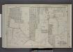
Part of Wards 2 & 3. [Map bound by Richmond Turnpike, Chestnut Ave, Todt Hill Road, Ocean Terrace, Manor Road, Egbert Ave, New Road, Willow Brook Road, Woodward Ave]
from Atlas of the borough of Richmond, city of New York.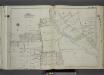
Part of Ward 1. [Map bound by Egbert Ave, Brookside Ave, Forest Ave, Clove Road, Purcell St, Raleigh Ave (Division Ave), Broadway, 1st St, Bement Ave, Britton Ave, Slosson Ave, Fairview Ave, Potter Ave, Manor Road, Marlboro PL, Palmer Ave, Wina
from Atlas of the city of New York, borough of Richmond, Staten Island. From actual surveys and original plans, by George W. and Walter S. Bromley.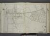
Part of Wards 1 & 2. [Map bound by Dongan Ave, Fairview Ave, Knox PL (1st St), Slosson Ave, Richmond Turnpike, Clove Road, Schoharie St, Cayuga St, Oswego St, Saratoga Ave, Little Clove Road, Ocean Terrace, Chestnut Ave, Todt Hill Ro
from Atlas of the city of New York, borough of Richmond, Staten Island. From actual surveys and original plans, by George W. and Walter S. Bromley.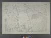
Borough of Richmond, Topographical Survey.
from Borough of Richmond, Topographical Survey.
Borough of Richmond, Topographical Survey.
from Borough of Richmond, Topographical Survey.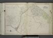
Part of Ward 2. [Map bound by Ocean Terrace, Little Clove Road, Seneca Ave, Schohaire St, Clove Road, Richmond Turnpike, Serpentine Road, Hillside Ave, Cedar Terrace, Northcote Ave, Richmond Road, Douglas Road, Emerson Drive]
from Atlas of the city of New York, borough of Richmond, Staten Island. From actual surveys and original plans, by George W. and Walter S. Bromley.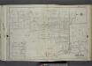
Part of Wards 1 & 2. [Map bound by Buchanan Ave, Willow Brook RD, Roosevelt Ave, Mann Ave, Gannon Ave, Byrne Ave, Richmond Turnpike, Marble St, Watchogue Road, Jewett Ave, Goodwin Ave, Winans PL, Manor Road, Portage Ave, Washington St, B
from Atlas of the city of New York, borough of Richmond, Staten Island. From actual surveys and original plans, by George W. and Walter S. Bromley.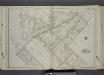
Part of Ward 1. [Map bound by Palmers Run, Spring St, Post Ave, Greenleaf Ave, Forest Ave (Cherry Lane), Brookside Ave, Egbert Ave, Manor Road, Kingsley Ave (New York Ave), New York PL, Maine Ave, Jewett Ave, College Ave (Indiana Ave)]
from Atlas of the city of New York, borough of Richmond, Staten Island. From actual surveys and original plans, by George W. and Walter S. Bromley.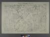
Sheet No. 31. [Includes Castleton Corners and Todt Hill.]; Borough of Richmond, Topographical Survey.
from Borough of Richmond, Topographical Survey. Staten Island. Topographical Bureau.,
Sheet No. 39.[Includes Ocean Terrace, Manor Road, Egbert Avenue, Walkers lane Todt Hill Road in Todt Hill and Dongan Hills.]; Borough of Richmond, Topographical Survey.
from Borough of Richmond, Topographical Survey. Staten Island. Topographical Bureau.,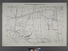
Sheet No. 30. [Includes Auburn Avenue, Willow Brook Road, Decatur Avenue, Stewart Avenue, Sheridan Avenue and Wheeler Avenue in Willow Brook.]; Borough of Richmond, Topographical Survey.
from Borough of Richmond, Topographical Survey. Staten Island. Topographical Bureau.,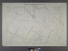
Sheet No. 38. [Includes Port Richmond Road, Manor Road, Bradley Avenue and Gun Factory Road.]; Borough of Richmond, Topographical Survey.
from Borough of Richmond, Topographical Survey. Staten Island. Topographical Bureau.,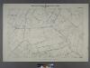
Sheet No. 46. [Includes Rockland Avenue, Forest Hill Road and port Richmond Road (Willow Brook).]; Borough of Richmond, Topographical Survey.
from Borough of Richmond, Topographical Survey. Staten Island. Topographical Bureau.,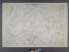
Sheet No. 47.[includes Egbert Avenue, Todt Hill Road and Dongan Hills.]; Borough of Richmond, Topographical Survey.
from Borough of Richmond, Topographical Survey. Staten Island. Topographical Bureau.,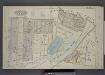
Part of Wards 1 & 2. [Map bound by Forest Ave, Brighton Ave, Castleton Ave, Woodstock St, Richmond Turnpike, Eddy St, Howard Ave, Silver Lake Park, Clove PL, Bard PL, Bard Ave, Lowell Ave]
from Atlas of the borough of Richmond, city of New York.
Borough of Richmond, Topographical Survey.
from Borough of Richmond, Topographical Survey.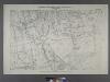
Sheet No. 16. [Includes West New Brighton (West Brighton) and (Port Richmond).]
from Borough of Richmond, Topographical Survey.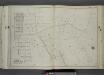
Part of Ward 2. [Map bound by Area PL, Franklin PL, Norwalk Ave, Todt Hill Road, Ocean Terrace, Redmond Ave (Fark), Benedict Ave (Atlantic Ave), New York Ave, Millard Ave, Borgert Ave, Pitt Ave, Gibson Ave, Manor Road]
from Atlas of the city of New York, borough of Richmond, Staten Island. From actual surveys and original plans, by George W. and Walter S. Bromley.
Sheet No. 32. [Includes Grymes Hill, (Emerson Hill) and Concord.]; Borough of Richmond, Topographical Survey.
from Borough of Richmond, Topographical Survey. Staten Island. Topographical Bureau.,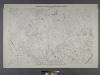
Sheet No. 40. [Includes Dongan Hills, Fingerboard Road, Richmond Road, Duncan Street, Oakdale Avenue, (Emerson Hill, Old Town)Linden Park.]; Borough of Richmond, Topographical Survey.
from Borough of Richmond, Topographical Survey. Staten Island. Topographical Bureau.,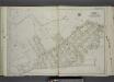
Part of Ward 2. [Map bound by Serpentine Road, Howard Ave (Serpentine RD) , Broad St, Gordon St, Tompkins St (Serpentine RD), Warren St, Pleasant PL, Vanderbilt Ave, Richmond Road, Northcole Ave, Cedar Terrace]
from Atlas of the city of New York, borough of Richmond, Staten Island. From actual surveys and original plans, by George W. and Walter S. Bromley.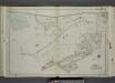
Part of Ward 2. [Map bound by Richmond Turnpike, Austin PL, Occident Ave, St. Pauls Ave, Stone St, Targee St, Purroy St (Elm St), Gordon St, Broad St, Howard Ave (Serpentine RD), Eddy St, Duncan Ave, Thressea PL]
from Atlas of the city of New York, borough of Richmond, Staten Island. From actual surveys and original plans, by George W. and Walter S. Bromley.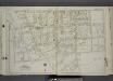
Part of Ward 1. [Map bound by Castleton Ave, N. Burgher Ave (Burgher), Cary Ave, Bement Ave, John T. Barrett Hrs., Broadway, Raleigh (Division Ave) Ave, Freeman PL, Purcell St, Clove Road (Brooks Ave) (Columbia St), Forest Ave (Cherry L
from Atlas of the city of New York, borough of Richmond, Staten Island. From actual surveys and original plans, by George W. and Walter S. Bromley.