Maps of Kings County

Brooklyn V. 15, Plate No. 1 [Map bounded by Flatbush Ave., Farragut Rd., Nostrand Ave., Glenwood Rd.]
From Atlas 101. Vol. 15, 1907.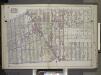
Brooklyn, Vol. 2, Double Page Plate No. 7; Part of Wards 29, 31 & 32, Sections 15 & 16; [Map bounded by Dorchester Road, Clarendon Road; Including E. 37th St., Glenwood Road, Avenue G, E. 17th St.] / by and under the direction of Hugo Ullitz.
From Volume 2.
Part of Wards 29, 30, 31 & 32, Land Map Section, No. 16. Volume 2, Brooklyn Borough, New York City.
from Atlas of the Brooklyn borough of the City of New York : originally Kings Co.; complete in three volumes ... based upon official maps and plans ... / by and under the supervision of Hugo Ullitz, C.E.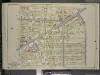
Brooklyn, Vol. 5, Double Page Plate No. 18; Part of Wards 29 & 32, Section 16; [Map bounded by E. 29th St., Avenue G, Kenmore Pl.; Including E. 21st St., Ditmas Ave., Avenue D]
from Ward 29 and part of 32.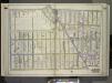
Brooklyn, Vol. 3, Double Page Plate No. 2; Part of Ward 32, Section 23; [Map bounded by Glenwood Road, E. 14th St., Avenue K; Including Flatbush Ave., Ocean Ave.] / by and under the direction of Hugo Ullitz.
From Volume 3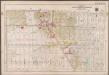
Plate 22: [Bounded by (Vanderveer Park) Farragut Road, Paerdegat Avenue, E. 42nd Street, Avenue J. and Ocean Avenue.]; Atlas of the borough of Brooklyn, city of New York: from actual surveys and official plans by George W. and Walter S. Bromley.
from Atlas of the borough of Brooklyn, city of New York : from actual surveys and official plans by George W. and Walter S. Bromley. G.W. Bromley & Co.,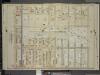
Brooklyn, Vol. 5, Double Page Plate No. 13; Part of Wards 29 & 32, Section 16; [Map bounded by Avenue D, E. 40th St.; Including Glenwood Road, E. 29th St.]
from Ward 29 and part of 32.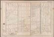
Plate 23:[Bounded by Avenue I., Ocean Avenue, Cedar Avenue, Bay Avenue, Elm Avenue, Coney Island Avenue, Avenue M. and Gravesend Avenue.]; Atlas of the borough of Brooklyn, city of New York: from actual surveys and official plans by George W. and Walter S. Bromley.
from Atlas of the borough of Brooklyn, city of New York : from actual surveys and official plans by George W. and Walter S. Bromley. G.W. Bromley & Co.,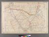
Plate 25: [Bounded by Avenue C, Ralph Avenue, Avenue L, Ocean Avenue, Avenue E, Avenue D and E. 31st Street.
from Robinson's atlas of Kings County, New York : compiled from official records ... / under the direction of E. Robinson.
23A - N.Y. City (Aerial Set).
from Sectional aerial maps of the City of New York / [photographed and assembled under the direction of the chief engineer, July 1st, 1924].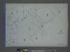
Area District Map Section No. 23; Area district map / City of New York, Board of Estimate and Apportionment.
from Area district map / City of New York, Board of Estimate and Apportionment. New York (N.Y.). Board of Estimate and Apportionment,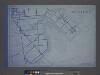
Use District Map Section No. 23; Use district map / City of New York, Board of Estimate and Apportionment.
from Use district map / City of New York, Board of Estimate and Apportionment. New York (N.Y.). Board of Estimate and Apportionment,
Height District Map Section No. 23; Height district map / City of New York, Board of Estimate and Apportionment.
from Height district map / City of New York, Board of Estimate and Apportionment. New York (N.Y.). Board of Estimate and Apportionment,
Plan of the city of Brooklyn, L.I. / by William Perris.
from Brooklyn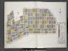
Key
From Atlas 92. Vol. 10, 1905.
Insurance Maps of the Brooklyn city of New York Volume Seven. Published by the Sanborn map co. 117, Broadway, New York. 1888.
From Atlas 83. Vol. 7, 1888.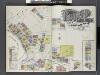
Insurance Maps of Brooklyn New York Sanborn Perris map co. 113 Broadway, New York. Volume "B" 1895.
From Atlas 62. Vol. B, 1895.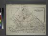
Gravesend. Kings Co. L.I.
from Atlas of Long Island, New York. From recent and actual surveys and records.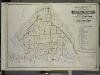
Index to Volume Seven. Atlas of the Borough of Brooklyn. Sections 20, 21 & 22. Ward 31. City of New York. E. Belcher Hyde, 97 Liberty St., Brooklyn Borough. 1907.
from Ward 31.
East Astoria, part of Long Island City, Queens Co.
from Atlas of Long Island, New York. From recent and actual surveys and records.
Flatlands. Kings Co. L.I.
From Atlas of Long Island, New York. From recent and actual surveys and records.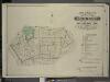
Index to Volume Five. Atlas of the Borough of Brooklyn. Sections 15 & 16. Ward 29 and part of 32. City of New York. E. Belcher Hyde, 97 Liberty St., Brooklyn Borough. 1906.
from Ward 29 and part of 32.
Topographical map of the city of Brooklyn as reduced from the original maps on file showing farm lines, modern improvements, etc.
From Brooklyn
Brooklyn
1 : 24000
Brooklyn
1 : 24000
Brooklyn
1 : 24000
Brooklyn
1 : 24000
Brooklyn
1 : 24000
Brooklyn
1 : 24000
Brooklyn
1 : 24000
![Brooklyn V. 15, Plate No. 1 [Map bounded by Flatbush Ave., Farragut Rd., Nostrand Ave., Glenwood Rd.]](https://images-1.georeferencer.com/images/iiif/786828492873/full/,300/0/native.jpg)

