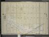
Maps of Kings County
Area District Map Section No. 23; Area district map / City of New York, Board of Estimate and Apportionment.
from Area district map / City of New York, Board of Estimate and Apportionment. New York (N.Y.). Board of Estimate and Apportionment,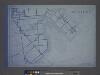
Use District Map Section No. 23; Use district map / City of New York, Board of Estimate and Apportionment.
from Use district map / City of New York, Board of Estimate and Apportionment. New York (N.Y.). Board of Estimate and Apportionment,
Height District Map Section No. 23; Height district map / City of New York, Board of Estimate and Apportionment.
from Height district map / City of New York, Board of Estimate and Apportionment. New York (N.Y.). Board of Estimate and Apportionment,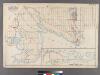
Plate 31: [Bounded by Avenue K, E. 103rd Street, Avenue N, E. 98th Street, (Bulkhead Line) Denton Avenue, (Paerdegat Basin) Paerdegat Avenue, E. 76th Street, Avenue Y, (Bulkhead Line) E. 69th Street, Avenue T and Ralph Avenue.]
from Robinson's atlas of Kings County, New York : compiled from official records ... / under the direction of E. Robinson.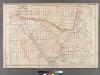
Plate 25: [Bounded by Avenue C, Ralph Avenue, Avenue L, Ocean Avenue, Avenue E, Avenue D and E. 31st Street.
from Robinson's atlas of Kings County, New York : compiled from official records ... / under the direction of E. Robinson.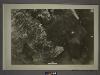
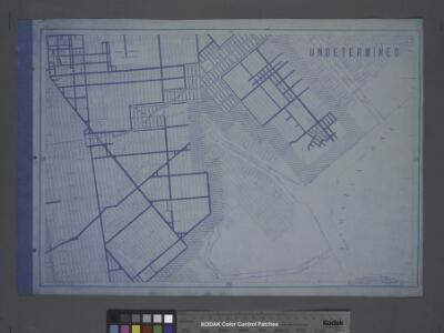
23B - N.Y. City (Aerial Set).
from Sectional aerial maps of the City of New York / [photographed and assembled under the direction of the chief engineer, July 1st, 1924].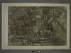
23A - N.Y. City (Aerial Set).
from Sectional aerial maps of the City of New York / [photographed and assembled under the direction of the chief engineer, July 1st, 1924].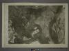
23D - N.Y. City (Aerial Set).
from Sectional aerial maps of the City of New York / [photographed and assembled under the direction of the chief engineer, July 1st, 1924].
Canarsie. Town of Flat Lands, Kings Co.
from Atlas of Long Island, New York. From recent and actual surveys and records.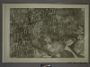
23C - N.Y. City (Aerial Set).
from Sectional aerial maps of the City of New York / [photographed and assembled under the direction of the chief engineer, July 1st, 1924].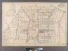
Plate 30: [Bounded by Ditmas Avenue, E. 98th Street, Spofford Avenue, Avenue D, E. 106th Street, Avenue K and Paerdegat Avenue.]
from Robinson's atlas of Kings County, New York : compiled from official records ... / under the direction of E. Robinson.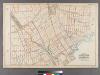
Plate 26: [Bounded by Avenue L. Ralph Avenue, E. 61st Street, Avenue U, Ryder Street, Avenue W, E. 33rd Street, Avenue V, Burnett Street, Avenue U, Gerritsen Avenue, Avenue U and Ocean Avenue.]
from Robinson's atlas of Kings County, New York : compiled from official records ... / under the direction of E. Robinson.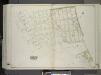
Brooklyn, Vol. 3, Double Page Plate No. 36; Part of Ward 32, Section 24; [Map bounded by Avenue L, Canarsie Ave.; Including E. 93rd St., Jamaica Bay, Paerdegat Basin] / by and under the direction of Hugo Ullitz.
From Volume 3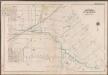
Plate 36:[Bounded by Avenue D., Ralph Avenue, Avenue D., E. 84th Street, Avenue L., E. 82nd Street, Skidmore Avenue, Paerdegat Avenue, Avenue L., E. 70th Street, Avenue K., E. 55th Street, Avenue J., E. 42nd Street, Foster Avenue and E. 40th Street.]; Atlas of the borough of Brooklyn, city of New York: from actual surveys and official plans by George W. and Walter S. Bromley.
from Atlas of the borough of Brooklyn, city of New York : from actual surveys and official plans by George W. and Walter S. Bromley. G.W. Bromley & Co.,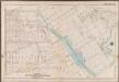
Plate 32: [Bounded by Avenue P., E. 31st Street, Avenue Q., E. 34th Street, Avenue R., Kimball Street, Fillmore Avenue, E. 55th Street, Lay Avenue, Flatbush Avenue, Avenue U., Ryder Street, Avenue X., E. 30th Street, Avenue W., Knapp Street, Avenue V. and Ocean Avenue.]; Atlas of the borough of Brooklyn, city of New York: from actual surveys and official plans by George W. and Walter S. Bromley.
from Atlas of the borough of Brooklyn, city of New York : from actual surveys and official plans by George W. and Walter S. Bromley. G.W. Bromley & Co.,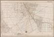
Plate 33: [Bounded by Avenue J., E. 56th Street, Fillmore Avenue, Kimball Street, Avenue R., E. 35th Street, Avenue Q., E. 31st Street, Avenue P. and Ocean Avenue.]; Atlas of the borough of Brooklyn, city of New York: from actual surveys and official plans by George W. and Walter S. Bromley.
from Atlas of the borough of Brooklyn, city of New York : from actual surveys and official plans by George W. and Walter S. Bromley. G.W. Bromley & Co.,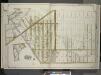
Brooklyn, Vol. 3, Double Page Plate No. 4; Part of Ward 32, Section 23; [Map bounded by Avenue K, Ralph Ave., Avenue O, Flatbush Ave.; Including Flatlands Ave., E. 37th St., Avenue E, E. 38th St., Hubbard PL., E. 40th St.]; Sub Plan; [Map bounded by A...
From Volume 3
Plate 38: [Bounded by Avenue K., Ralph Avenue, Avenue K., E. 70th Street, Avenue L., E. 75th Street, Avenue M., Skidmore Avenue, E. 83rd Street, Denton Avenue, E. 80th Street, [...] Avenue N., E. 76th Street, Avenue Y., E. 69th Street, Avenue T., E. 65th Street, Avenue U., E. 54th Street, Avenue T. and E. 55th Street.]; Atlas of the borough of Brooklyn, city of New York: from actual surveys and official plans by George W. and Walter S. Bromley.
from Atlas of the borough of Brooklyn, city of New York : from actual surveys and official plans by George W. and Walter S. Bromley. G.W. Bromley & Co.,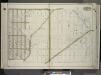
Brooklyn, Vol. 3, Double Page Plate No. 3; Part of Ward 32, Sections 23 & 24; [Map bounded by Glenwood Road, Paerdegat Ave., Ralph Ave.; Including Avenue K, E. 40th St.] / by and under the direction of Hugo Ullitz.
From Volume 3
Double Page Plate No. 5: [Bounded by Avenue D, East 53rd Street, Avenue E, East 52nd Street, Avenue F, East 51st Street, Paerdegat Avenue, Utica Avenue, Avenue G and Nostrand Avenue.]
from Atlas of the Brooklyn borough of the City of New York : originally Kings Co.; complete in three volumes ... based upon official maps and plans ... / by and under the supervision of Hugo Ullitz, C.E.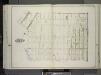
Brooklyn, Vol. 3, Double Page Plate No. 24; Part of Wards 31-32, Sections 23-24; [Map bounded by Flatlands Ave., Flatbush Ave., Fillmore Ave.; Including Burnett St., Avenue P, E. 27th St.] / by and under the direction of Hugo Ullitz.
From Volume 3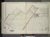
Brooklyn, Vol. 3, Double Page Plate No. 31; Part of Wards 29-32, Section 24; [Map bounded by Avenue D, E. 57th St., Beverley Rd., Remsen Ave.; Including Farragut Rd., Glenwood Rd., Utica Ave., E. 51st St.] / by and under the direction of Hugo Ullitz.
From Volume 3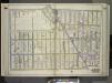
Brooklyn, Vol. 3, Double Page Plate No. 2; Part of Ward 32, Section 23; [Map bounded by Glenwood Road, E. 14th St., Avenue K; Including Flatbush Ave., Ocean Ave.] / by and under the direction of Hugo Ullitz.
From Volume 3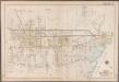
Plate 37: [Bounded by E. 103rd Street, Avenue M., E. 104th Street, Avenue N., E. 98th Street, Skidmore Avenue, E. 96th Street, Canarsie Road Avenue, Schenck Avenue, E. 92nd Street, Denton Avenue, E. 93rd Street, Seaview Avenue, Skidmore Avenue, E. 82nd Street, Avenue L., E. 84th Street and Foster Avenue.]; Atlas of the borough of Brooklyn, city of New York: from actual surveys and official plans by George W. and Walter S. Bromley.
from Atlas of the borough of Brooklyn, city of New York : from actual surveys and official plans by George W. and Walter S. Bromley. G.W. Bromley & Co.,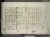
Brooklyn, Vol. 3, Double Page Plate No. 33; Part of Ward 32, Section 24; [Map bounded by Farragut Rd., Louisiana Ave.; Including Avenue K, E. 92nd St.] / by and under the direction of Hugo Ullitz.
From Volume 3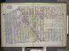
Brooklyn, Vol. 2, Double Page Plate No. 7; Part of Wards 29, 31 & 32, Sections 15 & 16; [Map bounded by Dorchester Road, Clarendon Road; Including E. 37th St., Glenwood Road, Avenue G, E. 17th St.] / by and under the direction of Hugo Ullitz.
From Volume 2.
Part of the Town of Flatbush, Kings Co., N.Y.
from Robinson's atlas of Kings County, New York : compiled from official records ... / under the direction of E. Robinson.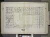
Brooklyn, Vol. 2, Double Page Plate No. 5; Part of Ward 29, Section 15; [Map bounded by Church Ave., E. 52nd St.; Including Clarendon Road, New York Ave.] / by and under the direction of Hugo Ullitz.
From Volume 2.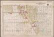
Plate 22: [Bounded by (Vanderveer Park) Farragut Road, Paerdegat Avenue, E. 42nd Street, Avenue J. and Ocean Avenue.]; Atlas of the borough of Brooklyn, city of New York: from actual surveys and official plans by George W. and Walter S. Bromley.
from Atlas of the borough of Brooklyn, city of New York : from actual surveys and official plans by George W. and Walter S. Bromley. G.W. Bromley & Co.,