Maps of Kings County

Brooklyn V. 11, Plate No. 86 [Map bounded by 64th St., 9th Ave., Bay Ridge Ave., 8th Ave.]
From Atlas 95. Vol. 11, 1905.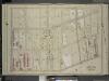
Brooklyn, Vol. 6, Double Page Plate No. 10; Part of Ward 30, Section 18; [Map bounded by 8th Ave., 72nd St.; Including 5th Ave., 60th St.]
from Ward 30.
Brooklyn, Vol. 6, Double Page Plate No. 9; Part of Ward 30, Section 17; [Map bounded by 58th St., 12th Ave.; Including 67th St., 8th Ave.]
from Ward 30.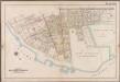
Plate 10: [Bounded by 85th Street, 1st Avenue, 86th Street, 2nd Avenue, 87th Street, 3rd Avenue., 88th Street, 5th Avenue, 86th Street, New Utrecht Avenue, Atlantic Avenue, (Dyker Beach Park) 7th Avenue, Warehouse Avenue, Cropsey Avenue, Dahlgreen Place, 92nd Street, ((Fort Hamilton) Fort Hamilton Avenue, Denyse Street, 5th Avenue and Bay Ridge Parkway.]; Atlas of the borough of Brooklyn, city of New York: from actual surveys and official plans by George W. and Walter S. Bromley.
from Atlas of the borough of Brooklyn, city of New York : from actual surveys and official plans by George W. and Walter S. Bromley. G.W. Bromley & Co.,
Part of Ward 30, Land Map Sections, Nos. 17, 18 & 19. Volume 2, Brooklyn Borough, New York City.
from Atlas of the Brooklyn borough of the City of New York : originally Kings Co.; complete in three volumes ... based upon official maps and plans ... / by and under the supervision of Hugo Ullitz, C.E.
Part of Ward 30, Land Map Sections, Nos. 3, 17 & 18, Volume 2, Brooklyn Borough, New York City.
from Atlas of the Brooklyn borough of the City of New York : originally Kings Co.; complete in three volumes ... based upon official maps and plans ... / by and under the supervision of Hugo Ullitz, C.E.
Plate 11: [Bounded by 58th Street, Fourteenth Avenue, 72nd Street, Stewart Avenue Cowenhoven Lane and Seventh Avenue.]
from Robinson's atlas of Kings County, New York : compiled from official records ... / under the direction of E. Robinson.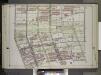
Brooklyn, Vol. 2, Double Page Plate No. 18; Part of Ward 30, Section 18; [Map bounded by 60th St., 8th Ave., 74th St.; Including Ridge Blvd., 2nd Ave.] / by and under the direction of Hugo Ullitz.
From Volume 2.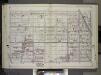
Brooklyn, Vol. 2, Double Page Plate No. 17; Part of Ward 30, Sections 17, 18 & 19; [Map bounded by 61st St., 15th Ave., 74th St.; Including 7th Ave., 8th Ave.] / by and under the direction of Hugo Ullitz.
From Volume 2.
Part of Ward 30, Land Map Section, No. 18. Volume 2, Brooklyn Borough, New York City.
from Atlas of the Brooklyn borough of the City of New York : originally Kings Co.; complete in three volumes ... based upon official maps and plans ... / by and under the supervision of Hugo Ullitz, C.E.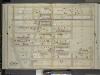
Brooklyn, Vol. 6, Double Page Plate No. 16; Part of Ward 30, Sections 17, 18 & 19; [Map bounded by 67th St., 12th Ave., 76th St.; Including 7th Ave., 8th Ave.]
from Ward 30.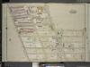
Brooklyn, Vol. 6, Double Page Plate No. 15; Part of Ward 30, Section 18; [Map bounded by 72nd St., 7th Ave.; Including 10th Ave., 81st St., 5th Ave.]
from Ward 30.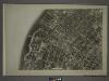
22A - N.Y. City (Aerial Set).
from Sectional aerial maps of the City of New York / [photographed and assembled under the direction of the chief engineer, July 1st, 1924].
Plan of the city of Brooklyn, L.I. / by William Perris.
from Brooklyn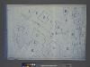
Area District Map Section No. 22; Area district map / City of New York, Board of Estimate and Apportionment.
from Area district map / City of New York, Board of Estimate and Apportionment. New York (N.Y.). Board of Estimate and Apportionment,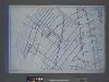
Use District Map Section No. 22; Use district map / City of New York, Board of Estimate and Apportionment.
from Use district map / City of New York, Board of Estimate and Apportionment. New York (N.Y.). Board of Estimate and Apportionment,
Height District Map Section No. 22; Height district map / City of New York, Board of Estimate and Apportionment.
from Height district map / City of New York, Board of Estimate and Apportionment. New York (N.Y.). Board of Estimate and Apportionment,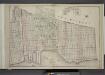
Brooklyn, Double Page Section 6; [Including Wards 8, 22]
from Farm line map of the city of Brooklyn, from official records and surveys; comp. and drawn by Henry Fulton.
Key
From Atlas 95. Vol. 11, 1905.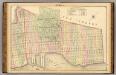
Sec. 6. Brooklyn map.
1 : 6000 Fulton, Henry; J.B. Beers & Co.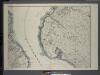
General map of the borough of Richmond (Staten Island) in the city of New York : showing in addition to the existing topographical features of the borough a tentative and preliminary plan for a street system of the same.
from Staten Island
Coney Island, Gravesend, Sea Gate. (cont.)
From District 13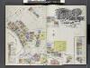
Insurance Maps of Brooklyn New York Sanborn Perris map co. 113 Broadway, New York. Volume "B" 1895.
From Atlas 62. Vol. B, 1895.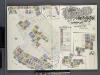
Insurance Maps of Brooklyn New York Sanborn Perris map co. 113, Broadway, New York. Volume "A" 1893.
From Atlas 61. Vol. A, 1893.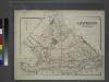
Gravesend. Kings Co. L.I.
from Atlas of Long Island, New York. From recent and actual surveys and records.
Index to Volume Seven. Atlas of the Borough of Brooklyn. Sections 20, 21 & 22. Ward 31. City of New York. E. Belcher Hyde, 97 Liberty St., Brooklyn Borough. 1907.
from Ward 31.
South Brooklyn, Park Slope, Brooklyn heights, Cobble Hill, Boerum Hill, Carroll Gardens, Red Hook, Gowanus, Windsor Terrace. (cont.)
From District 6
Topographical map of the city of Brooklyn as reduced from the original maps on file showing farm lines, modern improvements, etc.
From Brooklyn
Jersey City
1 : 24000
Jersey City
1 : 24000
Jersey City
1 : 24000
Jersey City
1 : 24000
![Brooklyn V. 11, Plate No. 86 [Map bounded by 64th St., 9th Ave., Bay Ridge Ave., 8th Ave.]](https://images-2.georeferencer.com/images/iiif/398394180110/full/,300/0/native.jpg)

