Maps of Kings County
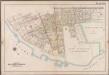
Plate 10: [Bounded by 85th Street, 1st Avenue, 86th Street, 2nd Avenue, 87th Street, 3rd Avenue., 88th Street, 5th Avenue, 86th Street, New Utrecht Avenue, Atlantic Avenue, (Dyker Beach Park) 7th Avenue, Warehouse Avenue, Cropsey Avenue, Dahlgreen Place, 92nd Street, ((Fort Hamilton) Fort Hamilton Avenue, Denyse Street, 5th Avenue and Bay Ridge Parkway.]; Atlas of the borough of Brooklyn, city of New York: from actual surveys and official plans by George W. and Walter S. Bromley.
from Atlas of the borough of Brooklyn, city of New York : from actual surveys and official plans by George W. and Walter S. Bromley. G.W. Bromley & Co.,
Part of Ward 30, Land Map Sections, Nos. 17, 18 & 19. Volume 2, Brooklyn Borough, New York City.
from Atlas of the Brooklyn borough of the City of New York : originally Kings Co.; complete in three volumes ... based upon official maps and plans ... / by and under the supervision of Hugo Ullitz, C.E.
Plate 10: [Bounded by 72nd Street, Fourteenth Avenue, 86th Street and Stewart Avenue.]
from Robinson's atlas of Kings County, New York : compiled from official records ... / under the direction of E. Robinson.
Part of Ward 30, Land Map Section, No. 18. Volume 2, Brooklyn Borough, New York City.
from Atlas of the Brooklyn borough of the City of New York : originally Kings Co.; complete in three volumes ... based upon official maps and plans ... / by and under the supervision of Hugo Ullitz, C.E.
Brooklyn, Vol. 6, Double Page Plate No. 15; Part of Ward 30, Section 18; [Map bounded by 72nd St., 7th Ave.; Including 10th Ave., 81st St., 5th Ave.]
from Ward 30.
Brooklyn, Vol. 6, Double Page Plate No. 14; Part of Ward 30, Section 18; [Map bounded by 5th Ave., 18th St.; Including Ridge Blvd., Bay Ridge Ave.]
from Ward 30.
Brooklyn, Vol. 6, Double Page Plate No. 16; Part of Ward 30, Sections 17, 18 & 19; [Map bounded by 67th St., 12th Ave., 76th St.; Including 7th Ave., 8th Ave.]
from Ward 30.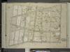
Brooklyn, Vol. 6, Double Page Plate No. 25; Part of Ward 30, Section 18; [Map bounded by 10th Ave., 92nd St.; Including 5th Ave., 81st St.]
from Ward 30.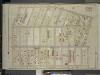
Brooklyn, Vol. 6, Double Page Plate No. 26; Part of Ward 30, Section 18; [Map bounded by 5th Ave., 91st St.; Including Ridge Blvd., 80th St.]
from Ward 30.
Brooklyn, Vol. 6, Double Page Plate No. 24; Part of Ward 30, Sections 18 & 19; [Map bounded by 13th Ave., 86th St.; Including 10th Ave., 76th St.]
from Ward 30.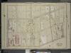
Brooklyn, Vol. 6, Double Page Plate No. 10; Part of Ward 30, Section 18; [Map bounded by 8th Ave., 72nd St.; Including 5th Ave., 60th St.]
from Ward 30.
Brooklyn V. 11, Plate No. 86 [Map bounded by 64th St., 9th Ave., Bay Ridge Ave., 8th Ave.]
From Atlas 95. Vol. 11, 1905.
Brooklyn Vol. A Plate No. 12 [Map bounded by 92nd St., 93rd St., 94th St., 95th St.; Including 2nd Ave., 3rd Ave., 4th Ave.]
From Atlas 61. Vol. A, 1893.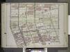
Brooklyn, Vol. 2, Double Page Plate No. 18; Part of Ward 30, Section 18; [Map bounded by 60th St., 8th Ave., 74th St.; Including Ridge Blvd., 2nd Ave.] / by and under the direction of Hugo Ullitz.
From Volume 2.
Part of the Town of New Utrecht, Kings Co., N.Y.
from Robinson's atlas of Kings County, New York : compiled from official records ... / under the direction of E. Robinson.
Plate 8: [Bounded by Mackay Place, Narrows Avenue, 71st Street, First Avenue, 72nd Street, Second Avenue, 73rd Street, Third Avenue, 74th Street, Fourth Avenue, 75th Street, Stewart Avenue, 89th Street, Third Avenue, 87th Street, First Avenue, 86th Stree
from Robinson's atlas of Kings County, New York : compiled from official records ... / under the direction of E. Robinson.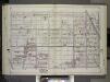
Brooklyn, Vol. 2, Double Page Plate No. 17; Part of Ward 30, Sections 17, 18 & 19; [Map bounded by 61st St., 15th Ave., 74th St.; Including 7th Ave., 8th Ave.] / by and under the direction of Hugo Ullitz.
From Volume 2.
Part of Ward 30, Land Map Section, No. 18. Volume 2, Brooklyn Borough, New York City.
from Atlas of the Brooklyn borough of the City of New York : originally Kings Co.; complete in three volumes ... based upon official maps and plans ... / by and under the supervision of Hugo Ullitz, C.E.
Plate 11: [Bounded by 58th Street, Fourteenth Avenue, 72nd Street, Stewart Avenue Cowenhoven Lane and Seventh Avenue.]
from Robinson's atlas of Kings County, New York : compiled from official records ... / under the direction of E. Robinson.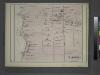
Bayridge. Town of New Utrecht, Kings Co.
from Atlas of Long Island, New York. From recent and actual surveys and records.
Plate 7: [Bounded by 60th Street, Seventh Avenue, 66th Street, Stewart Avenue, 75th Street, Fourth Avenue, 72nd Street, Second Avenue, 71st Street, First Avenue, Mackay Place, Shore Road and New York Bay Pier Line.]
from Robinson's atlas of Kings County, New York : compiled from official records ... / under the direction of E. Robinson.
Fort Hamilton. Town of New Utrecht, Kings Co. L.I.
from Atlas of Long Island, New York. From recent and actual surveys and records.
Double Page Plate No. 19: [Bounded by 92nd Street, Third Avenue, 91st Street, Fifth Avenue, 86th Street, Fort Hamilton Avenue (Smith Avenue) and (Proposed Bay Ridge Parkway) Narrows Avenue.]
from Atlas of the Brooklyn borough of the City of New York : originally Kings Co.; complete in three volumes ... based upon official maps and plans ... / by and under the supervision of Hugo Ullitz, C.E.
Map of a farm at Fort Hamilton in the town of New Utrecht.
from Brooklyn
Double Page Plate No. 23: [Bounded by (U.S. Government Reservation) Fort Hamilton Avenue, 86th Street, Bay 2nd Street, Benson Avenue, Delaplaine Street, Atlantic Avenue, (Dyker Beach Park) Seventh Avenue, 170th Street, Battery Avenue, Cropsey Avenue, Dah
from Atlas of the Brooklyn borough of the City of New York : originally Kings Co.; complete in three volumes ... based upon official maps and plans ... / by and under the supervision of Hugo Ullitz, C.E.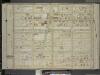
Brooklyn, Vol. 6, Double Page Plate No. 9; Part of Ward 30, Section 17; [Map bounded by 58th St., 12th Ave.; Including 67th St., 8th Ave.]
from Ward 30.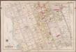
Plate 2: [Bounded by Mackay Pl., 1st Ave., 72nd St., 2nd Ave., 73rd St., 3rd Ave., 74th St., 4th Ave., 75th St., 6th Ave., 78th St., 5th Ave., 89th St., 3rd Ave., 88th St., 2nd Ave., 87th St., 1st Ave., 86th St. & Bayridge Pkwy.]; Atlas of the borough of Brooklyn, city of New York: from actual surveys and official plans by George W. and Walter S. Bromley.
from Atlas of the borough of Brooklyn, city of New York : from actual surveys and official plans by George W. and Walter S. Bromley. G.W. Bromley & Co.,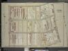
Brooklyn, Vol. 6, Double Page Plate No. 11; Part of Ward 30, Section 18; [Map bounded by 5th Ave., Bayridge Ave., Ridge Blvd.; Including 2nd Ave., 60th St.]
from Ward 30.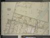
Brooklyn, Vol. 6, Double Page Plate No. 30; Part of Ward 30, Section 18; [Map bounded by Battery Ave., Fort Hamilton Ave., Bay Ridge Parkway; Including 3rd Ave., 91st St., 5th Ave., 92nd St.]; Sub Plan; [Map bounded by Fort Hamilton Ave., Bay
from Ward 30.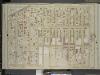
![Plate 10: [Bounded by 85th Street, 1st Avenue, 86th Street, 2nd Avenue, 87th Street, 3rd Avenue., 88th Street, 5th Avenue, 86th Street, New Utrecht Avenue, Atlantic Avenue, (Dyker Beach Park) 7th Avenue, Warehouse Avenue, Cropsey Avenue, Dahlgreen Place, 92nd Street, ((Fort Hamilton) Fort Hamilton Avenue, Denyse Street, 5th Avenue and Bay Ridge Parkway.]; Atlas of the borough of Brooklyn, city of New York: from actual surveys and official plans by George W. and Walter S. Bromley.](https://images-2.georeferencer.com/images/iiif/212636844754/full/,300/0/native.jpg)

