Maps of Long Beach
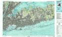
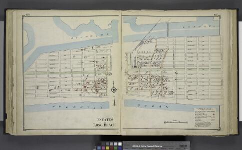
Estates of Long Beach
from Atlas of Nassau County, Long Island, N.Y. Complete in one volume. Historical, statistical. Based upon maps on file at the county seat in Mineola and upon private plans and surveys furnished by surveyors and individual owners. Supplemented by careful measurements & field observations by our own corps of engineers.
Lawrence
1 : 24000
Lawrence
1 : 24000
Lawrence
1 : 24000
Lawrence
1 : 24000
Lawrence
1 : 24000
Hempstead
1 : 62500
Hempstead
1 : 62500
Hempstead
1 : 62500
Hempstead
1 : 62500
Hempstead
1 : 62500
Hempstead
1 : 62500
Hempstead
1 : 62500
Hempstead
1 : 62500
Hempstead
1 : 62500
Hempstead
1 : 62500
Hempstead
1 : 62500
Hempstead
1 : 62500
Street Indexed map of the Borough of Queens, also showing the Congressional Districts.
From Queens
Outline and Index Map of the Borough of Queens, City of New York.
from Atlas of the city of New York, borough of Queens, Long Island City, Newtown, Flushing, Jamaica, Far Rockaway, from actual surveys and official plans / by George W. and Walter S. Bromley.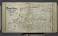
Lower section Index Map of Nassau County Long Island Published by E. Belcher Hype. 97 Liberty St. Brooklyn, 5 Beekman St. Manhattan. 1914.
from Atlas of Nassau County, Long Island, N.Y. Complete in one volume. Historical, statistical. Based upon maps on file at the county seat in Mineola and upon private plans and surveys furnished by surveyors and individual owners. Supplemented by careful measurements & field observations by our own corps of engineers.
New map of Kings and Queens counties : from actual Surveys.
From Brooklyn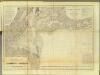
New York Bay, Harbor.
1 : 80000 Hassler, F. R.
New York City Free Public Educational Institutions, 1911 ; prepared by the Dept. of Public Education, American Museum of Natural History.
From Manhattan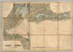
New York Bay And Harbor.
1 : 79200 United States Coast Survey
Map of the Borough of Brooklyn, N. Y., and vicinity showing the street railway system controlled by the Brooklyn rapid transit system.
From Brooklyn
Greater New York's census districts, 1920 : compiled from map prepared 1915-1918 for the 1920 census by the New York Federation of Churches.
From Manhattan
New York City and vicinity / H.M. Wilson, geographer in charge ; triangulation by U.S. Coast and Geodetic Survey ; topography by S.H. Bodfish ... [et al.]
1 : 62500 Annotatie geografische gegevens: Opname: 1887-1889, 1897 Wilson, H. M.; Bodfish, S. H.; US Coast and Geodetic Survey [Washington, D.C. : U.S. Geological Survey]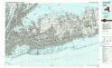
Long Island West
1 : 100000