Maps of Long Beach

Lawrence
1 : 24000
Lawrence
1 : 24000
Lawrence
1 : 24000
Lawrence
1 : 24000
Lawrence
1 : 24000
Estates of Long Beach
from Atlas of Nassau County, Long Island, N.Y. Complete in one volume. Historical, statistical. Based upon maps on file at the county seat in Mineola and upon private plans and surveys furnished by surveyors and individual owners. Supplemented by careful measurements & field observations by our own corps of engineers.
Use District Map Section No. 31; Use district map / City of New York, Board of Estimate and Apportionment.
from Use district map / City of New York, Board of Estimate and Apportionment. New York (N.Y.). Board of Estimate and Apportionment,
Height District Map Section No. 31; Height district map / City of New York, Board of Estimate and Apportionment.
from Height district map / City of New York, Board of Estimate and Apportionment. New York (N.Y.). Board of Estimate and Apportionment,
Area District Map Section No. 31; Area district map / City of New York, Board of Estimate and Apportionment.
from Area district map / City of New York, Board of Estimate and Apportionment. New York (N.Y.). Board of Estimate and Apportionment,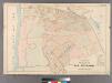
Part of the Village of Far Rockaway.
from Atlas of Queens Co., Long Island, New York / compiled from official records, private plans & actual surveys by and under the direction of Chester Wolverton.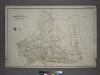
[Plate 44: Bounded by (Banister Creek) Somerset Avenue, (Atlantic Ocean) Jarvis Lane, South Street, Central Avenue, Carleton Avenue, Remsen Avenue, Mc Neil Avenue and Fenwick Avenue.]
from Atlas of the city of New York, borough of Queens, Long Island City, Newtown, Flushing, Jamaica, Far Rockaway, from actual surveys and official plans / by George W. and Walter S. Bromley.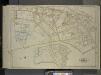
Queens, Vol. 1, Double Page Plate No. 32; Part of Ward 5; Farrockaway; [Map bounded by Central Ave., Crescent Ave., Mc. Neil Ave.; Including Broadway Jarvis Lane, South St.]; Sub Plan; [Map bounded by Jarvis Lane, Oak St.; Including Former Vil
from Fourth and fifth wards: Jamaica and Rockaway.
Hempstead
1 : 62500
Hempstead
1 : 62500
Hempstead
1 : 62500
Hempstead
1 : 62500
Hempstead
1 : 62500
Hempstead
1 : 62500
Hempstead
1 : 62500
Hempstead
1 : 62500
Hempstead
1 : 62500
Hempstead
1 : 62500
Hempstead
1 : 62500
Hempstead
1 : 62500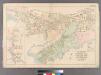
Plate 14: Villages of Woodsburgh, Cedarhurst and Lawrence, Town of Hempstead.
from Atlas of Queens Co., Long Island, New York / compiled from official records, private plans & actual surveys by and under the direction of Chester Wolverton.
Inwood, Cedarhurst Vicinity
from Atlas of Nassau County, Long Island, N.Y. Complete in one volume. Historical, statistical. Based upon maps on file at the county seat in Mineola and upon private plans and surveys furnished by surveyors and individual owners. Supplemented by careful measurements & field observations by our own corps of engineers.
Key
From Atlas 145a. Vol. 8, 1912.
Height District Map Section No. 25; Height district map / City of New York, Board of Estimate and Apportionment.
from Height district map / City of New York, Board of Estimate and Apportionment. New York (N.Y.). Board of Estimate and Apportionment,
Area District Map Section No. 25; Area district map / City of New York, Board of Estimate and Apportionment.
from Area district map / City of New York, Board of Estimate and Apportionment. New York (N.Y.). Board of Estimate and Apportionment,