Maps of Saratoga County

Saratoga [Township]
from New topographical atlas of Saratoga Co., New York, from actual surveys by S. N. & D. G. Beers and assistants.
Quaker Springs
1 : 24000
Quaker Springs
1 : 24000
Quaker Springs
1 : 24000
Schuylerville
1 : 24000
Schuylerville
1 : 24000
Schuylerville Business Directory. ; Schuylerville [Village]
from New topographical atlas of Saratoga Co., New York, from actual surveys by S. N. & D. G. Beers and assistants.
Plan of the Encampment and position of the Army under General Burgoyne at Sword's House on Hudson's River
Plan of the Encampment and position of the Army under ... General Burgoyne at Sword's House on Hudson's River near Stillwater on Sept. 17th, with the Positions of that part of the Army engaged on the 19th Sept., 1777. Drawn by W.C. Wilkinson ... Engraved [and] published by W. Faden. London
Grangerville [Village]; Grangerville Business Directory. ; Victory [Village]; Charlton [Village]; Charlton Business Directory. ; Victory Business Directory. ; Rexford Flats Business Directory. ; Rexford Flats [Village]
from New topographical atlas of Saratoga Co., New York, from actual surveys by S. N. & D. G. Beers and assistants.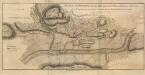
Plan of the position which the Army under Lt Genl Burgoine took at saratoga on the 10th of Septr, 1777,
Plan of the position which the Army under Lt. Genl. Burgoine took at saratoga on the 10th of Septr., 1777, and in which it remained till the Convention was signed. London
Schuylerville
1 : 62500
Schuylerville
1 : 62500
Schuylerville
1 : 62500
Schuylerville
1 : 62500
Schuylerville
1 : 62500
Schuylerville
1 : 62500
Schuylerville
1 : 62500
Schuylerville
1 : 62500
Schuylerville
1 : 62500
Schuylerville
1 : 62500
Schuylerville
1 : 62500
Schuylerville
1 : 62500
Saratoga Springs [Township]
from New topographical atlas of Saratoga Co., New York, from actual surveys by S. N. & D. G. Beers and assistants.
Northumberland [Township]
from New topographical atlas of Saratoga Co., New York, from actual surveys by S. N. & D. G. Beers and assistants.
Stillwater [Township]
from New topographical atlas of Saratoga Co., New York, from actual surveys by S. N. & D. G. Beers and assistants.
Wilton [Township]
from New topographical atlas of Saratoga Co., New York, from actual surveys by S. N. & D. G. Beers and assistants.
Stillwater, Saratoga County, New York.
1 : 42240 Beers, B.G.
Saratoga Springs, Saratoga County, New York.
1 : 42240 Beers, B.G.
Wilton, Saratoga County, New York.
1 : 42240 Beers, B.G.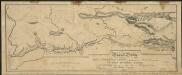
![Saratoga [Township]](https://images-2.georeferencer.com/images/iiif/455657595203/full/,300/0/native.jpg)

