Maps of Queens County

Map of the city of New-York extending northward to Fiftieth St. / surveyed and drawn by John F. Harrison, C.E.
from Manhattan
Sheet 12: [Bounded by Sixth Avenue, E. Fifty Ninth Street, Avenue A, E. Fifty-Fourth Street, First Avenue and E. Fortieth Street.]
from Plan of New York City, from the Battery to Spuyten Duyvil Creek. Showing every lot and building thereon; old farm lines, strreet numbers at the corners of blocks, railroads, steamboat landings, bulkhead and pier lines, etc. Based on the surveys made by Messrs. Randall & Blackwell, and on the special survey by J. F. Harrison.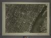
8D - N.Y. City (Aerial Set).
from Sectional aerial maps of the City of New York / [photographed and assembled under the direction of the chief engineer, July 1st, 1924].
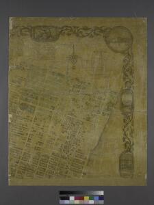
Sackersdorff Farm Set.
from Maps of farms commonly called the Blue book, 1815 : drawn from the original on file in the street commissioner's office in the City of New York, together with lines of streets and avenues / laid out by John Randel, jr., 1819-20.
18. Ward 19, 21.
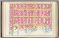
1 : 2400 G.W. Bromley & Co.; Geo. W. Bromley & E. Robinson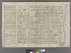
Part of Ward 19, New York City.
from Atlas of the city of New York : embracing all territory within its corporate limits from official records, private plans & actual surveys / by and under the supervision of E. Robinson & R.H. Pidgeon, civil engineers.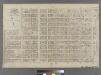
[Plate 18: Bounded by E. 64th Street, Avenue A, E. 52nd Street, W. 52nd Street, Sixth Avenue, W. 59th Street and Fifth Avenue.]
from Atlas of the city of New York : embracing all territory within its corporate limits from official records, private plans & actual surveys / by and under the supervision of E. Robinson & R.H. Pidgeon, civil engineers.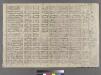
[Plate 13: Bounded by W. 40th Street, E. 40th Street, First Avenue (Harlem River, Lumber Yards), E. 27th Street, W. 27th Street and Sixth Avenue.]
from Atlas of the city of New York : embracing all territory within its corporate limits from official records, private plans & actual surveys / by and under the supervision of E. Robinson & R.H. Pidgeon, civil engineers.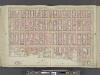
Manhattan, Double Page Plate No. 21 [Map bounded by Lexington Ave., E. 57th St., East River, E. 40th St.]
From Atlas of the city of New York, Manhattan Island. From actual surveys and official plans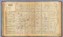
19. Ward 19.
1 : 2400 G.W. Bromley & Co.; Geo. W. Bromley & E. Robinson
Sheet 10: [Bounded by E. Fortieth Street, First Avenue, E. Twentieth Street and Sixth Avenue.]
from Plan of New York City, from the Battery to Spuyten Duyvil Creek. Showing every lot and building thereon; old farm lines, strreet numbers at the corners of blocks, railroads, steamboat landings, bulkhead and pier lines, etc. Based on the surveys made by Messrs. Randall & Blackwell, and on the special survey by J. F. Harrison.
[Plate 21: Bounded by Lexington Avenue, E. 57th Street, Avenue A, E. 54th Street, First Avenue (East River), and E. 40th Street.]
from Atlas of the city of New York, Manhattan Island. From actual surveys and official plans / by George W. and Walter S. Bromley.
Part of Section 5 : New York City.
from Atlas of the city of New York, borough of Manhattan. From actual surveys and official plans / by George W. and Walter S. Bromley.
Part of Section 5 : New York City.
from Atlas of the city of New York, Manhattan Island. From actual surveys and official plans / by George W. and Walter S. Bromley.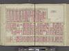
Manhattan, Double Page Plate No. 22 [Map bounded by 6th Ave., E. 64th St., Lexington Ave., E. 47th St.]
From Atlas of the city of New York, Manhattan Island. From actual surveys and official plans
[Plate 16: Bounded by Lexington Avenue, E. 40th Street, First Avenue [East River], and E. 25th Street.]
from Atlas of the city of New York, borough of Manhattan. From actual surveys and official plans / by George W. and Walter S. Bromley.
Part of Section 3 : New York City.
from Atlas of the city of New York, Manhattan Island. From actual surveys and official plans / by George W. and Walter S. Bromley.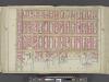
Manhattan, Double Page Plate No. 16 [Map bounded by Lexington Ave., E. 40th St., East River, E. 25th St.]
From Atlas of the city of New York, Manhattan Island. From actual surveys and official plans
[Plate 22: Bounded by Sixth Avenue, Central Park South, Fifth Avenue, E. 64th Street, Lexington Avenue, and E. 47th Street.]
from Atlas of the city of New York, borough of Manhattan. From actual surveys and official plans / by George W. and Walter S. Bromley.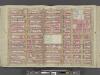
Manhattan, Double Page Plate No. 20 [Map bounded by W. 47th St., Lexington Ave., W. 36th St., 8th Ave.]
From Atlas of the city of New York, Manhattan Island. From actual surveys and official plans
Sackersdorff Farm Set.
from Maps of farms commonly called the Blue book, 1815 : drawn from the original on file in the street commissioner's office in the City of New York, together with lines of streets and avenues / laid out by John Randel, jr., 1819-20.
13. Ward 21.
1 : 2400 G.W. Bromley & Co.; Geo. W. Bromley & E. Robinson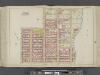
Manhattan, Double Page Plate No. 27 [Map bounded by E. 68th St., East River, E. 57th St., Lexington Ave.]
From Atlas of the city of New York, Manhattan Island. From actual surveys and official plans
Sackersdorff Farm Set.
from Maps of farms commonly called the Blue book, 1815 : drawn from the original on file in the street commissioner's office in the City of New York, together with lines of streets and avenues / laid out by John Randel, jr., 1819-20.
Sackersdorff Farm Set.
from Maps of farms commonly called the Blue book, 1815 : drawn from the original on file in the street commissioner's office in the City of New York, together with lines of streets and avenues / laid out by John Randel, jr., 1819-20.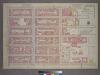
Plate 12, Part of Section 3: [Bounded by E. 32nd Street, First Avenue, E. 26th Street and Second Avenue.]
from Atlas of the city of New York, borough of Manhattan. From actual surveys and official plans / by George W. and Walter S. Bromley.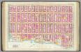
Pl. 21: ward 19.
1 : 1800 Bromley, George Washington; Bromley, Walter Scott
Part of Sections 3, 4 & 5 : New York City.
from Atlas of the city of New York, Manhattan Island. From actual surveys and official plans / by George W. and Walter S. Bromley.
[Plate 20: Bounded by W. 47th Street, E. 47th Street, Lexington Avenue, E. 36th Street, W. 36th Street, and Eighth Avenue.]
from Atlas of the city of New York, borough of Manhattan. From actual surveys and official plans / by George W. and Walter S. Bromley.