Maps of Hudson County

Part of Section 3 : Plate 58.
from Atlas of the borough of Manhattan, city of New York.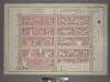
Plate 19, Part of Section 3: [Bounded by (W. 37th Street, Ninth Avenue, W. 32nd Street and Eleventh Avenue.]
from Atlas of the city of New York, borough of Manhattan. From actual surveys and official plans / by George W. and Walter S. Bromley.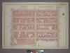
Plate 19, Part of Section 3: [Bounded by W. 37th Street, Ninth Avenue, W. 32nd Street and Eleventh Avenue.]
from Atlas of the city of New York, borough of Manhattan. From actual surveys and official plans / by George W. and Walter S. Bromley.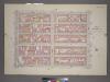
Plate 19, Part of Section 3: [Bounded by (W. 37th Street, Ninth Avenue, W. 32nd Street and Eleventh Avenue.]
from Atlas of the city of New York, borough of Manhattan. From actual surveys and official plans / by George W. and Walter S. Bromley.
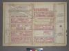
Part of Sections 3 & 4 : Plate 63.
from Atlas of the borough of Manhattan, city of New York.
[Plate 94: Map bounded by West 37th Street, Eighth Avenue, West 32nd Street, Tenth Avenue.]
from Maps of the city of New York / surveyed under directions of insurance companies of said city.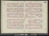
Manhattan, V. 5, Double Page Plate No. 92 [Map bounded by W. 37th St., 8th Ave., W. 32nd St., 10th Ave.]
From Atlas 42.55. Vol. 5, 1890.
Plate 93: Map bounded by West 37th Street, Tenth Avenue, West 32nd Street, Hudson River
from Maps of the city of New York.
Plate 92: Map bounded by West 37th Street, Eighth Avenue, West 32nd Street, Tenth Avenue
from Maps of the city of New York.
Manhattan, V. 5, Double Page Plate No. 93 [Map bounded by W. 37th St., 10th Ave., W. 32nd St., Hudson River]
From Atlas 42.55. Vol. 5, 1890.
[Plate 95: Map bounded by West 37th Street, Tenth Avenue, West 32nd Street, Eleventh Avenue.]
from Maps of the city of New York / surveyed under directions of insurance companies of said city.
Plate 90: Map bounded by West 32nd Street, Tenth Avenue, West 27th Street, Hudson River
from Maps of the city of New York.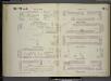
[Plate 91: Map bounded by West 32nd Street, Eighth Avenue, West 27th Street, Tenth Avenue.]
from Maps of the city of New York / surveyed under directions of insurance companies of said city.
[Plate 92: Map bounded by West 32nd Street, Tenth Avenue, West 27th Street, Eleventh Avenue.]
from Maps of the city of New York / surveyed under directions of insurance companies of said city.
[Plate 18: Bounded by W. 36th Street, Eighth Avenue, W. 25th Street, Thirteenth Avenue, [Hudson River, Piers 55-60], and [Hudson River, Piers 61-66], Twelfth Avenue.]
from Atlas of the city of New York, borough of Manhattan. From actual surveys and official plans / by George W. and Walter S. Bromley.
Part of Section 3 : New York City.
from Atlas of the city of New York, Manhattan Island. From actual surveys and official plans / by George W. and Walter S. Bromley.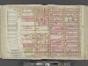
Manhattan, Double Page Plate No. 18 [Map bounded by W. 36th St., 8th Ave., W. 25th St., Hudson River]
From Atlas of the city of New York, Manhattan Island. From actual surveys and official plans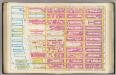
Pl. 18: wards 16, 20.
1 : 1800 Bromley, George Washington; Bromley, Walter Scott
Manhattan, Double Page Plate No. 19 [Map bounded by W. 47th St., 8th Ave., W. 36th St., Hudson River]
From Atlas of the city of New York, Manhattan Island. From actual surveys and official plans
Plate 19: Bounded by W. 47th Street, Eighth Avenue, W. 36th Street and (Hudson River, Piers 66-77) Twelfth Avenue.
from Atlas of the city of New York, Manhattan Island. From actual surveys and official plans / by George W. and Walter S. Bromley.
Part of Sections 3 & 4 : New York City.
from Atlas of the city of New York, borough of Manhattan. From actual surveys and official plans / by George W. and Walter S. Bromley.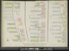
Manhattan, V. 5, Double Page Plate [Map bounded by Hudson River, 13th Ave., 12th Ave.]
From Atlas 42.55. Vol. 5, 1890.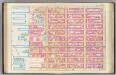
Pl. 19: wards 20, 22.
1 : 1800 Bromley, George Washington; Bromley, Walter Scott
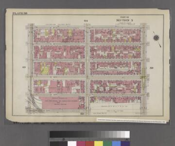
Part of Sections 3 & 4 : Plate 64.
from Atlas of the borough of Manhattan, city of New York.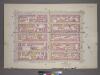
Plate 28, Part of Sections 3&4: [Bounded by W. 42nd Street, Ninth Avenue, W. 37th Street and Eleventh Avenue.]
from Atlas of the city of New York, borough of Manhattan. From actual surveys and official plans / by George W. and Walter S. Bromley.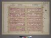
Plate 28, Part of Sections 3&4: [Bounded by W. 42nd Street, Ninth Avenue, W. 37th Street and Eleventh Avenue.]
from Atlas of the city of New York, borough of Manhattan. From actual surveys and official plans / by George W. and Walter S. Bromley.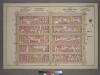
Plate 28, Part of Sections 3&4: [Bounded by W. 42nd Street, Ninth Avenue, W. 37th Street and Eleventh Avenue.]
from Atlas of the city of New York, borough of Manhattan. From actual surveys and official plans / by George W. and Walter S. Bromley.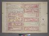
Plate 16, Part of Section 3: [Bounded by W. 32nd Street, Ninth Avenue, W. 26th Street and Eleventh Avenue.]
from Atlas of the city of New York, borough of Manhattan. From actual surveys and official plans / by George W. and Walter S. Bromley.
Part of Section 3 : Plate 53.
from Atlas of the borough of Manhattan, city of New York.