Maps of Hudson County
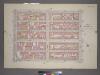
Plate 19, Part of Section 3: [Bounded by (W. 37th Street, Ninth Avenue, W. 32nd Street and Eleventh Avenue.]
from Atlas of the city of New York, borough of Manhattan. From actual surveys and official plans / by George W. and Walter S. Bromley.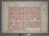
Plate 19, Part of Section 3: [Bounded by (W. 37th Street, Ninth Avenue, W. 32nd Street and Eleventh Avenue.]
from Atlas of the city of New York, borough of Manhattan. From actual surveys and official plans / by George W. and Walter S. Bromley.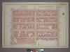
Plate 19, Part of Section 3: [Bounded by W. 37th Street, Ninth Avenue, W. 32nd Street and Eleventh Avenue.]
from Atlas of the city of New York, borough of Manhattan. From actual surveys and official plans / by George W. and Walter S. Bromley.
Part of Section 3 : Plate 58.
from Atlas of the borough of Manhattan, city of New York.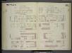
[Plate 94: Map bounded by West 37th Street, Eighth Avenue, West 32nd Street, Tenth Avenue.]
from Maps of the city of New York / surveyed under directions of insurance companies of said city.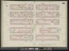
Manhattan, V. 5, Double Page Plate No. 92 [Map bounded by W. 37th St., 8th Ave., W. 32nd St., 10th Ave.]
From Atlas 42.55. Vol. 5, 1890.
Part of Sections 3 & 4 : Plate 63.
from Atlas of the borough of Manhattan, city of New York.
Plate 92: Map bounded by West 37th Street, Eighth Avenue, West 32nd Street, Tenth Avenue
from Maps of the city of New York.
[Plate 95: Map bounded by West 37th Street, Tenth Avenue, West 32nd Street, Eleventh Avenue.]
from Maps of the city of New York / surveyed under directions of insurance companies of said city.
Plate 93: Map bounded by West 37th Street, Tenth Avenue, West 32nd Street, Hudson River
from Maps of the city of New York.
Manhattan, V. 5, Double Page Plate No. 93 [Map bounded by W. 37th St., 10th Ave., W. 32nd St., Hudson River]
From Atlas 42.55. Vol. 5, 1890.
[Plate 18: Bounded by W. 36th Street, Eighth Avenue, W. 25th Street, Thirteenth Avenue, [Hudson River, Piers 55-60], and [Hudson River, Piers 61-66], Twelfth Avenue.]
from Atlas of the city of New York, borough of Manhattan. From actual surveys and official plans / by George W. and Walter S. Bromley.
Part of Section 3 : New York City.
from Atlas of the city of New York, Manhattan Island. From actual surveys and official plans / by George W. and Walter S. Bromley.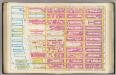
Pl. 18: wards 16, 20.
1 : 1800 Bromley, George Washington; Bromley, Walter Scott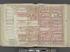
Manhattan, Double Page Plate No. 18 [Map bounded by W. 36th St., 8th Ave., W. 25th St., Hudson River]
From Atlas of the city of New York, Manhattan Island. From actual surveys and official plans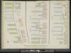
Manhattan, V. 5, Double Page Plate [Map bounded by Hudson River, 13th Ave., 12th Ave.]
From Atlas 42.55. Vol. 5, 1890.
Part of Sections 3 & 4 : Plate 64.
from Atlas of the borough of Manhattan, city of New York.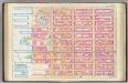
Pl. 19: wards 20, 22.
1 : 1800 Bromley, George Washington; Bromley, Walter Scott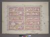
Plate 28, Part of Sections 3&4: [Bounded by W. 42nd Street, Ninth Avenue, W. 37th Street and Eleventh Avenue.]
from Atlas of the city of New York, borough of Manhattan. From actual surveys and official plans / by George W. and Walter S. Bromley.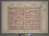
Plate 28, Part of Sections 3&4: [Bounded by W. 42nd Street, Ninth Avenue, W. 37th Street and Eleventh Avenue.]
from Atlas of the city of New York, borough of Manhattan. From actual surveys and official plans / by George W. and Walter S. Bromley.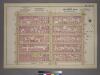
Plate 28, Part of Sections 3&4: [Bounded by W. 42nd Street, Ninth Avenue, W. 37th Street and Eleventh Avenue.]
from Atlas of the city of New York, borough of Manhattan. From actual surveys and official plans / by George W. and Walter S. Bromley.
Part of Section 3 : Plate 53.
from Atlas of the borough of Manhattan, city of New York.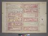
Plate 16, Part of Section 3: [Bounded by W. 32nd Street, Ninth Avenue, W. 26th Street and Eleventh Avenue.]
from Atlas of the city of New York, borough of Manhattan. From actual surveys and official plans / by George W. and Walter S. Bromley.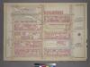
Plate 16, Part of Section 3: [Bounded by W. 32nd Street, Ninth Avenue, W. 26th Street and Eleventh Avenue.]
from Atlas of the city of New York, borough of Manhattan. From actual surveys and official plans / by George W. and Walter S. Bromley.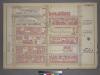
Plate 16, Part of Section 3: [Bounded by W. 32nd Street, Ninth Avenue, W. 26th Street and Eleventh Avenue.]
from Atlas of the city of New York, borough of Manhattan. From actual surveys and official plans / by George W. and Walter S. Bromley.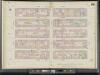
Manhattan, V. 5, Double Page Plate No. 95 [Map bounded by W. 42nd St., 8th Ave., W. 37th St., 10th Ave.]
From Atlas 42.55. Vol. 5, 1890.
[Plate 91: Map bounded by West 32nd Street, Eighth Avenue, West 27th Street, Tenth Avenue.]
from Maps of the city of New York / surveyed under directions of insurance companies of said city.
[Map bounded by Pier - Line, W. 36th St, Eleventh Avenue, W. 28th St; Including Twelfth Avenue, W. 29th St, W. 30th St, W. 31st St, W. 32nd St, W. 33th St, W. 34th St, W. 35th St]
from Maps of the wharves & piers from the Battery to 61st street on the Hudson river and from the Battery to 41st street on the East river, New York. Surveyed by I.C. Buckhout, city surveyor.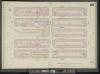
Manhattan, V. 5, Double Page Plate No. 89 [Map bounded by W. 32nd St., 8th Ave., W. 27th St., 10th Ave.]
From Atlas 42.55. Vol. 5, 1890.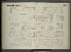
![Plate 19, Part of Section 3: [Bounded by (W. 37th Street, Ninth Avenue, W. 32nd Street and Eleventh Avenue.]](https://images-2.georeferencer.com/images/iiif/681712426912/full/,300/0/native.jpg)

