Maps of Venezuela

Venezuela cum parte Australi Novae Andalusiae
from America: being the latest, and most accurate description of the Nevv vvorld; containing the original of the inhabitants, and the remarkable voyages thither. The conquest of the vast empires of Mexico and Peru, and other large provinces and territories, with the several European plantations in those parts. Also their cities, fortresses, towns, temples, mountains, and rivers. Their habits, customs, manners, and religions. Their plants, beasts, birds, and serpents. With an appendix, containing, besides several other considerable additions, a brief survey of what hath been discover'd of the vnknown south-land and the Arctick region. Collected from most authentick authors, augmented with later observations, and adorn'd with maps and sculptures, by John Ogilby ...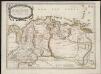
Terre ferme ou sont les governations ou gouvernemens de Terre ferme, Cartagene Ste. Marthe, Rio de la Hache, Venezuela, nouvelle Andalusie Popayein, nouveau royme de Grenade, &c.
1 : 4562000
Partie Occidentale de la Terre Ferme
En 1748 se empezaron a publicar los primeros resultados de la Expedición Geodésica francesa al Ecuador (1735-1744), del entonces Virreinato del Perú. Charles-Marie de La Condamine (1701-1774), uno de los protagonistas de dicha expedición, renovó el interés del público europeo hacia las singularidades geográficas y naturales del subcontinente suramericano. La Condamine, quien recorrió el Río Amazonas antes de su regreso a Europa, animó la controversia sobre la existencia de una conexión fluvial entre los ríos Amazonas y Orinoco. Este mapa muestra conexiones entre los ríos Orinoco, Caquetá y Río Negro (estos dos últimos afluentes del Amazonas), anotando que los portugueses remontaron en 1743 el río Amazonas y llegaron al Orinoco por el Río Negro (“Les Portugais ont remonté en 1743 de la riv. des Amazones dans l’Orinoque par le Río Negro”). El mapa de los Vaugondy mezcla estas novedades aportadas por La Condamine, con información fabulosa procedente de la cartografía del siglo XVII, como el lago Cassipa, asociado al legendario Lago Parime y al mito del Dorado, buscados sin éxito hasta el siglo XIX. La cuestión de la existencia de una posible conexión fluvial entre los ríos Amazonas y Orinoco tenía implicaciones geopolíticas que superaban el asunto de la potencial navegación entre la cuenca del Orinoco y la del Amazonas, ya que impugnaba los supuestos hidrográficos que sustentaban parte de la delimitación de las fronteras amazónicas entre el imperio español y el portugués en América del Sur. Esto se haría patente en la renegociación de los límites suramericanos de ambas potencias a través del Tratado de Madrid, en 1750. Robert de Vaugondy, Gilles . (1688-1766); Robert de Vaugondy, Didier (1723-1786)
Mapa politico de Venezuela, antes 1810, 1840.
1 : 5300000 Codazzi, Agustin, 1793-1859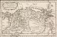
Terre Ferme, Nouveau Royme. de Grenade, &c
1 : 10000000 Sanson, Nicolas, 1600-1667 Chez P. Mariette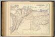
New Granada & Venezuela.
1 : 3801600 Fullarton, A. & Co.
Mapas fisicos de Venezuela.
1 : 5300000 Codazzi, Agustin, 1793-1859
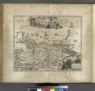
Venezuela, cum parte Australi Novae Andalusiae. [Karte], in: Gerardi Mercatoris et I. Hondii Newer Atlas, oder, Grosses Weltbuch, Bd. 2, S. 401.
1 Karte aus Atlas Mercator, Gerhard und Hondius, Jodocus Jansson, Jan
Venezuela, cum parte Australi Novae Andalusiae. [Karte], in: Novus Atlas, das ist, Weltbeschreibung, Bd. 2, S. 337.
1 Karte aus Atlas Blaeu, Joan Blaeu, Willem Janszoon

Venezuela, cum parte Australi Novae Andalusiae. [Karte], in: Theatrum orbis terrarum, sive, Atlas novus, Bd. 2, S. 343.
1 Karte aus Atlas Blaeu, Joan Blaeu, Willem Janszoon
Mapa de Venezuela ... guerra de independencia.
1 : 5300000 Codazzi, Agustin, 1793-1859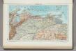
226. Venezuela, North. The World Atlas.
1 : 3750000 USSR (Union of Soviet Socialist Republics).
Venezuela, cum parte Australi Novae Andalusiae. [Karte], in: Novus atlas absolutissimus, Bd. 6, S. 237.
1 Karte aus Atlas Janssonius Offizin
Nieuwe Carybsche Pascaart: The Carybes Ilands [Karte], in: De Nieuwe Groote Vermeerderde Zee-Atlas ofte Water-Werelt, S. 65.
1 Karte aus Atlas Doncker, Hendrick
VENEZVELA, | cum parte Australi | NOVÆ ANDALVSIÆ
[Amsterdam : Joan Blaeu]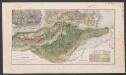
Venezuela, cum parte Australi Novae Andalusiae. [Karte], in: Le théâtre du monde, ou, Nouvel atlas contenant les chartes et descriptions de tous les païs de la terre, Bd. 2, S. 332.
1 Karte aus Atlas Blaeu, Willem Janszoon und Blaeu, Joan Blaeu, Willem Janszoon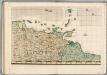
A Map of the British Empire in America. (Sheet 20).
1 : 2000000 Popple, Henry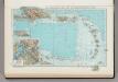
181. Haiti, Dominican Republic, Jamaica, Puerto Rico Island, Lesser Antilles, Trinidad and Tobago, Panama Canal (West Indies). The World Atlas.
1 : 3750000 USSR (Union of Soviet Socialist Republics).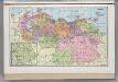
Venezuela.
1 : 3743000 Hammond, C.S.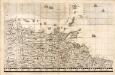
A Map of the British Empire in America. (Sheet 19).
1 : 2000000 Popple, Henry
Castille d' Or
“Castille D'Or”, es uno de los mapas impresos más pequeños del siglo XVII sobre los territorios de las actuales Panamá, Colombia y Venezuela. También fue uno de los que probablemente más circuló entre la población europea por ser parte de uno de los atlas de bolsillo más popular y económico de su tiempo. Duval, P. (Pierre) (1619-1683)
Der Orenoco
Orinoko-oblast (Venezulea a Kolumbie) Löwenberg, J. J. Löwenberg
Terra Firma
Mapa de Tierra Firme que proviene de uno de los más raros y apetecidos atlas en miniatura del siglo XVII. El texto al inferior del mapa identifica regiones con su respectiva ciudad principal: 1) Audiencia de Panamá, Panamá. 2) Provincia de Popayán, Antequera. 3) Cartagena, Cartagena. 4) Santa Marta, Santa Marta. 5) Rio del Hacha, Rio del Hacha. 6) Venezuela, Venezuela. 7) Granada, Bogotá. 8) Paria, Tamara. 9) Nueva Andalucía, Cumaná. Müller, Johann Ulrich (1653-1715) Bodenehr, Gabriel Kühn, Georg Wilhelm (fl. 1679-1717)
A new and improved chart of the West India or Carribbee [sic] Islands
1 : 1235000 Heather, W. (William) Heather, W. (William)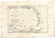
Les Petites Antilles ou les Isles du Vent avec celles de Sous le Vent
1 : 7320000 Malé Antily (souostroví) Bonne, Rigobert André
Facsimile: Part of Venezuela, Guiana by Arrowsmith.
1 : 4850000 Arrowsmith, John
Insula S.Iuan de Puerto Rico Caribes; Vel Canibalum Insulae. [Karte], in: Novus atlas absolutissimus, Bd. 9, S. 76.
1 Karte aus Atlas Janssonius Offizin