Maps of City of Pag

Pago.
from Spezialkarte der osterreichisch-ungarischen Monarchie.
Zone 28, Kol. XII, Pago, uit: Geologische Karte der im Reichsrathe vertretenen Königreiche und Länder der Österreich-Ungarischen Monarchie : auf Grundlage der Specialkarte i.M. 1:75.000 des k.u.k. Militär-geographischen Institutes / neu bearb. und als Kartenwerk von 341 Blattnummern in zwanglosen Lfg. hrsg. durch die k.k. Geologische Reichsanstalt in Wien
1 : 75000 titelvariant: Geologische Spezialkarte der im Reichsrate vertretenen Königreiche und Länder der Österreichisch-Ungarischen Monarchie; Geologische Specialkarte der im Reichsrathe vertretenen Königreiche und Länder der Österreichisch-Ungarischen Monarchie; Annotatie: Titel bovenaan kaartblad: Geologische Spezialkarte der im Reichsrate vertretenen Königreiche und Länder der Österreichisch-Ungarischen Monarchie en Geologische Specialkarte der im Reichsrathe vertretenen Königreiche und Länder der Österreichisch-Ungarischen Monarchie; Annotatie geografische gegevens: Coördinaten gebaseerd op nulmeridiaan van Ferro (Hierro) Kaiserlich-Königliche Geologische Reichsanstalt, Wenen Wien : K.K. Geologische Reichsanstalt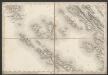
[Umgebung von Olib]
Kroatien Dalmatien Olib (Insel) Umland
Porto St. Pedro
Croatia Gerard van Keulen
Dioecesis Iadrensis
1 : 1850000 Diözese Zadar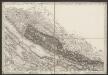
[Umgebung von Starigrad-Paklenica]
Kroatien Dalmatien Bezirk Zadar-Knin Umland
Karlobag und Jablanac.
from Spezialkarte der osterreichisch-ungarischen Monarchie.
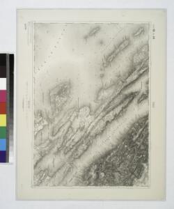
Zara.
from Spezialkarte der osterreichisch-ungarischen Monarchie.
Zone 29, Kol. XII, Zara, uit: Geologische Karte der im Reichsrathe vertretenen Königreiche und Länder der Österreich-Ungarischen Monarchie : auf Grundlage der Specialkarte i.M. 1:75.000 des k.u.k. Militär-geographischen Institutes / neu bearb. und als Kartenwerk von 341 Blattnummern in zwanglosen Lfg. hrsg. durch die k.k. Geologische Reichsanstalt in Wien
1 : 75000 titelvariant: Geologische Spezialkarte der im Reichsrate vertretenen Königreiche und Länder der Österreichisch-Ungarischen Monarchie; Geologische Specialkarte der im Reichsrathe vertretenen Königreiche und Länder der Österreichisch-Ungarischen Monarchie; Annotatie: Titel bovenaan kaartblad: Geologische Spezialkarte der im Reichsrate vertretenen Königreiche und Länder der Österreichisch-Ungarischen Monarchie en Geologische Specialkarte der im Reichsrathe vertretenen Königreiche und Länder der Österreichisch-Ungarischen Monarchie; Annotatie geografische gegevens: Coördinaten gebaseerd op nulmeridiaan van Ferro (Hierro) Kaiserlich-Königliche Geologische Reichsanstalt, Wenen Wien : K.K. Geologische Reichsanstalt
Die adriatische Küste von Pola bis Zara
1 : 900000 Kroatien Adriaküste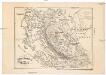
Ostrovy Quarnerské a Velebit
1 : 913000 Dalmácie (Chorvatsko)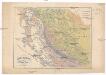
Ostrovy Quarnerské a Velebit
1 : 913000 Dalmácie (Chorvatsko)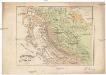
Ostrovy Quarnerské a Velebit
1 : 913000 Dalmácie (Chorvatsko)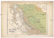
Ostrovy Quarnerské a Velebit
1 : 913000 Dalmácie (Chorvatsko)
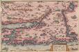
Iadera, Sicum et Aenona Vulgo Zara, Sibenico et Nona cum Insulis adiacentibus. in Parte Dalmatiae Boreali. [Karte], in: Het vijfde Deel Des Grooten Atlas : Vervatende De Water-Weereld, S. 234.
1 Karte aus Atlas Jansson, Jan Jansson, Jan
Iadera, Sicum et Aenona Vulgo Zara, Sibenico et Nona cum Insulis adjacentibus. in Parte Dalmatiae Boreali. [Karte], in: Novus atlas absolutissimus, Bd. 9, S. 314.
1 Karte aus Atlas Janssonius Offizin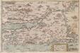
Zarae, et Sebenici Descriptio
Zadar (Region) Lazius, Wolfgang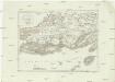
Westlicher Theil von Dalmatien
1 : 450000 Chorvatsko Santini, P. Engelman, J. W. F. A. Schraembl
Westlicher Theil von Dalmatien
1 : 445000 Chorvatsko Santini, P. Engelman, J. W. F. A. Schraembl
Karte vom Liccaner Grenz Regiment
1 : 105000 Chorvatsko Kossovich, Mathias Kaiser, J.F.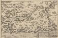
Zarae, Et Sebenici Descriptio [Karte], in: Theatrum orbis terrarum, S. 357.
1 Karte aus Atlas Ortelius, Abraham Vrients, Jan Baptista
Oesterreichische Riviera
Zarae, Et Sebenici Descriptio [Karte], in: Theatrum orbis terrarum, S. 262.
1 Karte aus Atlas Ortelius, Abraham
Generalkarte von Zentraleuropa

Adriatisches Meer, Küsten-Karte
1 : 180000 Istrijský poloostrov (Slovinsko a Chorvatsko) Oesterreicher, Tobias von Hydrographisches Amt der k. u. k. Kriegs-Marine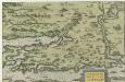
Zarae, Et Sebenici Descriptio
Mollova mapová sbírka Lazius, Wolfgang
Adriatisches Meer, Küstenkarte
1 : 180000 Dugi Otok (Chorvatsko : ostrov) Oesterreicher, Tobias von Hydrographisches Amt der k. u. k. Kriegsmarine
Selve.
from Spezialkarte der osterreichisch-ungarischen Monarchie.
Zone 27, Col. XII, Carlopago und Jablanac, uit: Geologische Karte der im Reichsrathe vertretenen Königreiche und Länder der Österreich-Ungarischen Monarchie : auf Grundlage der Specialkarte i.M. 1:75.000 des k.u.k. Militär-geographischen Institutes / neu bearb. und als Kartenwerk von 341 Blattnummern in zwanglosen Lfg. hrsg. durch die k.k. Geologische Reichsanstalt in Wien
1 : 75000 titelvariant: Geologische Spezialkarte der im Reichsrate vertretenen Königreiche und Länder der Österreichisch-Ungarischen Monarchie; Geologische Specialkarte der im Reichsrathe vertretenen Königreiche und Länder der Österreichisch-Ungarischen Monarchie; Annotatie: Titel bovenaan kaartblad: Geologische Spezialkarte der im Reichsrate vertretenen Königreiche und Länder der Österreichisch-Ungarischen Monarchie en Geologische Specialkarte der im Reichsrathe vertretenen Königreiche und Länder der Österreichisch-Ungarischen Monarchie; Annotatie geografische gegevens: Coördinaten gebaseerd op nulmeridiaan van Ferro (Hierro) Kaiserlich-Königliche Geologische Reichsanstalt, Wenen Wien : K.K. Geologische Reichsanstalt