Maps of Lika-Senj County
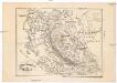
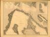
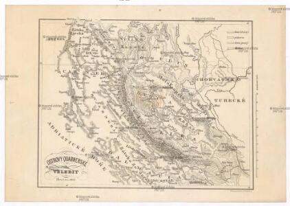
Ostrovy Quarnerské a Velebit
1 : 913000 Dalmácie (Chorvatsko)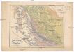
Ostrovy Quarnerské a Velebit
1 : 913000 Dalmácie (Chorvatsko)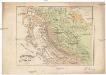
Ostrovy Quarnerské a Velebit
1 : 913000 Dalmácie (Chorvatsko)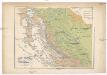
Ostrovy Quarnerské a Velebit
1 : 913000 Dalmácie (Chorvatsko)
Partie de la Dalmatie du nord ouest
Dalmácie (Chorvatsko) im Verlage des Kunst und Industrie Comptoirs
Charte des nordwestlichen Theil von Dalmatien
Dalmácie (Chorvatsko) Verlage der Kunst und Industrie
Charte des nordwestlichen Theiles von Dalmatien
Dalmácie (Chorvatsko) im Verlage des Kunst und Industrie Comptoirs
Die adriatische Küste von Pola bis Zara
1 : 900000 Kroatien Adriaküste
Adriatisches Meer, Küsten-Karte
1 : 180000 Istrijský poloostrov (Slovinsko a Chorvatsko) Oesterreicher, Tobias von Hydrographisches Amt der k. u. k. Kriegs-Marine
Grenzgebiet von Zagrabiensis und Corbaviensis
1 : 1850000 Diözese Krbava, Diözese Zagreb, Grenze
Generalkarte von Zentraleuropa

Karte vom Liccaner Grenz Regiment
1 : 105000 Chorvatsko Kossovich, Mathias Kaiser, J.F.
Physikalische Karte des Quarnero nach Dr. J. R. Lorenz
1 : 580000 Kroatien, Kvarner Freytag, Gustav
Senj
1 : 200000 Kartografska radionica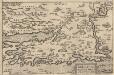
Zarae, Et Sebenici Descriptio [Karte], in: Theatrum orbis terrarum, S. 357.
1 Karte aus Atlas Ortelius, Abraham Vrients, Jan Baptista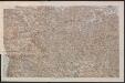
Übersicht des Feldzuges 35 v. Chr.
1 : 200000 Südosteuropa Illyrien Feldzug Augustus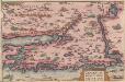
Zarae, Et Sebenici Descriptio [Karte], in: Theatrum orbis terrarum, S. 262.
1 Karte aus Atlas Ortelius, Abraham
Istrien, Dalmatien
1 : 80000 Dalmácie (Chorvatsko) Oesterreicher, T. Hydrographisches Amt der K. u. k. Kriegsmarine, Seekartendepot
Brinje. Ledenica und Ostaria.
from Spezialkarte der osterreichisch-ungarischen Monarchie.
Umgebungen von Arbe
Kroatien Dalmatien Rab Umland
Veglia und Novi.
from Spezialkarte der osterreichisch-ungarischen Monarchie.
Cherso und Arbe.
from Spezialkarte der osterreichisch-ungarischen Monarchie.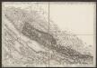
[Umgebung von Starigrad-Paklenica]
Kroatien Dalmatien Bezirk Zadar-Knin Umland
Senj und Otocac.
from Spezialkarte der osterreichisch-ungarischen Monarchie.
Lussinpiccolo und Punta Loni.
from Spezialkarte der osterreichisch-ungarischen Monarchie.
Karlobag und Jablanac.
from Spezialkarte der osterreichisch-ungarischen Monarchie.
Pago.
from Spezialkarte der osterreichisch-ungarischen Monarchie.
Selve.
from Spezialkarte der osterreichisch-ungarischen Monarchie.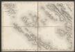
[Umgebung von Olib]
Kroatien Dalmatien Olib (Insel) Umland