Maps of Botosani

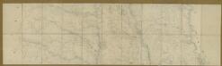
Uidestie.; Spezialkarte der osterreichisch-ungarischen Monarchie.
from Spezialkarte der osterreichisch-ungarischen Monarchie. Austro-Hungarian Monarchy. Militärgeographisches Institut.,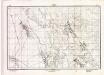
Lambert-Cholesky sheet 4479 (Corni)
1 : 20000 Romanian military topographic map sheet under Lambert-Cholensky projection Direcția Topografică Militară geo-spatial.org Direcția Topografică Militară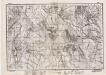
Lambert-Cholesky sheet 4579 (Cristeşti)
1 : 20000 Romanian military topographic map sheet under Lambert-Cholensky projection Direcția Topografică Militară geo-spatial.org Direcția Topografică Militară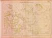
Lambert-Cholesky sheet 4478 (Liteni)
1 : 20000 Romanian military topographic map sheet under Lambert-Cholensky projection Serviciul Geografic al Armatei geo-spatial.org Serviciul Geografic al Armatei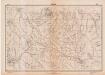
Lambert-Cholesky sheet 4578 (Oneaga)
1 : 20000 Romanian military topographic map sheet under Lambert-Cholensky projection Direcția Topografică Militară geo-spatial.org Direcția Topografică Militară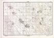
Lambert-Cholesky sheet 4480 (Vlădeni)
1 : 20000 Romanian military topographic map sheet under Lambert-Cholensky projection Direcția Topografică Militară geo-spatial.org Direcția Topografică Militară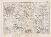
Lambert-Cholesky sheet 4580 (Botoşani)
1 : 20000 Romanian military topographic map sheet under Lambert-Cholensky projection Direcția Topografică Militară geo-spatial.org Direcția Topografică Militară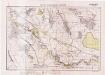
Lambert-Cholesky sheet 4379 (Burdujeni)
1 : 20000 Romanian military topographic map sheet under Lambert-Cholensky projection Serviciul Geografic al Armatei geo-spatial.org Serviciul Geografic al Armatei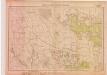
Lambert-Cholesky sheet 4378 (Pleşeni)
1 : 20000 Romanian military topographic map sheet under Lambert-Cholensky projection Serviciul Geografic al Armatei geo-spatial.org Serviciul Geografic al Armatei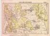
Lambert-Cholesky sheet 4380 (Hănteşti)
1 : 20000 Romanian military topographic map sheet under Lambert-Cholensky projection Serviciul Geografic al Armatei geo-spatial.org Serviciul Geografic al Armatei
Harta Cailor de Comunicatie din Judetul Botosani
Rumänien Judeţ Botoşani Verkehrsweg
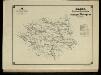
Harta Cailor de Comunicatie din Judetul Dorohoi
Rumänien Judeţ Dorohoi Verkehrsweg
Suczawa.
from Spezialkarte der osterreichisch-ungarischen Monarchie.
Czernowitz
1 : 400000 Instytut wojskowo-geograficzny
G. Freytags Karte der Bukowina
1 : 400000 Bukovina (Rumunsko a Ukrajina) Freytag, Gustav Kartogr. Anstalt G. Freytag & Berndt
G. Freytags Karte der Bukowina
1 : 400000 Bukovina (Rumunsko a Ukrajina) Freytag, Gustav G. Freytag & Berndt
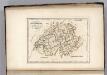
[Bodolien, Moldawien]
1 Karte : Kupferdruck ; 18 x 13 cm [Trattner]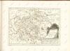
Carte de la Moldavie
1 : 330000 Moldawien, Bessarabien
Kolozsvár (Klausenburg), Máramaros-Sziget, Tölgyes
1 : 750000 Cluj-Napoca (Rumunsko) Erben, F. K. u. k. Militärgeographisches Institut
Kolozsvár (Klausenburg), Máramaros-Sziget, Tölgyes
1 : 750000 Cluj-Napoca (Rumunsko) Erben, F. K. u. k. Militärgeographisches Institut
Klausenburg, Máramaros-Sziget, Tölgyes
1 : 750000 K. u. k. militär-geographisches Institut
Klausenburg, Máramaros-Sziget, Tölgyes
1 : 750000 Cluj-Napoca (Rumunsko) K. k. militär-geographisches Institut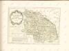

Generalkarte Von Siebenbürgen. Nach geometrisch gemessenen Karten und andern zuverlaessigen Hilfsmitteln verjüngt, und graduirt von Herrn A. von Wenzely. Herausgegeben von Herrn F. A. Schraembl
1 : 430000 Siebenbürgen Produkt, Straßennetz Wenzely, Anton; Schraembl, Franz Anton
Übersichtskarte von Mittel - Europa
Switzerland.
1 : 1500000 Carey, Mathew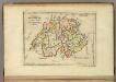
Switzerland.
1 : 1450000 Carey, Mathew
Switzerland.
1 : 1500000 Carey, Mathew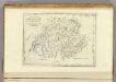
Switzerland.
1 : 500000 Carey, Mathew


