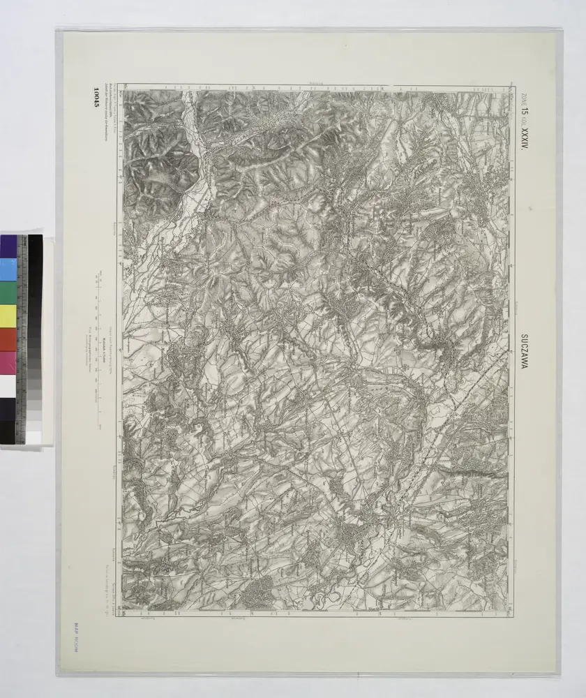
Maps of Suceava

Maps of Suceava

$title$

Suczawa.

from Spezialkarte der osterreichisch-ungarischen Monarchie.
$title$

Zu Bildner des Heeres Beilage 22

Suceava (Rumunsko) K.k. Schulbücher-Verschleiss-Administration
$title$

Lambert-Cholesky sheet 4280 (Hatna)

1 : 20000 Romanian military topographic map sheet under Lambert-Cholensky projection Serviciul Geografic al Armatei geo-spatial.org Serviciul Geografic al Armatei
$title$

Lambert-Cholesky sheet 4279 (Iţcani)

1 : 20000 Romanian military topographic map sheet under Lambert-Cholensky projection Serviciul Geografic al Armatei geo-spatial.org Serviciul Geografic al Armatei
$title$

Lambert-Cholesky sheet 4278 (Horodniceni)

1 : 20000 Romanian military topographic map sheet under Lambert-Cholensky projection Serviciul Geografic al Armatei geo-spatial.org Serviciul Geografic al Armatei
$title$

Lambert-Cholesky sheet 4180 (Arbora)

1 : 20000 Romanian military topographic map sheet under Lambert-Cholensky projection Serviciul Geografic al Armatei geo-spatial.org Serviciul Geografic al Armatei
$title$

Lambert-Cholesky sheet 4179 (CACICA)

1 : 20000 Romanian military topographic map sheet under Lambert-Cholensky projection Serviciul Geografic al Armatei geo-spatial.org Serviciul Geografic al Armatei
$title$

Lambert-Cholesky sheet 4178 (Gura Humorului)

1 : 20000 Romanian military topographic map sheet under Lambert-Cholensky projection Serviciul Geografic al Armatei geo-spatial.org Serviciul Geografic al Armatei
$title$

Lambert-Cholesky sheet 4177 (MANASTIREA SLATINA)

1 : 20000 Romanian military topographic map sheet under Lambert-Cholensky projection Institutul Geografic al Armatei geo-spatial.org Institutul Geografic al Armatei
$title$

Lambert-Cholesky sheet 4277 (Mălinii)

1 : 20000 Romanian military topographic map sheet under Lambert-Cholensky projection Serviciul Geografic al Armatei geo-spatial.org Serviciul Geografic al Armatei
$title$

Lambert-Cholesky sheet 4378 (Pleşeni)

1 : 20000 Romanian military topographic map sheet under Lambert-Cholensky projection Serviciul Geografic al Armatei geo-spatial.org Serviciul Geografic al Armatei
$title$

Lambert-Cholesky sheet 4379 (Burdujeni)

1 : 20000 Romanian military topographic map sheet under Lambert-Cholensky projection Serviciul Geografic al Armatei geo-spatial.org Serviciul Geografic al Armatei
$title$

Lambert-Cholesky sheet 4380 (Hănteşti)

1 : 20000 Romanian military topographic map sheet under Lambert-Cholensky projection Serviciul Geografic al Armatei geo-spatial.org Serviciul Geografic al Armatei
$title$

Lambert-Cholesky sheet 4377 (Fălticeni)

1 : 20000 Romanian military topographic map sheet under Lambert-Cholensky projection Serviciul Geografic al Armatei geo-spatial.org Serviciul Geografic al Armatei
$title$

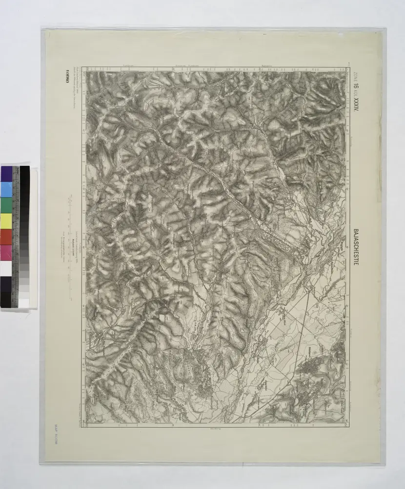
Bajaschestie.; Spezialkarte der osterreichisch-ungarischen Monarchie.

from Spezialkarte der osterreichisch-ungarischen Monarchie. Austro-Hungarian Monarchy. Militärgeographisches Institut.,
$title$

Lambert-Cholesky sheet 4080 (Solca)

1 : 20000 Romanian military topographic map sheet under Lambert-Cholensky projection Serviciul Geografic al Armatei geo-spatial.org Serviciul Geografic al Armatei
$title$

Lambert-Cholesky sheet 4079 (Poiana Micului)

1 : 20000 Romanian military topographic map sheet under Lambert-Cholensky projection Institutul Geografic al Armatei geo-spatial.org Institutul Geografic al Armatei
$title$

Lambert-Cholesky sheet 4078 (VAMA)

1 : 20000 Romanian military topographic map sheet under Lambert-Cholensky projection Serviciul Geografic al Armatei geo-spatial.org Serviciul Geografic al Armatei
$title$

Lambert-Cholesky sheet 4281 ( Şerbǎuţi)

1 : 20000 Romanian military topographic map sheet under Lambert-Cholensky projection Serviciul Geografic al Armatei geo-spatial.org Serviciul Geografic al Armatei
$title$

Lambert-Cholesky sheet 4381 (Vatra)

1 : 20000 Romanian military topographic map sheet under Lambert-Cholensky projection Serviciul Geografic al Armatei geo-spatial.org Serviciul Geografic al Armatei
$title$

Lambert-Cholesky sheet 4181 (Rădăuţi)

1 : 20000 Romanian military topographic map sheet under Lambert-Cholensky projection Serviciul Geografic al Armatei geo-spatial.org Serviciul Geografic al Armatei
$title$

Bukowina oder oestreich'scher Antheil der Moldau

1 : 580000 Bukovina (Rumunsko a Ukrajina) Küstel, Aloys J. Mare, Carl Gleditsch
$title$

G. Freytags Karte der Bukowina

1 : 400000 Bukovina (Rumunsko a Ukrajina) Freytag, Gustav Kartogr. Anstalt G. Freytag & Berndt
$title$

G. Freytags Karte der Bukowina

1 : 400000 Bukovina (Rumunsko a Ukrajina) Freytag, Gustav G. Freytag & Berndt
$title$

$title$

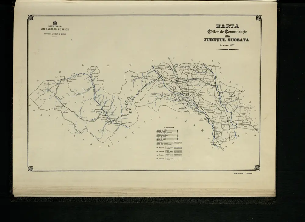
Harta Cailor de Comunicatie din Judetul Suceava

Rumänien Judet Suceava Verkehrsweg
$title$

$title$

Harta Cailor de Comunicatie din Judetul Botosani

Rumänien Judeţ Botoşani Verkehrsweg
$title$

Harta Cailor de Comunicatie din Judetul Dorohoi

Rumänien Judeţ Dorohoi Verkehrsweg
$title$

Radautz.; Spezialkarte der osterreichisch-ungarischen Monarchie.

from Spezialkarte der osterreichisch-ungarischen Monarchie. Austro-Hungarian Monarchy. Militärgeographisches Institut.,
© MapTiler © OpenStreetMap contributors
How does it work?
These instructions will show you how to find historical maps online.
Getting started
Type the place name in the search box to find the exact location. You can further adjust the search by zooming in and out.
Zoom
Zoom in and out with the buttons or use your mouse or touchpad natively.
Exact Area tool
Click here and draw a rectangle over the map to precisely define the search area.
Set filters
Narrow your search with advanced settings, such as Years (from/to), Fulltext, Publisher, etc.
Results
See the results of your search on the right side. You can scroll down to find more maps of this location.
?

Download OldMapsOnline Mobile