Maps of Braunau am Inn

Mattighofen.
from Spezialkarte der osterreichisch-ungarischen Monarchie.
Mappa Specialissima oder Privat-Karten, allein Vorstellend den Pfarr Umfang des I. Closters Sane
1 : 85000 Mollova mapová sbírka Seutter, Matthäus Seutter, Matthäus
Oberndorf
1 : 25000 Kartographisches Institut
Oberndorf
1 : 25000 Kartographisches Institut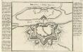
Braunau in Ober Bayern.
Mollova mapová sbírka Bodenehr, Gabriel Bodenehr, Gabriel
Straszwalchen
1 : 25000 Kartographisches Institut
Oberndorf
1 : 25000 Hauptvermessungsabteilung XIV
Anthering
1 : 25000 Kartographisches Institut
Anthering
1 : 25000 Kartographisches Institut
Anthering
1 : 25000 Kartographisches Institut
Seekirchen
1 : 25000 Hauptvermessungsabteilung XIV
Frankenmart
1 : 25000 Kartographisches Institut
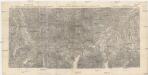
Das Inn Viertel in dem Erzherzogthum Oesterreich ob der Enns
1 : 170000 Augsburg : Tobias Conrad Lotter
Salzburg
1 : 200000 Herder, Benjamin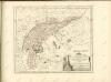

Salzburg 144, uit: Special-Karte von Mittel-Europa / nach amtlichen Quellen bearbeitet von W. Liebenow
1 : 300000 titelvariant: W. Liebenow's Mittel-Europa; Annotatie: Titel boven de bladen: W. Liebenow's Mittel-Europa Johannes Wilhelm Liebenow 1822-1897 Frankfurt a. M. : Ludwig Ravenstein
Das Inn Viertel in dem Erzherzogthum Oesterreich ob der Enns
1 : 230000 Horní Rakousko (Rakousko) Balzer, Řehoř Anton Elsenwanger
Das Inn Viertel in dem Erzherzogthum Oesterreich ob der Enns
1 : 230000 Bavorsko (Německo) Balzer, Řehoř Anton Elsenwanger
Das Inn Viertel in dem Erzherzogthum Oesterreich ob der Enns
1 : 230000 Bavorsko (Německo) Balzer, Řehoř Anton Elsenwanger
Das Inn Viertel in dem Erzherzogthum Oesterreich ob der Enns
1 : 170000 Horní Rakousko (Rakousko) Lotter, Tobias Conrad Tobias Conrad Lotter
Neuer Siegreicher Plan der königl. Hungar; und Böhm. victoriosen Action welche den 9. May Ano. 1743 bey Braunau vorgefallen, sambt allen von 6ten biß 14. May vorbeygegangenen Operationen
Mollova mapová sbírka Lidl, Johann Jakob Lidl, Johann Jacob
182. Burghausen, uit: Topographische Uebersichtskarte des Deutschen Reiches / herausgegeben v. d. Kartogr. Abt. d. Königl. Preuß. Landesaufnahme
1 : 200000 titelvariant: Topogr. Übersichtskarte des Deutschen Reiches; Annotatie: Titel boven bladen ook: Topogr. Übersichtskarte des Deutschen Reiches; Annotatie geografische gegevens: Op elk blad twee maatstokken: 10 Kilometer = 5,5 cm; 1 geogr. Meile = 3,6 cm; Legenda onder op elk blad Königlich Preußische Landesaufnahme. Kartographische Abtheilung [S.l : Königlich Preußische Landesaufnahme, Kartographische Abtheilung]
Theil von Bayern
Bavorsko (Německo) Streit, Friedrich Wilhelm Geograph. Institut
Das Hoch-Fürstl: Erzstifft Salzburg sambt Angräntzenden Orthen
1 : 1600000 Mollova mapová sbírka Seutter, Matthäus Seutter, Matthäus
Pars IX. prodit partem Bavariæ sup: versus orientem et meridiem sitam ad Salam, Saltzam et Riv: Mattich, archiep: Salisburg. cum oris archiducat Austriæ super
1 Karte : 54 x 52 cm Heinrich Ludwig Broenner
Salzburg.
1 : 462000 Radefeld, Carl Christian Franz, 1788-1874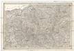
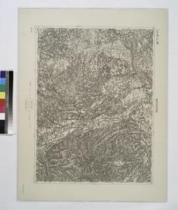
[Umgebungen von Ried]
David, J.
Archiducatus Austriae Superioris Geographica Descriptio. facta Anno 1667
1 : 150000 Mollova mapová sbírka Vischer, Georg Matthaeus Küssel, Melchior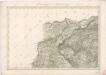
Umgebungen von Dittmoning