Maps of Ried im Innkreis
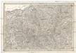
[Umgebungen von Ried]
David, J.
Theil von Bayern
Bavorsko (Německo) Streit, Friedrich Wilhelm Geograph. Institut
Archiducatus Austriae Superioris Geographica Descriptio. facta Anno 1667
1 : 150000 Mollova mapová sbírka Vischer, Georg Matthaeus Küssel, Melchior
Reid und Vocklabruck.
from Spezialkarte der osterreichisch-ungarischen Monarchie.
Archiducatus Austriae Superioris Geographica Descriptio. facta Anno 1667
1 : 150000 Mollova mapová sbírka Vischer, Georg Matthaeus Küssel, Melchior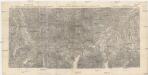
Special-Karte für die Schluss-Manöver des 14. Corps 1890
1 : 75000 Horní Rakousko (Rakousko) K. u. k. militär-geographisches Institut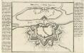
Braunau in Ober Bayern.
Mollova mapová sbírka Bodenehr, Gabriel Bodenehr, Gabriel
Austriae Archiducatus Superioris in suas Quadrantes Ditiones exacte divisi accuratissima Tabula
1 : 330000 Mollova mapová sbírka Vischer, Georg Matthaeus Homann, Johann Baptista
Austriae Archiducatus Superioris in suas Quadrantes Ditiones exacte divisi accuratißima Tabula
1 : 330000 Mollova mapová sbírka Vischer, Georg Matthaeus Homann, Johann Baptista
Nova Mappa Archiducatus Austriae Superioris Ditiones in suas Quadrantes divisas conspectui listens iuxta recentissimas observation adornata
1 : 330000 Mollova mapová sbírka Seutter, Matthäus Seutter, Matthäus
Avstria Svperior secundum IIII. Quadrantes & regiones contiguas
1 : 330000 Mollova mapová sbírka Weigel, Christoph Seutter, Matthäus
Austriae Archiducatus Pars Superior in omnes ejusdem Quadrantes Ditiones accuratissime ét distincté delineata
1 : 330000 Mollova mapová sbírka Vischer, Georg Matthaeus Vischer, Peter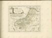

Salzburg
1 : 200000 Herder, Benjamin
Das Inn Viertel in dem Erzherzogthum Oesterreich ob der Enns
1 : 170000 Augsburg : Tobias Conrad Lotter
Das Inn Viertel in dem Erzherzogthum Oesterreich ob der Enns
1 : 230000 Horní Rakousko (Rakousko) Balzer, Řehoř Anton Elsenwanger
Das Inn Viertel in dem Erzherzogthum Oesterreich ob der Enns
1 : 230000 Bavorsko (Německo) Balzer, Řehoř Anton Elsenwanger
Das Inn Viertel in dem Erzherzogthum Oesterreich ob der Enns
1 : 230000 Bavorsko (Německo) Balzer, Řehoř Anton Elsenwanger
Das Inn Viertel in dem Erzherzogthum Oesterreich ob der Enns
1 : 170000 Horní Rakousko (Rakousko) Lotter, Tobias Conrad Tobias Conrad Lotter
183. Neuhaus (a. Inn.), uit: Topographische Uebersichtskarte des Deutschen Reiches / herausgegeben v. d. Kartogr. Abt. d. Königl. Preuß. Landesaufnahme
1 : 200000 titelvariant: Topogr. Übersichtskarte des Deutschen Reiches; Annotatie: Titel boven bladen ook: Topogr. Übersichtskarte des Deutschen Reiches; Annotatie geografische gegevens: Op elk blad twee maatstokken: 10 Kilometer = 5,5 cm; 1 geogr. Meile = 3,6 cm; Legenda onder op elk blad Königlich Preußische Landesaufnahme. Kartographische Abtheilung [S.l : Königlich Preußische Landesaufnahme, Kartographische Abtheilung]
Archiducatus Austriae Superioris Geographica Descriptio. facta Anno 1667
1 : 150000 Mollova mapová sbírka Vischer, Georg Matthaeus Küssel, Melchior
Salzburg.
1 : 462000 Radefeld, Carl Christian Franz, 1788-1874
Mattighofen.
from Spezialkarte der osterreichisch-ungarischen Monarchie.
Bairische Landtafeln XXIIII. Darinnē das hochlöblich Furstenthumb Obern unnd Nidern Bayrn sambt der Obern Pflaz Erz unnd Stifft Salzburg Eichstet unnd andern mehrern anstossenden Herschafftē]
1 : 145000 Mollova mapová sbírka Apian, Philipp Amman, Jost Apian, Petrus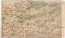
Strecke
Gmunden (Rakousko) K. k. Österreichische Staatsbahnen
Schading.; Spezialkarte der osterreichisch-ungarischen Monarchie.
from Spezialkarte der osterreichisch-ungarischen Monarchie. Austro-Hungarian Monarchy. Militärgeographisches Institut.,
Braunau und Triftern.
from Spezialkarte der osterreichisch-ungarischen Monarchie.
Steyrermühl
1 : 25000 Kartographisches Institut
Schörfling
1 : 25000 Horní Rakousko (Rakousko) Kartographisches Institut
![[Umgebungen von Ried]](https://images-2.georeferencer.com/images/iiif/254583127694/full/,300/0/native.jpg)

