Maps of Kamianka-Buzkyi District
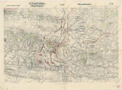
Störungsfeuerskizze

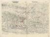
Lemberg.
from Spezialkarte der osterreichisch-ungarischen Monarchie.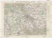
Mapa specjalna okolic Lwowa
1 : 100000 Lvov-oblast (Ukrajina) Książnica – Atlas
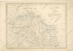
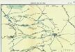
Busk und Krasne.
from Spezialkarte der osterreichisch-ungarischen Monarchie.
Busk und Krasne
1 : 75000 Ukrajina Fitz, J. K. u. k. Militärgeographisches Institut
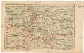
Kamionka Strumilowa.
from Spezialkarte der osterreichisch-ungarischen Monarchie.
Lemberg
1 : 75000 Lvov-oblast (Ukrajina) Scherling K. u. k. Militärgeographisches Institut
Nr. 6a. Kämpfe in Ostgalizien. Zwischen San und Bug
Galizien Weltkrieg <1914-1918>, Ostfront
Generalkarte von Zentraleuropa

Generalkarte von Zentraleuropa
Strecke
Ivano-Frankivsk (Ukrajina) K. k. Österreichische Staatsbahnen
Russia
Mollova mapová sbírka Hoffmann, Johannes Hoffmann, Johann
Ost Galizien
Halič (Polsko a Ukrajina) Liesganig, Joseph m Verlage des Kunst- und Industrie- Comptoirs
Tarnopol, Brody, Stryj, Czernowitz
1 : 750000 Brody (Ukrajina) Erben, F. K. u. k. Militärgeographisches Institut
Tarnopol, Brody, Stryj, Czernowitz
1 : 750000 Brody (Ukrajina) Erben, F. K. u. k. Militärgeographisches Institut
Tarnopol, Brody, Stryj, Czernowitz
1 : 750000 K. u. k. militär-geographisches Institut
Tarnopol, Brody, Stryj, Czernowitz
1 : 750000 Brody (Ukrajina) K. k. militär-geographisches Institut
Übrige Länder der ehemaligen Österreich-Ung. Monarchie
1 : 900000 Halič (Polsko a Ukrajina) Koch, Wilhelm Opitz, Carl Arnd
Carte de la Roumanie et pays limitrophes. Lemberg
1 : 500000 France. Service géographique de l'armée [Paris] : Service géographique de l'armée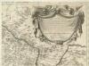
Augustissimo Romanor. Imperatori Iosepho I. Hungaria Regi Invictissimo Mappam Hanc Regni Hungariae
1 : 540000 Mollova mapová sbírka Müller, Johann Christoph
Galizien, Östlicher Theil und Bukowina
1 : 700000 Bukovina (Rumunsko a Ukrajina) Karl Fr. Pfau
Sheet V: Karte Des Oesterreichischen Kaiserstaates.
1 : 576000 Scheda, Josef
Bez titulu: Šest listů speciálních map Ukrajiny

Übersichtskarte von Mittel - Europa

Sbírka map a diagramů použitých na mírových konferencích v Paříži v letech 1919 - 1920

V, uit: General-Karte des oesterreichischen Kaiserstaates mit einem grossen Theile der angrenzenden Länder / durch Josef Scheda ... bearb. und hrsg
1 : 576000 Annotatie geografische gegevens: Maatstokken: oesterreichische Meilen, geografische oder deutsche Meilen, preussische Meilen, türkische Berri, französische Lieues, russische Werste; Maatstok per blad: wiener Klafter, öster. Meilen; Blad XIX: statistische en taalkundige informatie; Blad XIX: legenda [Wien : K.K. Militärisch-Geografisches Institut]
Pohlen, Rußland, Gallicien, Wolhinien, Podolien. Ungarn. Ungvárer Comitat
Ungarn Verkehrsweg
Strassen- und Eisenbahnkarte des oesterreichischen Kaiserthumes
1 : 864000 Blatt 4 Schaller, G. K.K. Militärisch-Geografisches Institut, Karten-Evidenthaltungs-Abteilung