Maps of Sud
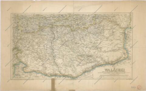
Die Walachei
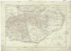
Topographische Karte der Grossen und Kleinen Wallachey
1 : 580000 Rumunsko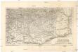
Die Walachei
1 : 800000 Valašsko (Rumunsko) Kiepert, Heinrich Hanemann, August Geographisches Institut
Generalcharte der Walachey
1 : 740000 Rumunsko Fried, Franz Kunst und Industrie Comptoir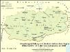
Verwaltungseinteilung im Gebiet der historischen Region Walachei bzw. im Süden Großrumäniens um 1930
Walachei Rumänien (Süd), Verwaltungsgliederung Zwick, J.
Die Walachei im 18./19. Jahrhundert
Walachei Städtenetz, Siedlung Zwick, J.
Carte der Wallachei
1 : 1000000 Valašsko (Rumunsko) Adam, Jakob
Carte der Besitznehmung der Wallachey von den K.K. Truppen unter Com.do des F.M. P. v. Sachsen Cobur
1 Karte : Kupferdruck ; 12 x 17 cm [Trattner]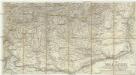
Die Walachei
1 : 800000 Valašsko (Rumunsko)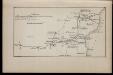
1809 god [Bukarest]
Rumänien Bukarest Russisch-Türkischer Krieg <1806-1812>
Nagyszeben (Hermannstadt), Brassó (Kronstadt), Bukarest, Craiova, Vidin, Rusčuk
1 : 750000 Brašov (Rumunsko : oblast) Korb, L. K. u. k. Militärgeographisches Institut
Hermannstadt, Kronstadt, Bukarest, Craiova, Vidin, Rusčuk
1 : 750000 Brašov (Rumunsko : oblast) K. k. militär-geographisches Institut
Bukuresti (Bukarest)
1 : 750000 Bukurešť (Rumunsko) Goldmann, R. K. u. k. Militärgeographisches Institut
Übersichtskarte von Mittel - Europa

J.7. Bucuresti (Bukarest), uit: [Übersichtskarte von Europa 1:750.000]
1 : 750000 Wien : K.u.K. Militärgeographisches Institut
Valachia.
1 : 1400000 Mollova mapová sbírka Bruggen, Johann van der Brugge, Johannes van der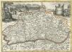
Valachia
1 : 1400000 Mollova mapová sbírka Pfeffel, Johann Andreas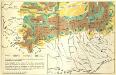
[Siebenbürgen : Weidewirtschaft]
Siebenbürgen Transhumanz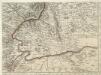
Augustissimo Romanor. Imperatori Iosepho I. Hungaria Regi Invictissimo Mappam Hanc Regni Hungariae
1 : 540000 Mollova mapová sbírka Müller, Johann Christoph
Strassen- und Eisenbahnkarte des oesterreichischen Kaiserthumes
1 : 864000 Blatt 12 Schaller, G. K.K. Militärisch-Geografisches Institut, Karten-Evidenthaltungs-Abteilung
Ungarn. Comit. Krassó, Zaránd. Walachei. Illyrien. Siebenbürgen. Comit: Hunyad, Kükülö, Unter- und Ober Weißenburger. Stühle: Dreystuhler, Repser, Schäßburg, Groß Schenker, Medjascher, Leschkirchner, Hermannstädter, Reißmärker, Mühlenbacher & Brooder Stuhl. Districte: Fogaras & Kronstadt
Ungarn Verkehrsweg
Carte de la Roumanie et pays limitrophes. Bukarest
1 : 500000 France. Service géographique de l'armée [Paris] : Service géographique de l'armée
Sheet XV: Karte Des Oesterreichischen Kaiserstaates.
1 : 576000 Scheda, Josef
XV, uit: General-Karte des oesterreichischen Kaiserstaates mit einem grossen Theile der angrenzenden Länder / durch Josef Scheda ... bearb. und hrsg
1 : 576000 Annotatie geografische gegevens: Maatstokken: oesterreichische Meilen, geografische oder deutsche Meilen, preussische Meilen, türkische Berri, französische Lieues, russische Werste; Maatstok per blad: wiener Klafter, öster. Meilen; Blad XIX: statistische en taalkundige informatie; Blad XIX: legenda [Wien : K.K. Militärisch-Geografisches Institut]
Bucure\0219ti
1 : 400000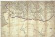
[Jižní Rumunsko]
Rumunsko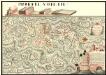
Plan der Batalie bei Beroschan in der Walachai samt den Drei Mahlichen Stvrm den 26. Jvli 1739
Mollova mapová sbírka Geyer