Maps of Sud
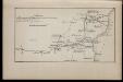
1809 god [Bukarest]
Rumänien Bukarest Russisch-Türkischer Krieg <1806-1812>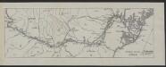
Obščaja karta Dunaja
Rumänien Donau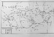
Die Walachei (14.-18. Jahrhundert)
Walachei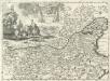
Regnum Bulgariae 1737
1 : 2200000 Mollova mapová sbírka Bruggen, Johann van der Brugge, Johannes van der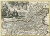
Regnum Bulgariae
1 : 2200000 Mollova mapová sbírka Pfeffel, Johann Andreas
Overzichtskaart van het Rumeensche oorlogstooneel
1 : 1500000 Annotatie geografische gegevens: De kaart toont spoorwegen in exploitatie en in aanleg [S.l. : Top. Inr.]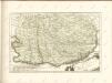

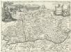
Carte der Wallachei
1 : 1000000 Valašsko (Rumunsko) Adam, Jakob
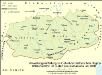
Verwaltungseinteilung im Gebiet der historischen Region Walachei bzw. im Süden Großrumäniens um 1930
Walachei Rumänien (Süd), Verwaltungsgliederung Zwick, J.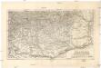
Die Walachei
1 : 800000 Valašsko (Rumunsko) Kiepert, Heinrich Hanemann, August Geographisches Institut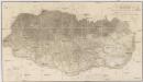
Topographische Karte der Grossen und Kleinen Wallachey
1 : 580000 Rumunsko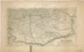
Die Walachei

Carte der Besitznehmung der Wallachey von den K.K. Truppen unter Com.do des F.M. P. v. Sachsen Cobur
1 Karte : Kupferdruck ; 12 x 17 cm [Trattner]
[Šumla]
Bulgarien Šumen Russisch-Türkischer Krieg <1806-1812>
Die Walachei im 18./19. Jahrhundert
Walachei Städtenetz, Siedlung Zwick, J.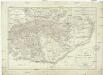
Generalcharte der Walachey
1 : 740000 Rumunsko Fried, Franz Kunst und Industrie Comptoir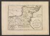
Des Koenigreichs Bulgarien Oestliche Haelfte
1 : 1200000 Bulgarien (Ost)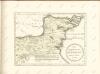
Valachia.
1 : 1400000 Mollova mapová sbírka Bruggen, Johann van der Brugge, Johannes van der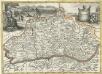
Valachia
1 : 1400000 Mollova mapová sbírka Pfeffel, Johann Andreas
Die Dobrudscha
Dobrudscha, Osmanisches Reich, Balkankriege Häusler, Ines
Übersichtskarte von Mittel - Europa

Galati. Medgidia. Ismail. Silistra. Balcic

Galaz, Medžidie, Ismail, Silistria, Balčik
1 : 750000 Balčik (Bulharsko) Budik, Ad. K. u. k. Militärgeographisches Institut
Galaz, Medžidie, Ismail, Silistria, Balčik
1 : 750000 Balčik (Bulharsko) K. k. militär-geographisches Institut
Nagyszeben (Hermannstadt), Brassó (Kronstadt), Bukarest, Craiova, Vidin, Rusčuk
1 : 750000 Brašov (Rumunsko : oblast) Korb, L. K. u. k. Militärgeographisches Institut
Hermannstadt, Kronstadt, Bukarest, Craiova, Vidin, Rusčuk
1 : 750000 Brašov (Rumunsko : oblast) K. k. militär-geographisches Institut
J.7. Bucuresti (Bukarest), uit: [Übersichtskarte von Europa 1:750.000]
1 : 750000 Wien : K.u.K. Militärgeographisches Institut
![1809 god [Bukarest]](https://images-2.georeferencer.com/images/iiif/592071298337/full/,300/0/native.jpg)

