Maps of Czech Republic

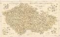
Protektorát Čechy a Morava

Čechy, Morava a Slezsko
Česko Wagner, Jan Eduard sklad Jaroslava Pospíšila
Poutní místa
Česko
Sbírka map a diagramů použitých na mírových konferencích v Paříži v letech 1919 - 1920

Mapa akadem. spolků a jejich knihovny
Česko Amler, J. Horák, F.
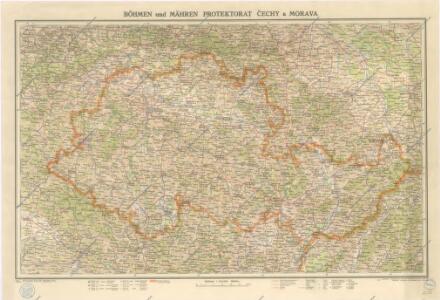
Protektorat Böhmen-Mähren
1 : 500000 Praha (Česko) Edvard Fastr
Mapa činnosti Ústřední matice škol v Praze v letech 1880-1930
1 : 770000 Praha (Česko : oblast) Hocke, Jan V. Neubert a synové
Čechy - Morava Příruční a cestovní mapa

Isotermy v zemi České a Moravskoslezské

Tschechische Republik 2001. Schlesier (slezská národnost)
Tschechische Republik ethnische Gruppe, Schlesier Hofinger, Veronika
Grossdeutsches Reich Sudetenländer

Železniční mapa Království českého
České království
Tschechische Republik 2001. Nationalitäten
Tschechische Republik ethnische Gruppe Hofinger, Veronika
Tschechische Republik 2001. Tschechen (česká národnost)
Tschechische Republik ethnische Gruppe, Tschechen Hofinger, Veronika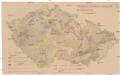
Mechanisch-physikalische Bodenkarte der Sudetenländer
1 : 750000 Česko Niethammer, A.
Vilímkovy místopisné mapy zemí Koruny České

Übersichtskarte des Protektorats Böhmen und Mähren
Soubor němých map pro střední školy

Tschechische Republik 2001. Deutsche (německá národnost)
Tschechische Republik ethnische Gruppe, Deutsche Hofinger, Veronika
Tschechische Republik 2001. Polen (polská národnost)
Tschechische Republik ethnische Gruppe, Polen Hofinger, Veronika
Mapa poněmčování zemí koruny České

Dr. A. Oberschall's Sprachenkarte der Tschechoslowakischen Republik.
Česko Oberschall, Albin Hocke, Jan Deutschpolitischen Arbeitsstelle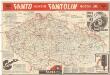
Mapa o stavu vozovek československých silnic
1 : 650000 Česko Autoklub RČS
Mapa o stavu vozovek československých silnic
1 : 650000 Česko Autoklub R.Č.S.
Tschechische Republik 2001. Slowaken (slovenská národnost)
Tschechische Republik ethnische Gruppe, Slowaken Hofinger, Veronika
Mapa doktorů a absolv. techniků s 2. stát. zkouškou od r. 1882-83 do 1892-93
Česko Horák, František Doležal, Bohumil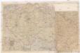
[Protektorát Čechy a Morava]
1 : 400000 Protektorát Čechy a Morava Machát, František
Viseci [sic] mapa Království českého
1 : 200000 Česko Kocen, Blaž Erben, Josef Eduarda Hölzel
Česká obec sokolská před vzplanutím světové války v r. 1914
1 : 170000 Dolní Rakousko (Rakousko) Musil, Ladislav V. Neubert