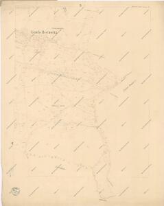
Maps of Borovnice

Stabilní katastr - Procovní otisk Gross Borowitz

Gross Borowitz (Hrubá Borowice) - c0396-1-001 - Kaiserpflichtexemplar der Landkarten des stabilen Katasters
1 : 2880
Gross Borowitz (Hrubá Borowice) - c0396-1-002 - Kaiserpflichtexemplar der Landkarten des stabilen Katasters
1 : 2880
Gross Borowitz (Hrubá Borowice) - c0396-1-003 - Kaiserpflichtexemplar der Landkarten des stabilen Katasters
1 : 2880
Gross Borowitz (Hrubá Borowice) - c0396-1-005 - Kaiserpflichtexemplar der Landkarten des stabilen Katasters
1 : 2880
Gross Borowitz (Hrubá Borowice) - c0396-1-004 - Kaiserpflichtexemplar der Landkarten des stabilen Katasters
1 : 2880
Klein Borowitz (Mala Borowice) - c0397-1-001 - Kaiserpflichtexemplar der Landkarten des stabilen Katasters
1 : 2880
Klein Borowitz (Mala Borowice) - c0397-1-003 - Kaiserpflichtexemplar der Landkarten des stabilen Katasters
1 : 2880
Klein Borowitz (Mala Borowice) - c0397-1-004 - Kaiserpflichtexemplar der Landkarten des stabilen Katasters
1 : 2880
Klein Borowitz (Mala Borowice) - c0397-1-002 - Kaiserpflichtexemplar der Landkarten des stabilen Katasters
1 : 2880
Stankau (Stankow) - c7227-1-002 - Kaiserpflichtexemplar der Landkarten des stabilen Katasters
1 : 2880
Stankau (Stankow) - c7227-1-001 - Kaiserpflichtexemplar der Landkarten des stabilen Katasters
1 : 2880
Hinter Zdirnitz (Zadnj Zdirnice) - c9033-1-001 - Kaiserpflichtexemplar der Landkarten des stabilen Katasters
1 : 2880
Hinter Zdirnitz (Zadnj Zdirnice) - c9033-1-002 - Kaiserpflichtexemplar der Landkarten des stabilen Katasters
1 : 2880
Vertretungsbezirk Arnau


Hohenelbe
1 : 75000 Krkonoše (Česko a Polsko : pohoří : oblast) Charlemont K. u. k. Militärgeographisches Institut
Hohenelbe
1 : 75000 Vrchlabí (Česko : oblast) K. u. k. Militärgeographisches Institut
Umgebung von Trautenau
1 : 75000 Trutnov (Česko : oblast) Militärgeographisches Institut
Uebersichtsblatt zum Kriegsspielplan der Umgebung von Trautenau

Uebersichtsblatt zum Kriegsspielplan der Umgebung von Trautenau

Umgebung von Jičín II.

Podrobná mapa Království českého
1 : 100000 Dvůr Králové nad Labem (Česko : oblast) Srp, Jan Jaroslav Bursík
Vilímkovy místopisné mapy zemí Koruny české
1 : 100000 Dvůr Králové nad Labem (Česko : oblast) Srp, Jan Jos. R. Vilímek
Mapa okresního hejtmanství Trutnovského

[Trautenau, Königinhof und Umgebung]
1 : 243000 Králův Dvůr (Česko)
Vilímkovy podrobné mapy politických okresů

Karte der Bezirkshauptmannschaften Hohenelbe und Starkenbach
Jilemnice-oblast (Česko) Erben, Josef Flemming, C. Karl Janský