Maps of Trutnov

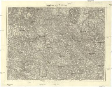
Umgebung von Trautenau
1 : 75000 Trutnov (Česko : oblast) Militärgeographisches Institut
Trutnov a okolí
1 : 75000 Trutnov (Česko : oblast) Vojenský zeměpisný ústav
Trutnov a okolí
1 : 75000 Trutnov (Česko : oblast) Vojenský zeměpisný ústav
Trutnov a okolí

Mapa okresního hejtmanství Trutnovského

Karte der Bezirkshauptmannschaft Trautenau
1 : 100000 Trutnov-oblast (Česko) Erben, Josef Karl Janský
Uebersichtsblatt zum Kriegsspielplan der Umgebung von Trautenau
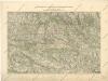
Uebersichtsblatt zum Kriegsspielplan der Umgebung von Trautenau

Mapa okresního hejtmanství Královédvorského
1 : 100000 Dvůr Králové nad Labem-oblast (Česko) Erben, Josef Flemming, C. nákladem Karla Janského
Úpice a okolí

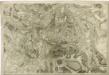
Neueste Wegekarte vom Riesengebirge und Situationsplan von Johannsbad
1 : 75000 Janské Lázně (Česko : oblast) Vatter, Alfred Alfred Vatter

Topographische und Militairische Carte desienigen Theils von Boehmen...

Trutnov
1 : 75000 Trutnov (Česko : oblast) Vojenský zeměpisný ústav
Trutnov
1 : 75000 Trutnov-oblast (Česko) Vojenský zeměpisný ústav
Trutnov
1 : 75000 Trutnov (Česko : oblast) Vojenský zeměpisný ústav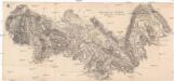
Gegend zwischen Schatzlar Golden-Else und Wekelsdorf
Žacléř-oblast (Česko)
Vertretungsbezirk Arnau

Plan des glückl. Treffens Sr. Königl. Maj. in Preussen den 30ten Sept. 1745 bey Sahr in Böhmen, Königin Graetzer Creÿss der Gegend Trautenau in einer accuraten Charte selbigen Terrains
1 : 110000 Mollova mapová sbírka Werner, Bedřich Bernard
Geologická mapa žacléřsko-svatoňovicko-žďáreckého uhelného revíru
1 : 75000 Žacléř-oblast (Česko) Sandtner, Boh. Hornicko-hutnické nakladatelství Prometheus
[Kartenblatt]
1 : 25000 Mladé Buky (Česko : oblast) Reichsamt für Landesaufnahme
III. vojenské mapování 3756/3
1 : 25000
Bez titulu: Soubor plánů – Prusko-Rakouská válka 1866

[Bitva u Trutnova 28. 6. 1866]
1 : 28800 Trutnov-oblast (Česko)
Plan für die Gefechte von Trautenau am 27. Juni und von Neu-Rognitz am 28. Juni 1866
1 : 28800 Trutnov-oblast (Česko)
Plan für die Gefechte von Trautenau am 27. Juni und von Neu-Rognitz am 28. Juni 1866
1 : 28800 Trutnov-oblast (Česko)
Plan für die Gefechte von Trautenau am 27. Juni und von Neu-Rognitz am 28. Juni 1866
1 : 28800 Trutnov-oblast (Česko)
Plan für die Gefechte von Trautenau am 27. Juni und von Neu-Rognitz am 28. Juni 1866
1 : 29000 Trutnov-oblast (Česko)
Plan des Gefechtsfeldes von Trautenau am 27 Juni 1866 und des Gefechtsfeldes von Soor am 28 Juni 1866
1 : 25000 Trutnov-oblast (Česko) Schmeling, von