Maps of Lázně Libverda

Situations Plan des graftlich Clam Gallassischen Badeortes Liebwerda...

Mildeneichen - c4326-2-003 - Kaiserpflichtexemplar der Landkarten des stabilen Katasters
1 : 2880
Mildeneichen - c4326-2-001 - Kaiserpflichtexemplar der Landkarten des stabilen Katasters
1 : 2880
Mildeneichen - c4326-2-002 - Kaiserpflichtexemplar der Landkarten des stabilen Katasters
1 : 2880
Meßtischblatt 5157 : Haindorf, 1942
1 : 250000 Haindorf. - Aufn. 1883, hrsg. 1884, bericht. 1924. - 1:25000. - [Berlin]: Reichsamt für Landesaufnahme, 1942. - 1 Kt.
III. vojenské mapování 3654/2, 3554/4
1 : 25000
III. vojenské mapování 3654/2
1 : 25000
III. vojenské mapování 3654/2, 3554/4
1 : 25000
[Kartenblatt]
1 : 25000 Hejnice-oblast (Liberec, Česko) Reichsamt für Landesaufnahme
III. vojenské mapování 3654/2, 3554/4
1 : 25000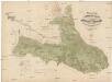
Uiberischts- und Bestandes-Karte des ersten Forstamtbezirkes der Herrschaft Friedland
1 : 29200 Frýdlant-oblast (Česko) Wunderlich, F. Verlag des böhm. Forstvereins
III. vojenské mapování 3654/2
1 : 25000

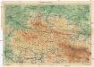
Bezirk Friedland

III. vojenské mapování 3654
1 : 75000
Reichenberg u. Friedland
1 : 75000 Frýdlant (Česko : oblast) Reichenauer K. u. k. Militärgeographisches Institut
Reichenberg u. Friedland
1 : 75000 Frýdlant (Česko : oblast) Reichenauer K. u. k. Militärgeographisches Institut
Reichenberg u[nd] Friedland
1 : 75000 Frýdlant (Česko : oblast) K. u. k. Militärgeographisches Institut
Karte des Bezirkes Friedland

Liberec
1 : 75000 Frýdlant (Česko : oblast) Vojenský zeměpisný ústav
Mapka Jizerských hor
1 : 150000 Jizerské hory (Česko a Polsko : oblast) Ed. Grégr
Liberec a okolí
1 : 75000 Liberec (Česko : oblast) Vojenský zeměpisný ústav
Vilímkovy místopisné mapy zemí Koruny české
1 : 100000 Frýdlant (Česko : oblast) Srp, Jan Jos. R. Vilímek
Karte der Bezirkshauptmannschaft Friedland
1 : 100000 Frýdlant-oblast (Česko) Erben, Josef Karl Janský
Karte des Bezirkes Reichenberg

Liberec
1 : 75000 Liberec-oblast (Česko) Vojenský zeměpisný ústav
Liberec
1 : 75000 Liberec (Česko : oblast) Vojenský zeměpisný ústav
Liberec
1 : 75000 Liberec-oblast (Česko) Vojenský zeměpisný ústav
Podrobná mapa Království českého
1 : 100000 Frýdlant (Česko : oblast) Srp, Jan Jos. R. Vilímek