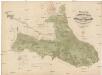
Maps of gmina Bogatynia

Vilímkovy místopisné mapy zemí Koruny české
1 : 100000 Frýdlant (Česko : oblast) Srp, Jan Jos. R. Vilímek
Podrobná mapa Království českého
1 : 100000 Frýdlant (Česko : oblast) Srp, Jan Jos. R. Vilímek
Mapy plánování ČSR

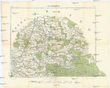
Karte der Bezirkshauptmannschaft Friedland
1 : 100000 Frýdlant-oblast (Česko) Erben, Josef Karl Janský
Bezirk Friedland

Karte des Bezirkes Friedland

Liberec
1 : 75000 Liberec-oblast (Česko) Vojenský zeměpisný ústav
Liberec
1 : 75000 Liberec (Česko : oblast) Vojenský zeměpisný ústav
Liberec
1 : 75000 Liberec-oblast (Česko) Vojenský zeměpisný ústav
Liberec
1 : 75000 Frýdlant (Česko : oblast) Vojenský zeměpisný ústav
III. vojenské mapování 3654
1 : 75000
Reichenberg u. Friedland
1 : 75000 Frýdlant (Česko : oblast) Reichenauer K. u. k. Militärgeographisches Institut
Reichenberg u. Friedland
1 : 75000 Frýdlant (Česko : oblast) Reichenauer K. u. k. Militärgeographisches Institut
Reichenberg u[nd] Friedland
1 : 75000 Frýdlant (Česko : oblast) K. u. k. Militärgeographisches Institut

III. vojenské mapování 3654/2
1 : 25000
Uiberischts- und Bestandes-Karte des ersten Forstamtbezirkes der Herrschaft Friedland
1 : 29200 Frýdlant-oblast (Česko) Wunderlich, F. Verlag des böhm. Forstvereins


III. vojenské mapování 3654/2, 3554/4
1 : 25000
[Kartenblatt]
1 : 25000 Hejnice-oblast (Liberec, Česko) Reichsamt für Landesaufnahme
[Kartenblatt]
1 : 25000 Frýdlant (Česko : oblast) Reichsamt für Landesaufnahme
III. vojenské mapování 3654/2, 3554/4
1 : 25000
[Gradkartenblatt]
1 : 25000 Frýdlant-oblast (Česko) Vojenský zeměpisný ústav
III. vojenské mapování 3654/1
1 : 25000
III. vojenské mapování 3654/2
1 : 25000
III. vojenské mapování 3654/2, 3554/4
1 : 25000
[Frýdlant a okolí]
Frýdlant-oblast (Česko)