Maps of Olomouc

Katastrální mapy, regulační plány aj. města Olomouce

Schnobolin (Slawonin) - m2781-1-003 - Kaiserpflichtexemplar der Landkarten des stabilen Katasters
1 : 2880
Schnobolin (Slawonin) - m2781-1-002 - Kaiserpflichtexemplar der Landkarten des stabilen Katasters
1 : 2880
Schnobolin (Slawonin) - m2781-1-004 - Kaiserpflichtexemplar der Landkarten des stabilen Katasters
1 : 2880
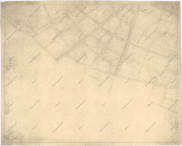
Schnobolin (Slawonin) - m2781-1-001 - Kaiserpflichtexemplar der Landkarten des stabilen Katasters
1 : 2880
Powel - m2392-1-001 - Kaiserpflichtexemplar der Landkarten des stabilen Katasters
1 : 2880
Powel - m2392-1-002 - Kaiserpflichtexemplar der Landkarten des stabilen Katasters
1 : 2880
Plan. Von der Attaque der Festung Ollmütz
Morava, řeka Bonom, Franz Xa. de
Neumittergasse (Nowa Ulice) - m2024-1-003 - Kaiserpflichtexemplar der Landkarten des stabilen Katasters
1 : 2880
Neumittergasse (Nowa Ulice) - m2024-1-002 - Kaiserpflichtexemplar der Landkarten des stabilen Katasters
1 : 2880
Neumittergasse (Nowa Ulice) - m2024-1-001 - Kaiserpflichtexemplar der Landkarten des stabilen Katasters
1 : 2880
Neumittergasse (Nowa Ulice) - m2024-1-004 - Kaiserpflichtexemplar der Landkarten des stabilen Katasters
1 : 2880
Grundris. der Stadt Olmüz
Olomouc (Česko) Storch, Kajetán
Entwurff der Stadt Olmütz
Olomouc (Česko) Salzer, Ignác Ign. Saltzer
Neretein (Herzedin) - m1961-1-001 - Kaiserpflichtexemplar der Landkarten des stabilen Katasters
1 : 2880
Neretein (Herzedin) - m1961-1-002 - Kaiserpflichtexemplar der Landkarten des stabilen Katasters
1 : 2880
Neretein (Herzedin) - m1961-1-003 - Kaiserpflichtexemplar der Landkarten des stabilen Katasters
1 : 2880
Bez Titulu: Okolí Olomouce


III. vojenské mapování 4158/4
1 : 25000
III. vojenské mapování 4158/4
1 : 25000
Gradkartenblatt
1 : 25000 Morava (Česko) Duré, Friedrich
Übersichtskarte der Gegend um Olmütz
Olomouc-oblast (Česko) Domek
Olomouc
1 : 75000 Morava (Česko) Vojenský zeměpisný ústav
Prostějov a okolí
1 : 75000 Prostějov (Česko : oblast) Vojenský zeměpisný ústav
[Tschechoslowakie, Maßstab 1:75 000]. 4158, Olomouc : sonderausgabe : nur fur den dienstgebrauch
1 : 75000
Olmutz.; Spezialkarte der osterreichisch-ungarischen Monarchie.
from Spezialkarte der osterreichisch-ungarischen Monarchie. Austro-Hungarian Monarchy. Militärgeographisches Institut.,
Plan der königl. Hauptstadt Olmütz und Umgebung
1 : 2880 Olomouc-oblast (Česko) Schnizer, E. von Ed. Hölzel
Geologische Spezialkarte der... Österreichisch-Ungarischen Monarchie... Olmütz

Plan zu den Gefechten bei Biskupitz 14. Juli Tobitschau und Roketnitz 15. Juli 1866
1 : 72000 Biskupice (Prostějov, Česko) Ditfurth, Moritz von des K. u. k. Militärgeographischen Instituts