Maps of Bubeneč

Polohopisný plán Holešovic Buben a Bubenče

Polohopisný plán Bubenče, Holešovic - Buben, pak částí Dejvic a Libně

Orientační plán hlavního města Prahy s okolím
1 : 5000
Orientační plán hlavního města Prahy s okolím

Orientační plán hlavního města Prahy s okolím
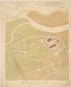
Situace Jubilejní výstavy v Praze 1908
Situace Jubilejní výstavy obvodu obchodní a živnostenské komory v Praze 1908
Entwurf eines Landes-Ausstellungsgebäudes im Baumgarten
1 : 2880 Královská obora (Praha, Česko)
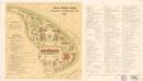
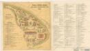
Plán Všeob. zemské jub. výstavy v Praze 1891

Jubilejní výstava obvodu Obch. a živnostenské komory v Praze roku 1908
1 : 2260 Holešovice (Praha, Česko)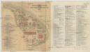
Situace Jubilejní výstavy obvodu obchodní a živnostenské komory v Praze 1908
Praha 7 (Česko) Planografie Ant. Vítek Junr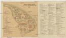
Situace Jubilejní výstavy obvodu obchodní a živnostenské komory v Praze 1908
Praha 7 (Česko) Planografie Ant. Vítek Junr
[Pražské výstaviště]
Holešovice (Praha, Česko)
Hynkův správný plán zemské jubilejní výstavy v Praze r. 1891
Holešovice (Praha, Česko) Šimáček, Josef Lutz Alois Hynek
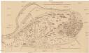
Plán zemské jubilejní výstavy v Praze dle nejnovějšího stavu rozvržení plochy až do 1. prosince 1890
Holešovice (Praha, Česko) Král z Dobré Vody, Vojtěch Lipský, Ján Vojtěch Král z Dobrévody
Definitivní plán zemské jubilejní výstavy
1 : 3400 Praha (Česko) A. Beinwart
Situační plán Všeobecné zemské jubil. výstavy v Praze 1891
Holešovice (Praha, Česko) Böttinger, Josef Líčka, Josef
Plán všeob. zemské jub. výstavy v Praze 1891
Holešovice (Praha, Česko) M & M. Wltžek
Střelecký zákop na Císařském ostrově

Centrum des Industrie-Palastes
Holešovice (Praha, Česko) Vilím, Jan
Polohopisný plán VII. části Prahy

Polohopisný plán VII. části Prahy
1 : 4000
Polohopisný plán VII. části Prahy
1 : 4000
Vorder Owenetz (Przednj Owenetz) - c0621-1-005 - Kaiserpflichtexemplar der Landkarten des stabilen Katasters
1 : 2880
Vorder Owenetz (Przednj Owenetz) - c0621-1-004 - Kaiserpflichtexemplar der Landkarten des stabilen Katasters
1 : 2880
Vorder Owenetz (Przednj Owenetz) - c0621-1-007 - Kaiserpflichtexemplar der Landkarten des stabilen Katasters
1 : 2880
Vorder Owenetz (Przednj Owenetz) - c0621-1-006 - Kaiserpflichtexemplar der Landkarten des stabilen Katasters
1 : 2880
Vorder Owenetz (Przednj Owenetz) - c0621-1-002 - Kaiserpflichtexemplar der Landkarten des stabilen Katasters
1 : 2880
Vorder Owenetz (Przednj Owenetz) - c0621-1-001 - Kaiserpflichtexemplar der Landkarten des stabilen Katasters
1 : 2880
Vorder Owenetz (Przednj Owenetz) - c0621-1-003 - Kaiserpflichtexemplar der Landkarten des stabilen Katasters
1 : 2880