Maps of Jinonice

Orientační plán Prahy a obcí sousedních List 20a.

Geologická mapa Prokopského údolí
1 : 25000 Prokopské údolí (Praha, Česko) Kodym, Odolen
Wyobrazenj geskyně a kostela u swatého Prokopa
1 : 100 Dalejské údolí (Praha, Česko) Ebner, Karel Spatný, František
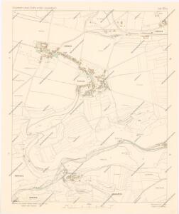
Ginonitz (Ginonic) - c2920-1-004 - Kaiserpflichtexemplar der Landkarten des stabilen Katasters
1 : 2880
Ginonitz (Ginonic) - c2920-1-002 - Kaiserpflichtexemplar der Landkarten des stabilen Katasters
1 : 2880
Ginonitz (Ginonic) - c2920-1-003 - Kaiserpflichtexemplar der Landkarten des stabilen Katasters
1 : 2880
Ginonitz (Ginonic) - c2920-1-005 - Kaiserpflichtexemplar der Landkarten des stabilen Katasters
1 : 2880
Ginonitz (Ginonic) - c2920-1-001 - Kaiserpflichtexemplar der Landkarten des stabilen Katasters
1 : 2880
Hluboczep (Hluboczepy) - c1885-1-004 - Kaiserpflichtexemplar der Landkarten des stabilen Katasters
1 : 2880
Hluboczep (Hluboczepy) - c1885-1-001 - Kaiserpflichtexemplar der Landkarten des stabilen Katasters
1 : 2880
Hluboczep (Hluboczepy) - c1885-1-003 - Kaiserpflichtexemplar der Landkarten des stabilen Katasters
1 : 2880
Hluboczep (Hluboczepy) - c1885-1-002 - Kaiserpflichtexemplar der Landkarten des stabilen Katasters
1 : 2880
Auto-Praha : automobilní plán Velké Prahy a příručka pro automobilisty
1 : 50000
Orientační plán hlavního města Prahy s okolím
1 : 5000
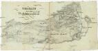
Environs de Hlubočep
1 : 6150 Hlubočepy (Praha, Česko) Barrande, Joachim
Výškopisný plán hlavního města Prahy s okolím

Orientační plán hlavního města Prahy s okolím

Orientační plán hlavního města Prahy s okolím

Orientační plán hlavního města Prahy s okolím
1 : 5000
Orientační plán hlavního města Prahy

Environs de Hlubočep
Terrain für das 2te Feldmanoeuvre
1 : 60000 Praha (Česko)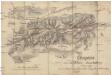
Croquis zur schriftlichen Ausarbeitung
1 : 13500 Bílá Hora (Praha, Česko)
Smíchov
1 : 5760
Smichow - c7068-1-001 - Kaiserpflichtexemplar der Landkarten des stabilen Katasters
1 : 2880
Smichow - c7068-1-005 - Kaiserpflichtexemplar der Landkarten des stabilen Katasters
1 : 2880
Smichow - c7068-1-003 - Kaiserpflichtexemplar der Landkarten des stabilen Katasters
1 : 2880
Smichow - c7068-1-002 - Kaiserpflichtexemplar der Landkarten des stabilen Katasters
1 : 2880
Smichow - c7068-1-004 - Kaiserpflichtexemplar der Landkarten des stabilen Katasters
1 : 2880