Maps of Jinonice

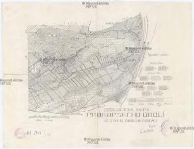
Geologická mapa Prokopského údolí
1 : 25000 Prokopské údolí (Praha, Česko) Kodym, Odolen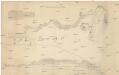
Wyobrazenj geskyně a kostela u swatého Prokopa
1 : 100 Dalejské údolí (Praha, Česko) Ebner, Karel Spatný, František
Orientační plán Prahy a obcí sousedních List 20a.

Environs de Hlubočep
1 : 6150 Hlubočepy (Praha, Česko) Barrande, Joachim
Hluboczep (Hluboczepy) - c1885-1-004 - Kaiserpflichtexemplar der Landkarten des stabilen Katasters
1 : 2880
Hluboczep (Hluboczepy) - c1885-1-001 - Kaiserpflichtexemplar der Landkarten des stabilen Katasters
1 : 2880
Hluboczep (Hluboczepy) - c1885-1-003 - Kaiserpflichtexemplar der Landkarten des stabilen Katasters
1 : 2880
Hluboczep (Hluboczepy) - c1885-1-002 - Kaiserpflichtexemplar der Landkarten des stabilen Katasters
1 : 2880
Environs de Hlubočep

Ginonitz (Ginonic) - c2920-1-004 - Kaiserpflichtexemplar der Landkarten des stabilen Katasters
1 : 2880
Ginonitz (Ginonic) - c2920-1-002 - Kaiserpflichtexemplar der Landkarten des stabilen Katasters
1 : 2880
Ginonitz (Ginonic) - c2920-1-003 - Kaiserpflichtexemplar der Landkarten des stabilen Katasters
1 : 2880
Ginonitz (Ginonic) - c2920-1-005 - Kaiserpflichtexemplar der Landkarten des stabilen Katasters
1 : 2880
Ginonitz (Ginonic) - c2920-1-001 - Kaiserpflichtexemplar der Landkarten des stabilen Katasters
1 : 2880
Orientační plán hlavního města Prahy s okolím

Orientační plán hlavního města Prahy s okolím

Orientační plán hlavního města Prahy s okolím
1 : 5000
Orientační plán hlavního města Prahy s okolím
1 : 5000
Výškopisný plán hlavního města Prahy s okolím

Orientační plán Prahy a obcí sousedních List 20.

Orientační plán hlavního města Prahy

Kriegs-Expeditions-Karte in Böhmen I. Blatt, in welchem die Haubtstadt Prag mit der Französsischen und Saechsischen Belageruug und Eroberung, so den 26. Novembre 1741 geschehen, vorgestellet wird
1 : 21000 Praha (Česko) Homann Erben
Velký příruční plán hlav. města Prahy
1 : 12000 Praha (Česko) Brož, Josef A. Storch syn
Plán král. hlav. města Prahy a obcí sousedních
1 : 12000 Praha (Česko) Brož, Josef A. Storch syn
Orientierungsplan der Hauptstadt Prag
Jiřík, Rudolf
Praha : orientační plán
1 : 15000
Praha : orientační plán : Československá spartakiáda 1975
1 : 15000
Plán význačných novostaveb pražských 1919-1934
Praha (Česko) Mánes
Plan des environs de Prague et des camps des deux armées
1 : 20700 Praha (Česko) Le Rouge, Georges-Louis Soubise, Charles de Rohan le Rouge