Maps of Stodůlky

Orientační plán Prahy a obcí sousedních List 20b.
1 : 5000
Orientační plán Prahy a obcí sousedních List 20b.

Orientační plán hlavního města Prahy s okolím
1 : 5000
Výškopisný plán hlavního města Prahy s okolím

Stodulek (Stodulka) - c7346-1-001 - Kaiserpflichtexemplar der Landkarten des stabilen Katasters
1 : 2880
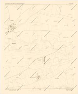
Stodulek (Stodulka) - c7346-1-002 - Kaiserpflichtexemplar der Landkarten des stabilen Katasters
1 : 2880
Stodulek (Stodulka) - c7346-1-004 - Kaiserpflichtexemplar der Landkarten des stabilen Katasters
1 : 2880
Stodulek (Stodulka) - c7346-1-003 - Kaiserpflichtexemplar der Landkarten des stabilen Katasters
1 : 2880
Orientační plán hlavního města Prahy
Terrain für das 2te Feldmanoeuvre
1 : 60000 Praha (Česko)
Ginonitz (Ginonic) - c2920-1-004 - Kaiserpflichtexemplar der Landkarten des stabilen Katasters
1 : 2880
Ginonitz (Ginonic) - c2920-1-002 - Kaiserpflichtexemplar der Landkarten des stabilen Katasters
1 : 2880
Ginonitz (Ginonic) - c2920-1-003 - Kaiserpflichtexemplar der Landkarten des stabilen Katasters
1 : 2880
Ginonitz (Ginonic) - c2920-1-005 - Kaiserpflichtexemplar der Landkarten des stabilen Katasters
1 : 2880
Ginonitz (Ginonic) - c2920-1-001 - Kaiserpflichtexemplar der Landkarten des stabilen Katasters
1 : 2880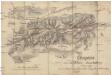
Croquis zur schriftlichen Ausarbeitung
1 : 13500 Bílá Hora (Praha, Česko)
Rzepora - c6699-1-002 - Kaiserpflichtexemplar der Landkarten des stabilen Katasters
1 : 2880
Rzepora - c6699-1-005 - Kaiserpflichtexemplar der Landkarten des stabilen Katasters
1 : 2880
Rzepora - c6699-1-003 - Kaiserpflichtexemplar der Landkarten des stabilen Katasters
1 : 2880
Rzepora - c6699-1-001 - Kaiserpflichtexemplar der Landkarten des stabilen Katasters
1 : 2880
Rzepora - c6699-1-004 - Kaiserpflichtexemplar der Landkarten des stabilen Katasters
1 : 2880
Environs de Hlubočep

Výškopisný plán hlavního města Prahy s okolím
Orientierungsplan der Hauptstadt Prag
Jiřík, Rudolf
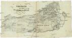
Plan des environs de Prague et des camps des deux armées
1 : 20700 Praha (Česko) Le Rouge, Georges-Louis Soubise, Charles de Rohan le Rouge
Plan des environs de Prague : et des camps des deux armées dedié a Mgr. Le Prince de Soubise
1 : 20000 Le Rouge, Georges-Louis Le Rouge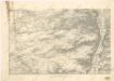
Umgebung von Prag

Výškopisný plán hlavního města Prahy s okolím
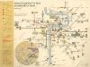
Plán sítě elektrických drah hlvního města Prahy