Maps of Vale of Glamorgan

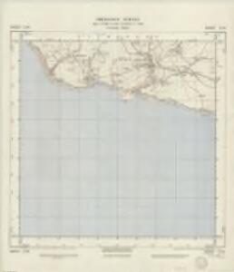
SS96 - OS 1:25,000 Provisional Series Map
1 : 25000 Topographic maps Ordnance Survey Ordnance Survey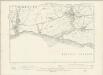
Glamorgan XLIX.NW - OS Six-Inch Map
1 : 10560 Topographic maps Ordnance Survey Ordnance Survey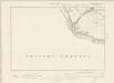
Glamorgan XLVIII.NE - OS Six-Inch Map
1 : 10560 Topographic maps Ordnance Survey Ordnance Survey
Glamorgan XLIX.1 (includes: Llantwit Major; Marcroes; St Donats) - 25 Inch Map
1 : 2500 Topographic maps Ordnance Survey Ordnance Survey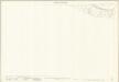
Glamorgan XLVIII.8 (includes: Marcroes; St Donats) - 25 Inch Map
1 : 2500 Topographic maps Ordnance Survey Ordnance Survey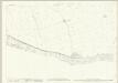
Glamorgan XLIX.7 (includes: Llantwit Major; St Athan) - 25 Inch Map
1 : 2500 Topographic maps Ordnance Survey Ordnance Survey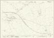
Glamorgan XLIX.3 (includes: Eglwys Brewys; Llan Faes; Llantwit Major; St Athan) - 25 Inch Map
1 : 2500 Topographic maps Ordnance Survey Ordnance Survey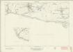
Glamorgan XLIX (inset XLVIII) - OS Six-Inch Map
1 : 10560 Topographic maps Ordnance Survey Ordnance Survey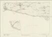
Glamorgan XLIX (inset XLVIII) - OS Six-Inch Map
1 : 10560 Topographic maps Ordnance Survey Ordnance Survey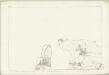
Glamorgan XLIX (inset XLVIII) - OS Six-Inch Map
1 : 10560 Topographic maps Ordnance Survey Ordnance Survey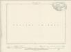
Glamorgan XLIX.SE - OS Six-Inch Map
1 : 10560 Topographic maps Ordnance Survey Ordnance Survey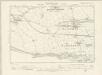
Glamorgan XLIX.NE - OS Six-Inch Map
1 : 10560 Topographic maps Ordnance Survey Ordnance Survey
Glamorgan XLV.14 (includes: Llan Faes; Llantwit Major) - 25 Inch Map
1 : 2500 Topographic maps Ordnance Survey Ordnance Survey
Glamorgan XLIV.16 (includes: Marcroes; Wick; Yr As Fawr) - 25 Inch Map
1 : 2500 Topographic maps Ordnance Survey Ordnance Survey
Glamorgan XLIV.16 (includes: Marcroes; Wick; Yr As Fawr) - 25 Inch Map
1 : 2500 Topographic maps Ordnance Survey Ordnance Survey
Glamorgan XLV.15 (includes: Eglwys Brewys; Flemingston; Llan Faes; Llantwit Major; St Mary Church) - 25 Inch Map
1 : 2500 Topographic maps Ordnance Survey Ordnance Survey
Bridgend
1 : 31680 Thomas Budgen, who worked on the majority of the Welsh plans, is probably the author of this drawing of part of Glamorgan. Following military convention, Mynydd Maendy, Mynydd Llangeinwyr and other reliefs to the north of Bridgens are represented by dense hachuring (interlining)graduating to lighter bands towards the summits. Commons, broken mountainland and upland moors are represented by open dotting. In the lower part of the sheet, field boundaries indicate agricultural land. Budgen, Thomas
Pontypridd (Hills) - OS One-Inch Revised New Series
1 : 63360 Topographic maps Ordnance Survey Ordnance Survey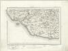
Pontypridd (Outline) - OS One-Inch Revised New Series
1 : 63360 Topographic maps Ordnance Survey Ordnance Survey
Llantrisant
This plan covers part of the southern Welsh coast. Field boundaries and woodland are indicated. Shading and soft brushwork interlining ('hachuring') denote relief. The detailed recording of the undulations of the land is a defining feature of Ordnance Survey drawings, revealing the strategic and military impetus behind the scheme. Budgen, Thomas
Glamorgan XLV.SW - OS Six-Inch Map
1 : 10560 Topographic maps Ordnance Survey Ordnance Survey
Glamorgan XLV.SW - OS Six-Inch Map
1 : 10560 Topographic maps Ordnance Survey Ordnance Survey
Glamorgan XLV.SW - OS Six-Inch Map
1 : 10560 Topographic maps Ordnance Survey Ordnance Survey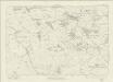
Glamorgan XLV - OS Six-Inch Map
1 : 10560 Topographic maps Ordnance Survey Ordnance Survey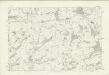
Glamorgan XLV - OS Six-Inch Map
1 : 10560 Topographic maps Ordnance Survey Ordnance Survey
Glamorgan XLV.SE - OS Six-Inch Map
1 : 10560 Topographic maps Ordnance Survey Ordnance Survey
Glamorgan XLV.SE - OS Six-Inch Map
1 : 10560 Topographic maps Ordnance Survey Ordnance Survey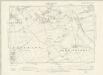
Glamorgan XLV.SE - OS Six-Inch Map
1 : 10560 Topographic maps Ordnance Survey Ordnance Survey
Cardiff - OS One-Inch Map
1 : 63360 Topographic maps Ordnance Survey Ordnance Survey