Maps of Cambrian Mountains

SN69 & Parts of SN59 - OS 1:25,000 Provisional Series Map
1 : 25000 Topographic maps Ordnance Survey Ordnance Survey
Cardiganshire I.NW - OS Six-Inch Map
1 : 10560 Topographic maps Ordnance Survey Ordnance Survey
Merionethshire XLVIII.NW - OS Six-Inch Map
1 : 10560 Topographic maps Ordnance Survey Ordnance Survey
Merionethshire XLVIII.NW - OS Six-Inch Map
1 : 10560 Topographic maps Ordnance Survey Ordnance Survey
Merionethshire XLVIII.NW - OS Six-Inch Map
1 : 10560 Topographic maps Ordnance Survey Ordnance Survey
Cardiganshire I.SW - OS Six-Inch Map
1 : 10560 Topographic maps Ordnance Survey Ordnance Survey
Merionethshire XLVIII.SW - OS Six-Inch Map
1 : 10560 Topographic maps Ordnance Survey Ordnance Survey
Cardiganshire I.SW - OS Six-Inch Map
1 : 10560 Topographic maps Ordnance Survey Ordnance Survey
Cardiganshire I.9 (includes: Tywyn) - 25 Inch Map
1 : 2500 Topographic maps Ordnance Survey Ordnance Survey
Cardiganshire III.NW - OS Six-Inch Map
1 : 10560 Topographic maps Ordnance Survey Ordnance Survey
Cardiganshire III.NW - OS Six-Inch Map
1 : 10560 Topographic maps Ordnance Survey Ordnance Survey
Cardiganshire III.NW - OS Six-Inch Map
1 : 10560 Topographic maps Ordnance Survey Ordnance Survey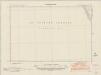
Merionethshire XLV.SE - OS Six-Inch Map
1 : 10560 Topographic maps Ordnance Survey Ordnance Survey
Merionethshire XLV.SE - OS Six-Inch Map
1 : 10560 Topographic maps Ordnance Survey Ordnance Survey
Merionethshire XLV.SE - OS Six-Inch Map
1 : 10560 Topographic maps Ordnance Survey Ordnance Survey
Aberystwyth (Outline) - OS One-Inch Revised New Series
1 : 63360 Topographic maps Ordnance Survey Ordnance Survey
Aberystwyth (Hills) - OS One-Inch Revised New Series
1 : 63360 Topographic maps Ordnance Survey Ordnance Survey
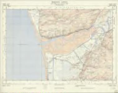
Aberdovey
1 : 31680 .A triangulation diagram appears on the reverse of this drawing. This was an essential tool enabling the draughtsman to plot topographical features. There is no hill-sketching on this drawing, suggesting an unfinished or intermediate version of the map. Yellow lines represent the borders of the printed sheet. Major lines of communication are coloured yellow, following standard military cartographic convention. Trigonometrical stations are indicated by a dot with a red triangle Hughes, Herbert, J
Merionethshire XLVI.SW - OS Six-Inch Map
1 : 10560 Topographic maps Ordnance Survey Ordnance Survey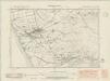
Merionethshire XLVI.SW - OS Six-Inch Map
1 : 10560 Topographic maps Ordnance Survey Ordnance Survey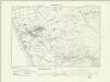
Merionethshire XLVI.SW - OS Six-Inch Map
1 : 10560 Topographic maps Ordnance Survey Ordnance Survey
Merionethshire XLVI.SW - OS Six-Inch Map
1 : 10560 Topographic maps Ordnance Survey Ordnance Survey
Merionethshire XLVI.SW - OS Six-Inch Map
1 : 10560 Topographic maps Ordnance Survey Ordnance Survey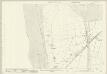
Cardiganshire I.14 (includes: Genau R Glyn; Llangynfelyn; Y Borth) - 25 Inch Map
1 : 2500 Topographic maps Ordnance Survey Ordnance Survey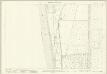
Cardiganshire III.2 (includes: Genau R Glyn; Y Borth) - 25 Inch Map
1 : 2500 Topographic maps Ordnance Survey Ordnance Survey
Cardiganshire III.6 (includes: Genau R Glyn; Y Borth) - 25 Inch Map
1 : 2500 Topographic maps Ordnance Survey Ordnance Survey
Aberystwyth - OS One-Inch Map
1 : 63360 Topographic maps Ordnance Survey Ordnance Survey
South Wales and the border in the 14th century
Rees, William Ordnance Survey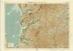
Aberystwyth, Sheet 16 - Bartholomew's "Half Inch to the Mile Maps" of England & Wales
1 : 126720 Topographic maps Bartholomew, John George John Bartholomew & Co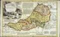
An accurate map of Cardigan Shire
1 Karte : Kupferdruck ; 33 x 52 cm Kitchin; Tinney John Tinney