Maps of West Dorset

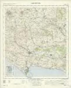
Dorchester - OS One-Inch Map
1 : 63360 Topographic maps Ordnance Survey Ordnance Survey
Dorset Shire, 2
2 Blätter : 109 x 53 cm s.n.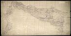
Weymouth
This drawing covers the coast of Weymouth Bay and the Isle of Portland. Lighthouses are marked on the tip of the island. Red lines denote stone walls. Sandsfoot Castle and Portland Castle are shown by blocks of red ink. These were among of a series of castles built by Henry VIII as defence against Spain and France after his divorce from the Catholic Catherine of Aragon and his breaking of ties with Rome. Chalbury Hillfort is indicated above Weymouth Bay. Archaeological sites were of interest to many of the draughtsmen and were often included even before it became obligatory to do so in 1816. The boundary with Purbeck is indicated by a red pecked line. Budgen, Charles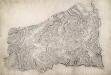
Sherborne
A red pecked line describes the border between the counties of Dorset and Somerset. Telegraph poles are marked by red dots along the lower edge of the drawing, indicating that the area covered is only a few miles from the coast. To the right of the landmass, red circles and crosses mark observation points outside the drawing's boundaries. Archaeological sites are also marked: an iron-age hillfort at Rawlsbury in the lower right is depicted by concentric rings. To the right of this is Dungeon Hill, a hillfort surrounded by a single rampart and a ditch, indicated by shading.
Dorchester
This drawing is very worn with some areas missing. The Ordnance Survey Letter Book notes that Mr Budgen was to be at Dorchester "on a new piece of work on the 29th Day of this Month", allowing us to be fairly certain of the authorship of this drawing. Maiden Castle - at 47 acres the largest iron age hillfort in Europe - is marked in the bottom left. The lines describing it follow the actual shape of the earthworks. Budgen, Charles
Shaftesbury
1 : 31680 This drawing covers the counties of Dorset, Somerset and Wiltshire, with their boundaries marked by pecked red lines. Relief is indicated by shading and interlining, giving an impression of the undulations of the land. Although the recording of archaeological sites did not become obligatory until 1816, the remains of Whitesheet Castle appear at the top centre of the drawing. Pencil lines can be seen at the edge of the drawing near Pimperne. This was an observation or measuring point for the survey.
Shaftesbury (Hills) - OS One-Inch Revised New Series
1 : 63360 Topographic maps Ordnance Survey Ordnance Survey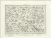
Shaftesbury (Outline) - OS One-Inch Revised New Series
1 : 63360 Topographic maps Ordnance Survey Ordnance Survey
Dorchester (Hills) - OS One-Inch Revised New Series
1 : 63360 Topographic maps Ordnance Survey Ordnance Survey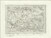
Dorchester (Outline) - OS One-Inch Revised New Series
1 : 63360 Topographic maps Ordnance Survey Ordnance Survey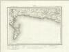
Weymouth (Outline) - OS One-Inch Revised New Series
1 : 63360 Topographic maps Ordnance Survey Ordnance Survey
Weymouth (Hills) - OS One-Inch Revised New Series
1 : 63360 Topographic maps Ordnance Survey Ordnance Survey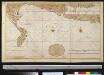
De reeden van Waijmouth en Poortland als ook de hoek van Poortland en van daer langs St. Andries Land tot de Peveral Punt int groot
England Gerard van Keulen
A Coloured Plan of the Isle of Portland and Weymouth Bay
This is a map of the coastal area of Portland Bill and Weymouth. It dates from around 1590 and may be the work of Robert Adams, a surveyor with a reputation for producing carefully drawn maps of towns and districts in England and the Low Countries. The coastline with its cliffs, beaches and tributaries is carefully recorded. At this time the security of England threatened by the Anglo-Spanish war. Raids on transatlantic shipping by English seamen such as Francis Drake and England’s support of the Protestant rebellion in the Spanish ruled Netherlands had induced the Catholic Philip II to launch the Spanish Armada in 1588. Although the Armada was defeated by the English in August of that year, England remained at war with Spain for many years to come. Further attempts to invade were made by Philip of Spain, with the dispersal of a second Armada’ in October 1596 and the assembly of the third Armada’ in the following spring. In this climate it was naturally coastal areas that were under the closest scrutiny. Topographical features are recorded pictorially with Weymouth shown in great detail with the church and sea walls discernable. Portland and Sandsfoot castles are also shown. These were built by Henry VIII during the 1539-40 threat from the combined forces of France and Spain Francis I of France and Charles V, Holy Roman Emperor and King of Spain signed a peace treaty. The castles provided essential protection of the vulnerable sea lanes of the area. Adams, Robert
Bridport
The long stretch of sand in this plan is Chesil Beach. Once linked to Spain by well- established trade routes, it is also locally famed for reported sightings of the fabled Veasta Sea Monster. Signal points are marked along coast leading down to the beach, the most notable being Abbotsbury Castle Signal Staff on Abbotsbury Common. Pencil script records the date of execution and scale of the drawing. The words "Exhibit A" are written in blue pencil at the very edge of the sheet. A reference to the village of 'Wyke' (Wyke Regis) can be seen at the far right of the drawing. Budgen, Charles
To the Right Honorable the Master, Wardens & Elder Brethren of the Trinity House, this Chart of Plymouth Sound is ... dedicated
1 : 26000 Heather, W. (William) Heather, W. (William)
ST51 - OS 1:25,000 Provisional Series Map
1 : 25000 Topographic maps Ordnance Survey Ordnance Survey
ST50 - OS 1:25,000 Provisional Series Map
1 : 25000 Topographic maps Ordnance Survey Ordnance Survey
SY59 - OS 1:25,000 Provisional Series Map
1 : 25000 Topographic maps Ordnance Survey Ordnance Survey
ST61 - OS 1:25,000 Provisional Series Map
1 : 25000 Topographic maps Ordnance Survey Ordnance Survey
SY58 - OS 1:25,000 Provisional Series Map
1 : 25000 Topographic maps Ordnance Survey Ordnance Survey
ST60 - OS 1:25,000 Provisional Series Map
1 : 25000 Topographic maps Ordnance Survey Ordnance Survey
SY69 - OS 1:25,000 Provisional Series Map
1 : 25000 Topographic maps Ordnance Survey Ordnance Survey
ST71 - OS 1:25,000 Provisional Series Map
1 : 25000 Topographic maps Ordnance Survey Ordnance Survey
SY68 - OS 1:25,000 Provisional Series Map
1 : 25000 Topographic maps Ordnance Survey Ordnance Survey
ST70 - OS 1:25,000 Provisional Series Map
1 : 25000 Topographic maps Ordnance Survey Ordnance Survey
SY79 - OS 1:25,000 Provisional Series Map
1 : 25000 Topographic maps Ordnance Survey Ordnance Survey
ST81 - OS 1:25,000 Provisional Series Map
1 : 25000 Topographic maps Ordnance Survey Ordnance Survey
SY78 - OS 1:25,000 Provisional Series Map
1 : 25000 Topographic maps Ordnance Survey Ordnance Survey