Maps of Glasgow

Lanark, Sheet X.3 (Govan) - OS 25 Inch map
1 : 2500 Topographic maps Ordnance Survey Ordnance Survey
Lanark, Sheet X.3 (Rutherglen) - OS 25 Inch map
1 : 2500 Topographic maps Ordnance Survey Ordnance Survey
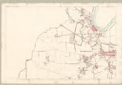
Lanarkshire, Sheet 010.03 - 25 Inch Map
1 : 2500 Topographic maps Ordnance Survey Ordnance Survey
Lanarkshire, Sheet 010.03 - 25 Inch Map
1 : 2500 Topographic maps Ordnance Survey Ordnance Survey
Lanarkshire, Sheet 010.03 - 25 Inch Map
1 : 2500 Topographic maps Ordnance Survey Ordnance Survey
Renfrew, Sheet XIII.7 (Combined) - OS 25 Inch map
1 : 2500 Topographic maps Ordnance Survey Ordnance Survey
Insurance Plan of Glasgow Vol. IV: sheet 140
1 : 480 This detailed 1898 plan of Glasgow is one of a series of fifty-five sheets in an atlas originally produced to aid insurance companies in assessing fire risks. The building footprints, their use (commercial, residential, educational, etc.), the number of floors and the height of the building, as well as construction materials (and thus risk of burning) and special fire hazards (chemicals, kilns, ovens) were documented in order to estimate premiums. Names of individual businesses, property lines, and addresses were also often recorded. Together these maps provide a rich historical shapshot of the commercial activity and urban landscape of towns and cities at the time. The British Library holds a comprehensive collection of fire insurance plans produced by the London-based firm Charles E. Goad Ltd. dating back to 1885. These plans were made for most important towns and cities of the British Isles at the scales of 1:480 (1 inch to 40 feet), as well as many foreign towns at 1:600 (1 inch to 50 feet). Chas E Goad Limited Chas E Goad Limited
Lanarkshire Sheet X.NE - OS 6 Inch map
1 : 10560 Topographic maps Ordnance Survey Ordnance Survey
Lanarkshire Sheet X.NE - OS 6 Inch map
1 : 10560 Topographic maps Ordnance Survey Ordnance Survey
Lanarkshire Sheet X.NE - OS 6 Inch map
1 : 10560 Topographic maps Ordnance Survey Ordnance Survey
Lanarkshire Sheet X.NE - OS 6 Inch map
1 : 10560 Topographic maps Ordnance Survey Ordnance Survey
Renfrewshire, Sheet XIII - OS 6 Inch map
1 : 10560 Topographic maps Ordnance Survey Ordnance Survey
Rutherglen
Great Britain. Parliament. House of Commons.
Insurance Plan of Glasgow Vol. II: Key Plan
1 : 4800 This "key plan" indicates coverage of the Goad 1889 series of fire insurance maps of Glasgow that were originally produced to aid insurance companies in assessing fire risks. The building footprints, their use (commercial, residential, educational, etc.), the number of floors and the height of the building, as well as construction materials (and thus risk of burning) and special fire hazards (chemicals, kilns, ovens) were documented in order to estimate premiums. Names of individual businesses, property lines, and addresses were also often recorded. Together these maps provide a rich historical shapshot of the commercial activity and urban landscape of towns and cities at the time. The British Library holds a comprehensive collection of fire insurance plans produced by the London-based firm Charles E. Goad Ltd. dating back to 1885. These plans were made for most important towns and cities of the British Isles at the scales of 1:480 (1 inch to 40 feet), as well as many foreign towns at 1:600 (1 inch to 50 feet). Chas E Goad Limited Chas E Goad Limited
Insurance Plan of Glasgow Vol. IV: Key Plan
1 : 4800 This "key plan" indicates coverage of the Goad 1898 series of fire insurance maps of Glasgow that were originally produced to aid insurance companies in assessing fire risks. The building footprints, their use (commercial, residential, educational, etc.), the number of floors and the height of the building, as well as construction materials (and thus risk of burning) and special fire hazards (chemicals, kilns, ovens) were documented in order to estimate premiums. Names of individual businesses, property lines, and addresses were also often recorded. Together these maps provide a rich historical shapshot of the commercial activity and urban landscape of towns and cities at the time. The British Library holds a comprehensive collection of fire insurance plans produced by the London-based firm Charles E. Goad Ltd. dating back to 1885. These plans were made for most important towns and cities of the British Isles at the scales of 1:480 (1 inch to 40 feet), as well as many foreign towns at 1:600 (1 inch to 50 feet). Chas E Goad Limited Chas E Goad Limited
Renfrewshire, Sheet 013.15 & 11 - 25 Inch Map
1 : 2500 Topographic maps Ordnance Survey Ordnance Survey
Renfrewshire, Sheet 013.11 - 25 Inch Map
1 : 2500 Topographic maps Ordnance Survey Ordnance Survey
Renfrew, Sheet XIII.11 (Combined) - OS 25 Inch map
1 : 2500 Topographic maps Ordnance Survey Ordnance Survey
Lanarkshire, Sheet X - OS 6 Inch map
1 : 10560 Topographic maps Ordnance Survey Ordnance Survey
Plan of Glasgow - Bartholomew's 'Survey Atlas of Scotland'
1 : 25000 Topographic maps John Bartholomew & Son, Ltd John Bartholomew & Son, Ltd
Map of the town of Glasgow & country seven miles around.
Richardson, Thomas, fl. 1772-1829
Glasgow - OS One-Inch map
1 : 63360 Topographic maps Ordnance Survey Ordnance Survey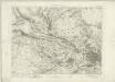
Glasgow - OS One-Inch map
1 : 63360 Topographic maps Ordnance Survey Ordnance Survey
Glasgow - OS One-Inch map
1 : 63360 Topographic maps Ordnance Survey Ordnance Survey
PRÆFECTURA | RENFROANA | Vulgo dicta | BARONIA | THE BARONIE OF | RENFROW
Timotheus Pont Auctor. [Amsterdam : Joan Blaeu]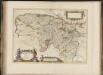
Praefectura Renfroana, vulgo, dicta Baronia. The Baronie of Renfrow / Timotheus Pont Auctor.
Pont, Timothy, 1560?-1614? Blaeu, Joan, 1596-1673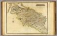
Renfrew-Shire.
1 : 73000 Thomson, John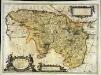
Præfectura Renfroana vulgo dicta Baronia
1 Karte : Kupferdruck ; 38 x 52 cm Blaeu; Pont Joan Blaeu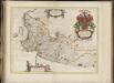
Cuninghamia / ex schedis Timotheo Pont ; Ioannis Blaeu excudebat. Cunningham.
Pont, Timothy, 1560?-1614? Blaeu, Joan, 1596-1673