Maps of Highland
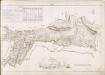
No. 8 - Plan of the Farms of Auchamore [Achmore] and Little Assynt.
Home, John, ca. 1733-1809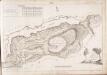
No. 10 - Plan of the Farms of Inch-na-daff [Inchnadamph] and Tubeg.
Home, John, ca. 1733-1809
Sutherland Sheet LIX - OS 6 Inch map
1 : 10560 Topographic maps Ordnance Survey Ordnance Survey
Sutherland, Sheet LIX - OS 6 Inch map
1 : 10560 Topographic maps Ordnance Survey Ordnance Survey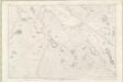
Sutherland Sheet LX - OS 6 Inch map
1 : 10560 Topographic maps Ordnance Survey Ordnance Survey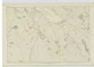
Sutherland, Sheet LX - OS 6 Inch map
1 : 10560 Topographic maps Ordnance Survey Ordnance Survey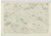
Sutherland, Sheet LXX - OS 6 Inch map
1 : 10560 Topographic maps Ordnance Survey Ordnance Survey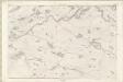
Sutherland Sheet LXX - OS 6 Inch map
1 : 10560 Topographic maps Ordnance Survey Ordnance Survey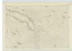
Sutherland, Sheet LXXI - OS 6 Inch map
1 : 10560 Topographic maps Ordnance Survey Ordnance Survey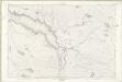
Sutherland Sheet LXXI - OS 6 Inch map
1 : 10560 Topographic maps Ordnance Survey Ordnance Survey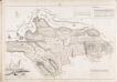
No. 7 - Plan of the Farms of Unapool and Reintraid [Rientraid].
Home, John, ca. 1733-1809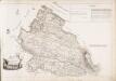
No. 6 - A Plan of the Farms of Glenlirag and Ardvare [Ardvar].
Home, John, ca. 1733-1809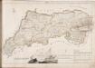
No. 12 - Plan of the Farms of Duchlash [Dubh Chlais], Polgarvier [Poll a Gharb Bhair], Drumsurdland [Druim Suardalain] and Philin [Filin].
Home, John, ca. 1733-1809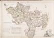
No. 5 - A Plan of the Farms of Loch Beanoch [Beannach], Nedd, Drumbeg and Culkein [Culkein Drumbeg]...
Home, John, ca. 1733-1809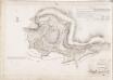
No. 9 - Plan of the Farms of Ederahalda [Eadar a Chalda] and Kirktown [Kirkton].
Home, John, ca. 1733-1809
Lochinver - OS One-Inch map
1 : 63360 Topographic maps Ordnance Survey Ordnance Survey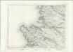
Lochinver - OS One-Inch map
1 : 63360 Topographic maps Ordnance Survey Ordnance Survey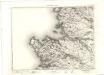
Lochinver - OS One-Inch map
1 : 63360 Topographic maps Ordnance Survey Ordnance Survey
Lochinver & Loch Assynt (15) - OS One-Inch map
1 : 63360 Topographic maps Ordnance Survey Ordnance Survey
Lochinver & Loch Assynt (15) - OS One-Inch map
1 : 63360 Topographic maps Ordnance Survey Ordnance Survey
Loch Inver and Loch Assynt - OS One-Inch Map
1 : 63360 Topographic maps Ordnance Survey Ordnance Survey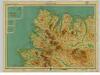
Cape Wrath, Sheet 26 - Bartholomew's "Half Inch to the Mile Maps" of Scotland
1 : 126720 Topographic maps John Bartholomew & Son, Ltd John Bartholomew & Son, Ltd
Cape Wrath & Tongue, Sheet 26 - Bartholomew's "Half Inch to the Mile Maps" of Scotland
1 : 126720 Topographic maps Bartholomew, John George John Bartholomew & Co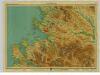
Loch Broom, Sheet 24 - Bartholomew's "Half Inch to the Mile Maps" of Scotland
1 : 126720 Topographic maps John Bartholomew & Son, Ltd John Bartholomew & Son, Ltd
Gair Loch & Loch Inver, Sheet 24 - Bartholomew's "Half Inch to the Mile Maps" of Scotland
1 : 126720 Topographic maps Bartholomew, John George John Bartholomew & Co
The North Minch
Great Britain. Hydrographic Office
Sutherlandshire.
Forbes, William, fl. 1790-1826
Sketch of the the county of Sutherland showing the boundaries & divisions of the earldom of Sutherland.
Anon.
Map of the county of Sutherland made on the basis of the trigonometrical survey of Scotland in the years 1831, 1832.
Burnett, Gregory, fl. 1820?-1844 Scott, William, fl. ca. 1830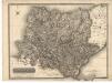
![No. 8 - Plan of the Farms of Auchamore [Achmore] and Little Assynt.](https://images-2.georeferencer.com/images/iiif/638533744832/full/,300/0/native.jpg)

