Maps of Highland
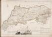
No. 12 - Plan of the Farms of Duchlash [Dubh Chlais], Polgarvier [Poll a Gharb Bhair], Drumsurdland [Druim Suardalain] and Philin [Filin].
Home, John, ca. 1733-1809
Sutherland, Sheet LXX - OS 6 Inch map
1 : 10560 Topographic maps Ordnance Survey Ordnance Survey
Sutherland Sheet LXX - OS 6 Inch map
1 : 10560 Topographic maps Ordnance Survey Ordnance Survey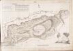
No. 10 - Plan of the Farms of Inch-na-daff [Inchnadamph] and Tubeg.
Home, John, ca. 1733-1809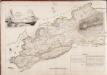
No. 13 - Plan of the Farms of Knockneach [Cnoc nan Each], Culach [Culag] and Inverchirkag [Inverkirkaig].
Home, John, ca. 1733-1809
Ross and Cromarty Sheet I - OS 6 Inch map
1 : 10560 Topographic maps Ordnance Survey Ordnance Survey
Ross-shire & Cromartyshire (Mainland), Sheet I - OS 6 Inch map
1 : 10560 Topographic maps Ordnance Survey Ordnance Survey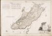
No. 4 - A Plan of the Farms of Brackloch, Inver, Torbreck, Baddedaroch [Baddidarach] and Batachrianan [Bad a' Ghrianan]
Home, John, ca. 1733-1809
Lochinver - OS One-Inch map
1 : 63360 Topographic maps Ordnance Survey Ordnance Survey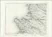
Lochinver - OS One-Inch map
1 : 63360 Topographic maps Ordnance Survey Ordnance Survey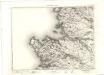
Lochinver - OS One-Inch map
1 : 63360 Topographic maps Ordnance Survey Ordnance Survey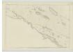
Sutherland, Sheet LXXXI - OS 6 Inch map
1 : 10560 Topographic maps Ordnance Survey Ordnance Survey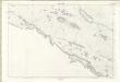
Sutherland Sheet LXXXI - OS 6 Inch map
1 : 10560 Topographic maps Ordnance Survey Ordnance Survey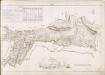
No. 8 - Plan of the Farms of Auchamore [Achmore] and Little Assynt.
Home, John, ca. 1733-1809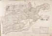
No. 14 - Plan of the Farm of Ledbeg.
Home, John, ca. 1733-1809
Sutherland Sheet LXIX - OS 6 Inch map
1 : 10560 Topographic maps Ordnance Survey Ordnance Survey
Sutherland, Sheet LXIX - OS 6 Inch map
1 : 10560 Topographic maps Ordnance Survey Ordnance Survey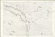
Sutherland Sheet LXXI - OS 6 Inch map
1 : 10560 Topographic maps Ordnance Survey Ordnance Survey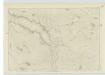
Sutherland, Sheet LXXI - OS 6 Inch map
1 : 10560 Topographic maps Ordnance Survey Ordnance Survey
Loch Inver and Loch Roe
Great Britain. Hydrographic Office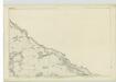
Ross-shire & Cromartyshire (Mainland), Sheet II - OS 6 Inch map
1 : 10560 Topographic maps Ordnance Survey Ordnance Survey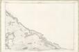
Ross and Cromarty Sheet II - OS 6 Inch map
1 : 10560 Topographic maps Ordnance Survey Ordnance Survey
Lochinver & Loch Assynt (15) - OS One-Inch map
1 : 63360 Topographic maps Ordnance Survey Ordnance Survey
Lochinver & Loch Assynt (15) - OS One-Inch map
1 : 63360 Topographic maps Ordnance Survey Ordnance Survey
Loch Inver and Loch Assynt - OS One-Inch Map
1 : 63360 Topographic maps Ordnance Survey Ordnance Survey
Ullapool, Lochinver - Bartholomew's 'Survey Atlas of Scotland'
1 : 126720 Topographic maps John Bartholomew & Son, Ltd John Bartholomew & Son, Ltd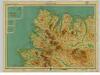
Cape Wrath, Sheet 26 - Bartholomew's "Half Inch to the Mile Maps" of Scotland
1 : 126720 Topographic maps John Bartholomew & Son, Ltd John Bartholomew & Son, Ltd
Cape Wrath & Tongue, Sheet 26 - Bartholomew's "Half Inch to the Mile Maps" of Scotland
1 : 126720 Topographic maps Bartholomew, John George John Bartholomew & Co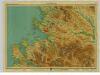
Loch Broom, Sheet 24 - Bartholomew's "Half Inch to the Mile Maps" of Scotland
1 : 126720 Topographic maps John Bartholomew & Son, Ltd John Bartholomew & Son, Ltd
![No. 12 - Plan of the Farms of Duchlash [Dubh Chlais], Polgarvier [Poll a Gharb Bhair], Drumsurdland [Druim Suardalain] and Philin [Filin].](https://images-2.georeferencer.com/images/iiif/755540659278/full/,300/0/native.jpg)

