Maps of Fife

Map of the counties of Fife and Kinross.
Greenwood, Christopher, 1786-1855 Fowler, William, fl. 1818-1863 Sharp, T.
Map of the counties of Fife and Kinross.
Greenwood, Christopher, 1786-1855 Fowler, William, fl. 1818-1863 Sharp, T.
Map of the counties of Fife and Kinross.
Greenwood, Christopher, 1786-1855 Fowler, William, fl. 1818-1863 Sharp, T.
Counties of Fife and Kinross with the Rivers Forth and Tay
Ainslie, John, 1745-1828
Map of the counties of Fife and Kinross.
Greenwood, Christopher, 1786-1855 Fowler, William, fl. 1818-1863 Sharp, T.
Counties of Fife and Kinross with the Rivers Forth and Tay
Ainslie, John, 1745-1828
Counties of Fife and Kinross with the Rivers Forth and Tay
Ainslie, John, 1745-1828
Counties of Fife and Kinross with the Rivers Forth and Tay
Ainslie, John, 1745-1828
Counties of Fife and Kinross with the Rivers Forth and Tay
Ainslie, John, 1745-1828
Counties of Fife and Kinross with the Rivers Forth and Tay
Ainslie, John, 1745-1828
Fife with Kinross Shire.
Thomson, John, 1777- ca. 1840 Johnson, William, fl. 1806-1840
Fife with Kinross Shire.
Thomson, John, 1777- ca. 1840 Johnson, William, fl. 1806-1840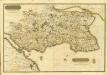
Composite: Fife, Kinross.
1 : 75000 Martin, Alexander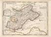
The Shires of Fife and Kinros / by H. Moll.
Moll, Herman, d. 1732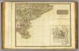
Perthshire SE.
1 : 131000 Storie, James
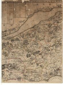
FIFÆ | VICECOMITATVS, | The Sherifdome of FYFE.
[Amsterdam : Joan Blaeu]
Fifæ vicecomitatvs
1 Karte : Kupferdruck ; 40 x 51 cm Blaeu Joan Blaeu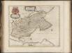
Fifae Vicecomitatus, The Sherifdome of Fyfe.
Gordon, James, 1615?-1686 Blaeu, Joan, 1596-1673
FIFÆ PARS | ORIENTALIS, | THE EAST PART OF FIFE.
[Amsterdam : Joan Blaeu]
Fifæ pars orientalis
1 Karte : Kupferdruck ; 40 x 51 cm Blaeu Joan Blaeu
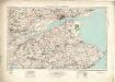
Fife, Kinross - Bartholomew's 'Survey Atlas of Scotland'
1 : 126720 Topographic maps John Bartholomew & Son, Ltd John Bartholomew & Son, Ltd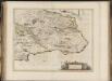
Fifae Pars Orientalis, [vulgo], The East Part of Fife.
Blaeu, Joan, 1596-1673
St Andrews and Kirkcaldy - OS One-Inch Map
1 : 63360 Topographic maps Ordnance Survey Ordnance Survey
Edinburgh Firth.
Collins, Greenvile, fl. 1669-1698
The Hydrographicall mappe of Forth from the entry to ye Queens-ferry / authore Jo. Adair.
Adair, John, ca. 1650-1722
Carte du Golphe d'Edinburgh.
Bellin, J. N.
The East Part of Fife / surveyed & designed be [i.e. by] John Adair.
Adair, John, ca. 1650-1722
Fife E.
1 : 75000 Martin, Alexander
FIFÆ PARS | OCCIDENTALIS, | THE WEST PART OF FIFE.
[Amsterdam : Joan Blaeu]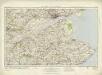
Dundee & St Andrews (64) - OS One-Inch map
1 : 63360 Topographic maps Ordnance Survey Ordnance Survey