Maps of Argyll and Bute
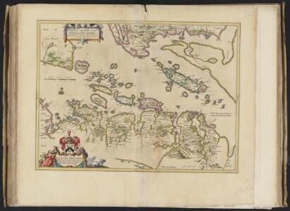
Lorna cum insulis vicinis et provinciis eidem conterminis. Lorn wt the Yles and provinces bordering there-upon / Auct. Timoth. Pont.
Pont, Timothy, 1560?-1614? Blaeu, Joan, 1596-1673
Lorna cum insulis vicinis et provinciis eidem conterminis
1 Karte : Kupferdruck ; 38 x 51 cm Blaeu; Pont Joan Blaeu
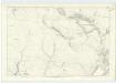
Argyll, Sheet 11 - Bartholomew's "Half Inch to the Mile Maps" of Scotland
1 : 126720 Topographic maps John Bartholomew & Son, Ltd John Bartholomew & Son, Ltd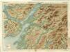
Oban & Loch Awe, Sheet 11 - Bartholomew's "Half Inch to the Mile Maps" of Scotland
1 : 126720 Topographic maps Bartholomew, John George John Bartholomew & Co
LORNA cum insulis vicinis | et provinciis eidem conterminis. | LORN Wt the Yles and provinces | bordering there-vpon.
Auct. Timoth. Pont. [Amsterdam : Joan Blaeu]
Inveraray - Bartholomew's 'Survey Atlas of Scotland'
1 : 126720 Topographic maps John Bartholomew & Son, Ltd John Bartholomew & Son, Ltd
Loch Awe - OS One-Inch Map
1 : 63360 Topographic maps Ordnance Survey Ordnance Survey
North Jura & Firth of Lorne (60) - OS One-Inch map
1 : 63360 Topographic maps Ordnance Survey Ordnance Survey
North Jura & Firth of Lorne (60) - OS One-Inch map
1 : 63360 Topographic maps Ordnance Survey Ordnance Survey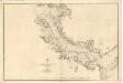
Sound of Mull
Great Britain. Hydrographic Office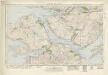
Sound of Mull (53) - OS One-Inch map
1 : 63360 Topographic maps Ordnance Survey Ordnance Survey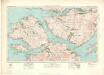
Sound of Mull (53) - OS One-Inch map
1 : 63360 Topographic maps Ordnance Survey Ordnance Survey
Loch Linnhe - OS One-Inch Map
1 : 63360 Topographic maps Ordnance Survey Ordnance Survey
Kilmartin - OS One-Inch map
1 : 63360 Topographic maps Ordnance Survey Ordnance Survey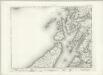
Kilmartin - OS One-Inch map
1 : 63360 Topographic maps Ordnance Survey Ordnance Survey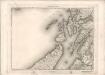
Kilmartin - OS One-Inch map
1 : 63360 Topographic maps Ordnance Survey Ordnance Survey
Mull - OS One-Inch map
1 : 63360 Topographic maps Ordnance Survey Ordnance Survey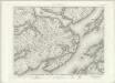
Mull - OS One-Inch map
1 : 63360 Topographic maps Ordnance Survey Ordnance Survey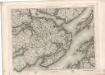
Mull - OS One-Inch map
1 : 63360 Topographic maps Ordnance Survey Ordnance Survey
Loch Crinan to Cuan Sound
Great Britain. Hydrographic Office
Loch Linnhe, Southern Part
Great Britain. Hydrographic Office
Inner Channel: Sound of Seil to the Sound of Mull
Great Britain. Hydrographic Office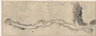
Loch Awe
Great Britain. Hydrographic Office
Tobermory - OS One-Inch map
1 : 63360 Topographic maps Ordnance Survey Ordnance Survey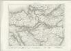
Tobermory - OS One-Inch map
1 : 63360 Topographic maps Ordnance Survey Ordnance Survey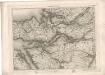
Tobermory - OS One-Inch map
1 : 63360 Topographic maps Ordnance Survey Ordnance Survey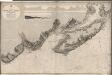
Lochs Buy and Spelve
Great Britain. Hydrographic Office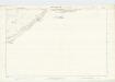
Argyllshire, Sheet CXIX - OS 6 Inch map
1 : 10560 Topographic maps Ordnance Survey Ordnance Survey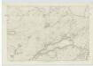
Argyllshire, Sheet CXXIII - OS 6 Inch map
1 : 10560 Topographic maps Ordnance Survey Ordnance Survey