Maps of Northumberland

Northumberland (New Series) VI.13 (includes: Cornhill On Tweed) - 25 Inch Map
1 : 2500 Topographic maps Ordnance Survey Ordnance Survey
Northumberland nVI.SW - OS Six-Inch Map
1 : 10560 Topographic maps Ordnance Survey Ordnance Survey
Northumberland (Old Series) IX.8 (includes: Cornhill On Tweed) - 25 Inch Map
1 : 2500 Topographic maps Ordnance Survey Ordnance Survey
Northumberland (Old Series) IX.12 (includes: Cornhill On Tweed; Ford) - 25 Inch Map
1 : 2500 Topographic maps Ordnance Survey Ordnance Survey
Berwickshire, Sheet XXIX - OS 6 Inch map
1 : 10560 Topographic maps Ordnance Survey Ordnance Survey
Northumberland IX.NE - OS Six-Inch Map
1 : 10560 Topographic maps Ordnance Survey Ordnance Survey
Northumberland IX.SE - OS Six-Inch Map
1 : 10560 Topographic maps Ordnance Survey Ordnance Survey
Berwickshire Sheet XXIII.NE & XXIV.NW - OS 6 Inch map
1 : 10560 Topographic maps Ordnance Survey Ordnance Survey
Berwick, Sheet XXIX.10 (with inset XXIX.14) (Coldstream) - OS 25 Inch map
1 : 2500 Topographic maps Ordnance Survey Ordnance Survey
Berwickshire, Sheet 029.10 - 25 Inch Map
1 : 2500 Topographic maps Ordnance Survey Ordnance Survey
Berwickshire, Sheet 029.10 - 25 Inch Map
1 : 2500 Topographic maps Ordnance Survey Ordnance Survey
Ford (Hills) - OS One-Inch Revised New Series
1 : 63360 Topographic maps Ordnance Survey Ordnance Survey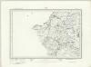
Ford (Outline) - OS One-Inch Revised New Series
1 : 63360 Topographic maps Ordnance Survey Ordnance Survey
Berwick Upon Tweed - OS One-Inch map
1 : 63360 Topographic maps Ordnance Survey Ordnance Survey
Berwick Upon Tweed - OS One-Inch map
1 : 63360 Topographic maps Ordnance Survey Ordnance Survey
Berwick Upon Tweed - OS One-Inch map
1 : 63360 Topographic maps Ordnance Survey Ordnance Survey
Kelso & The Cheviot (81) - OS One-Inch map
1 : 63360 Topographic maps Ordnance Survey Ordnance Survey
Kelso & The Cheviot (81) - OS One-Inch map
1 : 63360 Topographic maps Ordnance Survey Ordnance Survey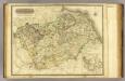
Berwick-shire.
1 : 90000 Thomson, John
Map of the County of Berwick.
Armstrong, Andrew, 1700-1794 Armstrong, Mostyn, fl. 1769-1791
Map of the County of Berwick.
Armstrong, Andrew, 1700-1794 Armstrong, Mostyn, fl. 1769-1791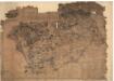
Berwickshire.
Blackadder, John, fl. 1793-1830
Map of the County of Berwick.
Armstrong, Andrew, 1700-1794 Armstrong, Mostyn, fl. 1769-1791
The County of Berwick.
Greenwood, Christopher, 1786-1855 Fowler, William, fl. 1818-1863 Sharp, T.
The County of Berwick.
Greenwood, Christopher, 1786-1855 Fowler, William, fl. 1818-1863 Sharp, T.
Map of the County of Berwick.
Armstrong, Andrew, 1700-1794 Armstrong, Mostyn, fl. 1769-1791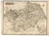
Berwick-Shire.
Thomson, John, 1777- ca. 1840 Johnson, William, fl. 1806-1840
Mercia vulgo vicecomitatvs Bervicensis
1 Karte : Kupferdruck ; 36 x 48 cm Pont; Blaeu Joan Blaeu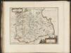
Mercia, vulgo vicecomitatus, Bervicensis / auct. Timothei Pont. Merce or Shirrefdome of Berwick.
Pont, Timothy, 1560?-1614? Blaeu, Joan 1596-1673


