Maps of Staffordshire Moorlands
Staffordshire I.14 (includes: Quarnford; Wildboarclough; Wincle) - 25 Inch Map
1 : 2500 Topographic maps Ordnance Survey Ordnance Survey
Staffordshire I.14 (includes: Quarnford; Wildboarclough; Wincle) - 25 Inch Map
1 : 2500 Topographic maps Ordnance Survey Ordnance Survey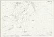
Cheshire XLIV.7 (includes: Wildboarclough) - 25 Inch Map
1 : 2500 Topographic maps Ordnance Survey Ordnance Survey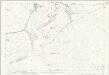
Cheshire XLIV.7 (includes: Wildboarclough) - 25 Inch Map
1 : 2500 Topographic maps Ordnance Survey Ordnance Survey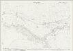
Cheshire XLIV.11 (includes: Heaton; Leekfrith; Quarnford; Wildboarclough; Wincle) - 25 Inch Map
1 : 2500 Topographic maps Ordnance Survey Ordnance Survey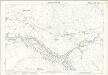
Cheshire XLIV.11 (includes: Heaton; Leekfrith; Quarnford; Wildboarclough; Wincle) - 25 Inch Map
1 : 2500 Topographic maps Ordnance Survey Ordnance Survey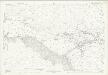
Cheshire XLIV.11 (includes: Heaton; Leekfrith; Quarnford; Wildboarclough; Wincle) - 25 Inch Map
1 : 2500 Topographic maps Ordnance Survey Ordnance Survey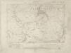
Staffordshire I.SW - OS Six-Inch Map
1 : 10560 Topographic maps Ordnance Survey Ordnance Survey
Staffordshire I.SW - OS Six-Inch Map
1 : 10560 Topographic maps Ordnance Survey Ordnance Survey
Staffordshire I.SW - OS Six-Inch Map
1 : 10560 Topographic maps Ordnance Survey Ordnance Survey
Cheshire XLIV - OS Six-Inch Map
1 : 10560 Topographic maps Ordnance Survey Ordnance Survey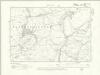
Cheshire XLIV.NE - OS Six-Inch Map
1 : 10560 Topographic maps Ordnance Survey Ordnance Survey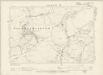
Cheshire XLIV.NE - OS Six-Inch Map
1 : 10560 Topographic maps Ordnance Survey Ordnance Survey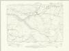
Cheshire XLIV.SE - OS Six-Inch Map
1 : 10560 Topographic maps Ordnance Survey Ordnance Survey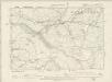
Cheshire XLIV.SE - OS Six-Inch Map
1 : 10560 Topographic maps Ordnance Survey Ordnance Survey
Cheshire XLIV.8 (includes: Hartington Upper Quarter; Quarnford; Wildboarclough) - 25 Inch Map
1 : 2500 Topographic maps Ordnance Survey Ordnance Survey
Cheshire XLIV.8 (includes: Hartington Upper Quarter; Quarnford; Wildboarclough) - 25 Inch Map
1 : 2500 Topographic maps Ordnance Survey Ordnance Survey
Cheshire XLIV.12 (includes: Quarnford; Wildboarclough) - 25 Inch Map
1 : 2500 Topographic maps Ordnance Survey Ordnance Survey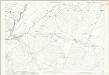
Cheshire XLIV.12 (includes: Quarnford; Wildboarclough) - 25 Inch Map
1 : 2500 Topographic maps Ordnance Survey Ordnance Survey
Longnor
1 : 31680 The right-hand portion of this drawing has pencil annotations that are now too faint to read. A triangulation diagram appears on the reverse. This enabled the draughtsman to plot topographical features of the landscape. There is no hill sketching, suggesting that this is an intermediate version of the plan. Major lines of communication are coloured yellow, following military cartographic convention. Stevens, Henry
Macclesfield
1 : 31680 .This drawing covers the counties of Cheshire and Staffordshire, the boundary being indicated by a red pecked line. There is no hill sketching on this drawing, suggesting that it is an intermediate version rather than the finished plan. Yellow lines represent the borders of the printed sheet. Major lines of communication are coloured yellow, following standard military cartographic convention. The Macclesfield Canal stretches across the drawing from top to bottom, marked by a royal blue line and,broken by locks. Approved by an Act of Parliament in April 1826, the canal route was surveyed by Thomas Telford and constructed by William Crosley. It was built to serve the mills, mines and quarries of the Macclesfield and Congleton areas, forming a link from Manchester to the Potteries and Midlands. The canal was opened in November 1831. Stevens, Henry
Ordnance Survey hill sketches
Ordnance Survey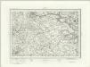
Buxton (Outline) - OS One-Inch Revised New Series
1 : 63360 Topographic maps Ordnance Survey Ordnance Survey
Buxton (Hills) - OS One-Inch Revised New Series
1 : 63360 Topographic maps Ordnance Survey Ordnance Survey
Stoke on Trent - OS One-Inch Map
1 : 63360 Topographic maps Ordnance Survey Ordnance Survey
Buxton and Matlock - OS One-Inch Map
1 : 63360 Topographic maps Ordnance Survey Ordnance Survey
An accurate map of the county of Derby
1 Karte : Kupferdruck ; 68 x 52 cm Bowen; Tinney; Bowles; Sayer; Bowles; Bowles sold by R. Sayer at the Golden Buck and I. Tinney at the Golden Lion in Fleet street T. Bowles in St. Pauls Church yard and I. Bowles and son in Cornhill
Darbiensis comitatvs vernacule Darbie Shire
1 Karte : Kupferdruck ; 37 x 48 cm Blaeu Joan Blaeu
An improved map of the county of Stafford
1 Karte : Kupferdruck ; 67 x 51 cm Bowen; Hinton sold by I. Hinton at the Kings Arms in St. Pauls Church Yard