Maps of South Kesteven

Lincolnshire CXXXIX.11 (includes: Castle Bytham; Little Bytham) - 25 Inch Map
1 : 2500 Topographic maps Ordnance Survey Ordnance Survey
Lincolnshire CXXXIX.11 (includes: Castle Bytham; Little Bytham) - 25 Inch Map
1 : 2500 Topographic maps Ordnance Survey Ordnance Survey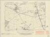
Lincolnshire CXXXIX.SE - OS Six-Inch Map
1 : 10560 Topographic maps Ordnance Survey Ordnance Survey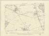
Lincolnshire CXXXIX.SE - OS Six-Inch Map
1 : 10560 Topographic maps Ordnance Survey Ordnance Survey
Lincolnshire CXXXIX.SE - OS Six-Inch Map
1 : 10560 Topographic maps Ordnance Survey Ordnance Survey
Rutland III.SE - OS Six-Inch Map
1 : 10560 Topographic maps Ordnance Survey Ordnance Survey
SK91 - OS 1:25,000 Provisional Series Map
1 : 25000 Topographic maps Ordnance Survey Ordnance Survey
Bourn (Hills) - OS One-Inch Revised New Series
1 : 63360 Topographic maps Ordnance Survey Ordnance Survey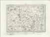
Bourn (Outline) - OS One-Inch Revised New Series
1 : 63360 Topographic maps Ordnance Survey Ordnance Survey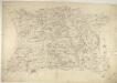
Corby
1 : 31680 This drawing covers parts of Northamptonshire and its neighbouring counties. Their boundaries are indicated by a red pecked line. The road running down the middle of the sheet is Ermine Street, the ancient Roman road from Chichester to York, passing through Lincolnshire. Right of centre is Grimsthorpe Park, with its avenues, trees, reservoir and lodge painstakingly illustrated. Boyce
Rvtlandia comitatvs
1 Karte : Kupferdruck ; 37 x 48 cm Blaeu Joan Blaeu
RVTLANDIA | COMITATVS. | RVTLAND SHIRE.
[Amsterdam : Joan Blaeu]
Rutlandia Comitatus. Rutland Shire. [Karte], in: Theatrum orbis terrarum, sive, Atlas novus, Bd. 4, S. 332.
1 Karte aus Atlas Blaeu, Joan Blaeu, Willem Janszoon
Rutlandia Comitatus. Rutland Shire. [Karte], in: Theatrum orbis terrarum, sive, Atlas novus, Bd. 4, S. 332.
1 Karte aus Atlas Blaeu, Joan Blaeu, Willem Janszoon
Rutlandia Comitatus. Rutland Shire. [Karte], in: Le théâtre du monde, ou, Nouvel atlas contenant les chartes et descriptions de tous les païs de la terre, Bd. 4, S. 290.
1 Karte aus Atlas Blaeu, Willem Janszoon und Blaeu, Joan Blaeu, Willem Janszoon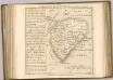

Spalding - OS One-Inch Map
1 : 63360 Topographic maps Ordnance Survey Ordnance Survey
Leicestrensis Comitatus cum Rutlandiae vulgo Leicester & Rutland Shire
1 : 160000 Amstelodami : ex. Joannes Janssonius
Lincoln Fens, Sheet 14 - Bartholomew's "Half Inch to the Mile Maps" of England & Wales
1 : 126720 Topographic maps Bartholomew, John George John Bartholomew & Co
An accurate map of the counties of Leicester and Rutland
1 Karte : Kupferdruck ; 52 x 68 cm Bowen; Tinney; Bowles; Sayer; Bowles; Bowles printed for I. Tinney at the Golden Lion and R. Sayer at the Golden Buck in Fleet street T. Bowles in St. Paul's Church yard and I. Bowles and son at the Black Horse in Cornhill
Leicestrensis comitatvs cum Rvtlandiæ vulgo Leicester [and] Rutland Shire
1 Karte : Kupferdruck ; 42 x 52 cm Valck; Schenk penes Gerardum Valk et Petrum Schenk
LEICESTRENSIS | COMITATVS. | LEICESTER SHIRE.
[Amsterdam : Joan Blaeu]
Leicestrensis Comitatus cum Rutlandiae. Vulgo Leicester & Rutland Shire. [Karte], in: Novus atlas absolutissimus, Bd. 7, S. 316.
1 Karte aus Atlas Janssonius Offizin
Leicestrensis Comitatus. Leicester Shire. [Karte], in: Le théâtre du monde, ou, Nouvel atlas contenant les chartes et descriptions de tous les païs de la terre, Bd. 4, S. 287.
1 Karte aus Atlas Blaeu, Willem Janszoon und Blaeu, Joan Blaeu, Willem Janszoon
Leicestrensis Comitatus. Leicester Shire. [Karte], in: Theatrum orbis terrarum, sive, Atlas novus, Bd. 4, S. 327.
1 Karte aus Atlas Blaeu, Joan Blaeu, Willem Janszoon
Leicestrensis Comitatus. Leicester Shire. [Karte], in: Theatrum orbis terrarum, sive, Atlas novus, Bd. 4, S. 327.
1 Karte aus Atlas Blaeu, Joan Blaeu, Willem Janszoon
Comitatis Cantabrigiensis, vernacule Cambridge Shire
1 : 210000 Amstelodami : apud Joannem Janssonium
Cantabrigiensis Comitatus; Cambridge Shire. [Karte], in: Theatrum orbis terrarum, sive, Atlas novus, Bd. 4, S. 306.
1 Karte aus Atlas Blaeu, Joan Blaeu, Willem Janszoon
Cantabrigiensis Comitatus; Cambridge Shire. [Karte], in: Le théâtre du monde, ou, Nouvel atlas contenant les chartes et descriptions de tous les païs de la terre, Bd. 4, S. 270.
1 Karte aus Atlas Blaeu, Willem Janszoon und Blaeu, Joan Blaeu, Willem Janszoon


