Maps of Norfolk

Norfolk VIII.NE - OS Six-Inch Map
1 : 10560 Topographic maps Ordnance Survey Ordnance Survey
Norfolk VIII.NE - OS Six-Inch Map
1 : 10560 Topographic maps Ordnance Survey Ordnance Survey
Norfolk VIII.NE - OS Six-Inch Map
1 : 10560 Topographic maps Ordnance Survey Ordnance Survey
Norfolk VIII.NE - OS Six-Inch Map
1 : 10560 Topographic maps Ordnance Survey Ordnance Survey
Norfolk VIII.NE - OS Six-Inch Map
1 : 10560 Topographic maps Ordnance Survey Ordnance Survey
Norfolk VIII.8 (includes: Stiffkey; Warham) - 25 Inch Map
1 : 2500 Topographic maps Ordnance Survey Ordnance Survey
Norfolk VIII.8 (includes: Stiffkey; Warham) - 25 Inch Map
1 : 2500 Topographic maps Ordnance Survey Ordnance Survey
Norfolk VIII.8 (includes: Stiffkey; Warham) - 25 Inch Map
1 : 2500 Topographic maps Ordnance Survey Ordnance Survey
Norfolk VIII.8 (includes: Stiffkey; Warham) - 25 Inch Map
1 : 2500 Topographic maps Ordnance Survey Ordnance Survey
Norfolk VIII.4 (includes: Stiffkey; Warham) - 25 Inch Map
1 : 2500 Topographic maps Ordnance Survey Ordnance Survey
Norfolk VIII.4 (includes: Stiffkey; Warham) - 25 Inch Map
1 : 2500 Topographic maps Ordnance Survey Ordnance Survey
Norfolk VIII.4 (includes: Stiffkey; Warham) - 25 Inch Map
1 : 2500 Topographic maps Ordnance Survey Ordnance Survey
Norfolk VIII.4 (includes: Stiffkey; Warham) - 25 Inch Map
1 : 2500 Topographic maps Ordnance Survey Ordnance Survey
Norfolk VIII.7 (includes: Warham; Wells Next The Sea; Wighton) - 25 Inch Map
1 : 2500 Topographic maps Ordnance Survey Ordnance Survey
Norfolk VIII.7 (includes: Warham; Wells Next The Sea; Wighton) - 25 Inch Map
1 : 2500 Topographic maps Ordnance Survey Ordnance Survey
Norfolk VIII.7 (includes: Warham; Wells Next The Sea; Wighton) - 25 Inch Map
1 : 2500 Topographic maps Ordnance Survey Ordnance Survey
Norfolk VIII.7 (includes: Warham; Wells Next The Sea; Wighton) - 25 Inch Map
1 : 2500 Topographic maps Ordnance Survey Ordnance Survey
Norfolk VIII.3 (includes: Warham; Wells Next The Sea) - 25 Inch Map
1 : 2500 Topographic maps Ordnance Survey Ordnance Survey
Norfolk VIII.3 (includes: Warham; Wells Next The Sea) - 25 Inch Map
1 : 2500 Topographic maps Ordnance Survey Ordnance Survey
Norfolk VIII.3 (includes: Warham; Wells Next The Sea) - 25 Inch Map
1 : 2500 Topographic maps Ordnance Survey Ordnance Survey
Norfolk VIII.3 (includes: Warham; Wells Next The Sea) - 25 Inch Map
1 : 2500 Topographic maps Ordnance Survey Ordnance Survey
TF94 - OS 1:25,000 Provisional Series Map
1 : 25000 Topographic maps Ordnance Survey Ordnance Survey
Wells next the Sea (Hills) - OS One-Inch Revised New Series
1 : 63360 Topographic maps Ordnance Survey Ordnance Survey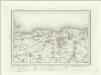
Wells next the Sea (Outline) - OS One-Inch Revised New Series
1 : 63360 Topographic maps Ordnance Survey Ordnance Survey
Wells
1 : 31680 This plan covers the North Norfolk coast and features some of the most distinctive salt-marshes, inter-tidal flats, dunes, shingle and grazing marshes in Europe. Near Wells-next-the-Sea is Holkham Park with its triumphal arch indicated along the southern approach. This was the path visitors from London and Newmarket would have taken to Wells. At the highest point of the park, aligned with the arch, is the obelisk of Holkham Park Mansion and Kent's North Lodges. Budgen, Charles
Fakenham - OS One-Inch Map
1 : 63360 Topographic maps Ordnance Survey Ordnance Survey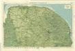
Norfolk, Sheet 15 - Bartholomew's "Half Inch to the Mile Maps" of England & Wales
1 : 126720 Topographic maps Bartholomew, John George John Bartholomew & Co
Sheets 44-45. (Cary's England, Wales, and Scotland).
1 : 360000 Cary, John, ca. 1754-1835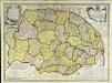
An accurate map of the county of Norfolk
1 Karte : Kupferdruck ; 52 x 70 cm Bowen; Hinton sold by I. Hinton at the Kings Arms in St. Pauls Church yard
Nortfolcia; vernacule Norfolke
1 Karte : Kupferdruck ; 36 x 47 cm Valck; Schenk penes Gerardum Valk et Petrum Schenk


