Maps of Wiltshire

Wiltshire LXVI.SW - OS Six-Inch Map
1 : 10560 Topographic maps Ordnance Survey Ordnance Survey
Wiltshire LXVI.SW - OS Six-Inch Map
1 : 10560 Topographic maps Ordnance Survey Ordnance Survey
Wiltshire LXVI.SW - OS Six-Inch Map
1 : 10560 Topographic maps Ordnance Survey Ordnance Survey
Wiltshire LXVI.9 (includes: Burcombe Without; Wilton) - 25 Inch Map
1 : 2500 Topographic maps Ordnance Survey Ordnance Survey
Wiltshire LXVI.9 (includes: Burcombe Without; Wilton) - 25 Inch Map
1 : 2500 Topographic maps Ordnance Survey Ordnance Survey
Wiltshire LXVI.9 (includes: Burcombe Without; Wilton) - 25 Inch Map
1 : 2500 Topographic maps Ordnance Survey Ordnance Survey
Wiltshire LXVI.9 (includes: Burcombe Without; Wilton) - 25 Inch Map
1 : 2500 Topographic maps Ordnance Survey Ordnance Survey
Wiltshire LXVI.10 (includes: Netherhampton; New Sarum; Quidhampton; Wilton) - 25 Inch Map
1 : 2500 Topographic maps Ordnance Survey Ordnance Survey
Wiltshire LXVI.10 (includes: Netherhampton; New Sarum; Quidhampton; Wilton) - 25 Inch Map
1 : 2500 Topographic maps Ordnance Survey Ordnance Survey
Wiltshire LXVI.10 (includes: Netherhampton; New Sarum; Quidhampton; Wilton) - 25 Inch Map
1 : 2500 Topographic maps Ordnance Survey Ordnance Survey
Wiltshire LXVI.10 (includes: Netherhampton; New Sarum; Quidhampton; Wilton) - 25 Inch Map
1 : 2500 Topographic maps Ordnance Survey Ordnance Survey
Wiltshire LXVI.13 (includes: Bishopstone; Coombe Bissett; Netherhampton; Stratford Tony; Wilton) - 25 Inch Map
1 : 2500 Topographic maps Ordnance Survey Ordnance Survey
Wiltshire LXVI.13 (includes: Bishopstone; Coombe Bissett; Netherhampton; Stratford Tony; Wilton) - 25 Inch Map
1 : 2500 Topographic maps Ordnance Survey Ordnance Survey
Wiltshire LXVI.13 (includes: Bishopstone; Coombe Bissett; Netherhampton; Stratford Tony; Wilton) - 25 Inch Map
1 : 2500 Topographic maps Ordnance Survey Ordnance Survey
Wiltshire LXVI.13 (includes: Bishopstone; Coombe Bissett; Netherhampton; Stratford Tony; Wilton) - 25 Inch Map
1 : 2500 Topographic maps Ordnance Survey Ordnance Survey
Wiltshire LXVI.14 (includes: Netherhampton; Quidhampton; Wilton) - 25 Inch Map
1 : 2500 Topographic maps Ordnance Survey Ordnance Survey
Wiltshire LXVI.14 (includes: Netherhampton; Quidhampton; Wilton) - 25 Inch Map
1 : 2500 Topographic maps Ordnance Survey Ordnance Survey
Wiltshire LXVI.14 (includes: Netherhampton; Quidhampton; Wilton) - 25 Inch Map
1 : 2500 Topographic maps Ordnance Survey Ordnance Survey
Wiltshire LXVI.14 (includes: Netherhampton; Quidhampton; Wilton) - 25 Inch Map
1 : 2500 Topographic maps Ordnance Survey Ordnance Survey
Wiltshire LXVI.14 (includes: Netherhampton; Quidhampton; Wilton) - 25 Inch Map
1 : 2500 Topographic maps Ordnance Survey Ordnance Survey
An exact plan of the gardens and park at Wilton the seat of Henry Earl of Pembroke
1 : 1800 Rocque, John Pembroke, Henry Herbert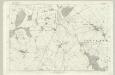
Wiltshire LXVI - OS Six-Inch Map
1 : 10560 Topographic maps Ordnance Survey Ordnance Survey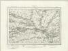
Salisbury (Outline) - OS One-Inch Revised New Series
1 : 63360 Topographic maps Ordnance Survey Ordnance Survey
Salisbury (Hills) - OS One-Inch Revised New Series
1 : 63360 Topographic maps Ordnance Survey Ordnance Survey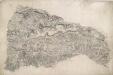
Berwick St. John
Small red crosses at Baverstoke, at the top centre, and Et Knoyle, at the top left,mark observation points used by the surveyor to plot topographical details and measure distances. The draughtsman has faithfully recorded the relative relief of the hills and indicated areas of woodland, using various shades of green to distinguish woods from grassland. The ancient circular earthworks of Chiselbury are marked by concentric rings on White Sheet Hill, in the centre of the drawing.
Dorset Shire, 3
2 Blätter : 109 x 45 cm s.n.
Salisbury - OS One-Inch Map
1 : 63360 Topographic maps Ordnance Survey Ordnance Survey
Cary's Improved Map of England and Wales
Cary, George, & Cary, John London : G. & J. Cary
An improved map of Wilt Shire
1 Karte : Kupferdruck ; 52 x 68 cm Bowen; Tinney sold by I. Tinney at the Golden Lion in Fleet street


