Maps of Northumberland

Northumberland LIV.NW - OS Six-Inch Map
1 : 10560 Topographic maps Ordnance Survey Ordnance Survey
Northumberland (New Series) L.10 (includes: Brinkburn High Ward; Hesleyhurst; Raw; Wingates) - 25 Inch Map
1 : 2500 Topographic maps Ordnance Survey Ordnance Survey
Northumberland (Old Series) LIV.2 (includes: Brinkburn High Ward; Brinkburn Low Ward; Raw; Riddells Quarter; Todburn; Wingates) - 25 Inch Map
1 : 2500 Topographic maps Ordnance Survey Ordnance Survey
Northumberland (Old Series) LIV.6 (includes: Bigges Quarter; Brinkburn High Ward; Riddells Quarter; Todburn; Wingates) - 25 Inch Map
1 : 2500 Topographic maps Ordnance Survey Ordnance Survey
Northumberland (Old Series) LIV.1 (includes: Brinkburn High Ward; Hesleyhurst; Raw; Wingates) - 25 Inch Map
1 : 2500 Topographic maps Ordnance Survey Ordnance Survey
Northumberland (Old Series) LIV.5 (includes: Hesleyhurst; Wingates) - 25 Inch Map
1 : 2500 Topographic maps Ordnance Survey Ordnance Survey
Northumberland (New Series) L.11 (includes: Bigges Quarter; Brinkburn High Ward; Riddells Quarter; Todburn; Wingates) - 25 Inch Map
1 : 2500 Topographic maps Ordnance Survey Ordnance Survey
Northumberland (New Series) L.14 (includes: Wingates) - 25 Inch Map
1 : 2500 Topographic maps Ordnance Survey Ordnance Survey
Northumberland nL.SW - OS Six-Inch Map
1 : 10560 Topographic maps Ordnance Survey Ordnance Survey
Northumberland nL.SW - OS Six-Inch Map
1 : 10560 Topographic maps Ordnance Survey Ordnance Survey
Northumberland nL.SE - OS Six-Inch Map
1 : 10560 Topographic maps Ordnance Survey Ordnance Survey
Northumberland nL.SE - OS Six-Inch Map
1 : 10560 Topographic maps Ordnance Survey Ordnance Survey
Northumberland (New Series) L.15 (includes: Bigges Quarter; Freeholders Quarter; Riddells Quarter; Todburn; Wingates) - 25 Inch Map
1 : 2500 Topographic maps Ordnance Survey Ordnance Survey
Northumberland (New Series) L.6 (includes: Brinkburn High Ward; Hesleyhurst; Raw; Wingates) - 25 Inch Map
1 : 2500 Topographic maps Ordnance Survey Ordnance Survey
Northumberland (New Series) L.7 (includes: Bigges Quarter; Brinkburn High Ward; Brinkburn Low Ward; Longframlington) - 25 Inch Map
1 : 2500 Topographic maps Ordnance Survey Ordnance Survey
Northumberland LIV - OS Six-Inch Map
1 : 10560 Topographic maps Ordnance Survey Ordnance Survey
NZ19 - OS 1:25,000 Provisional Series Map
1 : 25000 Topographic maps Ordnance Survey Ordnance Survey
Northumberland nL.NW - OS Six-Inch Map
1 : 10560 Topographic maps Ordnance Survey Ordnance Survey
Northumberland nL.NE - OS Six-Inch Map
1 : 10560 Topographic maps Ordnance Survey Ordnance Survey
Northumberland (New Series) L.9 (includes: Hesleyhurst; Hollinghill; Wingates) - 25 Inch Map
1 : 2500 Topographic maps Ordnance Survey Ordnance Survey
Northumberland (New Series) L.13 (includes: Coatyards; Hesleyhurst; Hollinghill; Ritton Colt Park; Wingates) - 25 Inch Map
1 : 2500 Topographic maps Ordnance Survey Ordnance Survey
Rothbury (Hills) - OS One-Inch Revised New Series
1 : 63360 Topographic maps Ordnance Survey Ordnance Survey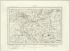
Rothbury (Outline) - OS One-Inch Revised New Series
1 : 63360 Topographic maps Ordnance Survey Ordnance Survey
Morebattle - OS One-Inch map
1 : 63360 Topographic maps Ordnance Survey Ordnance Survey
Morebattle - OS One-Inch map
1 : 63360 Topographic maps Ordnance Survey Ordnance Survey
Morebattle - OS One-Inch map
1 : 63360 Topographic maps Ordnance Survey Ordnance Survey
Hexham - OS One-Inch Map
1 : 63360 Topographic maps Ordnance Survey Ordnance Survey
Newcastle Upon Tyne - OS One-Inch Map
1 : 63360 Topographic maps Ordnance Survey Ordnance Survey
Alnwick - OS One-Inch Map
1 : 63360 Topographic maps Ordnance Survey Ordnance Survey


