Maps of Lorraine

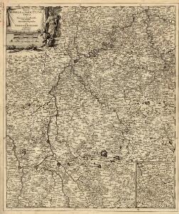
Exactissima Totius Mosellae et Sarae Fluvii Tabula et Minorum in eum influentisim Cum Omnibus Adiacentibus Regionibus
1 : 430000 Mollova mapová sbírka Danckerts, Cornelis Danckerts, Cornelis
Exactissima totius Mosellae et Sarae fluvii tabula
1 : 411000 Lotrinsko (Francie) Danckertsz, Cornelis per Cornelium Danckerts
Western Front from Argonne to Vosges
1 : 250000 First World War map of the Western Front from Argonne to Vosges. 1918. War Office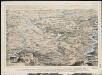
Stannard & Son's, perspective view, of the immediate seat of war & recent battle fields, shewing all the fortifications and natural barriers of the districts lying between the Rhine and Meuse, with the important passes of the Vosges and points d'appui of
1 : 1
Exactissima Lotharingia tam regis Gallorum quam Ducis Caroli
1 : 450000 opera Caroli Allard Amsterdam : gedruckt by Carel Allardt


Sect. 22: Strassburg i/E, uit: Geologische Karte des Deutschen Reichs in 27 Blaettern / [von] Richard Lepsius ; Red. von C. Vogel
1 : 500000 Annotatie: Blad 18 ontbreekt; Een aantal bladen op linnen; Een aantal bladen gereviseerd 1913-1914; Annotatie geografische gegevens: Met schaalstokken o.a. in kilometers; Legenda Carl Vogel 1828-1897 Gotha : Justus Perthes
Elsass-Lothringen, Bayerische Pfalz.
1 : 870000 Andree, Richard
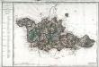
Lotharingia Ducatus Nova descriptio. [Karte], in: Novus atlas absolutissimus, Bd. 4, S. 80.
1 Karte aus Atlas Janssonius Offizin
Les duchez de Lorraine et de Bar les evechez de Metz, Toul, et Verdun
1 Karte : Kupferdruck ; 49 x 57 cm Fer; Bénard chez Benard dans l'isle du Palais sur le quay de l'Orloge a la sphere royale
Les duchez de Lorraine et de Bar les evechez de Metz, Toul, et Verdun
1 Karte : Kupferdruck ; 49 x 57 cm Fer; Starckman chez l'auteur dans l'isle du Palais sur le quay de l'Orloge a la sphere royale

Lotharingia dvcatvs noua descriptio
1 Karte : Kupferdruck ; 41 x 53 cm Janssonius apud Ioannem Ianssonium
Trier et Lutzenburg [Karte], in: Gerardi Mercatoris Atlas, sive, Cosmographicae meditationes de fabrica mundi et fabricati figura, S. 314.
1 Karte aus Atlas Mercator, Gerhard Montanus, Petrus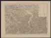
Trier et Lutzenburg [Karte], in: Gerardi Mercatoris et I. Hondii Newer Atlas, oder, Grosses Weltbuch, Bd. 1, S. 404.
1 Karte aus Atlas Mercator, Gerhard und Hondius, Jodocus Jansson, Jan
LVTZENBVRG | DVCATVS
Amsterdami | Apud Guiljelmum et | Ioannem Blaeu.
LVTZENBVRG | DVCATVS
Amsterdami | Apud Guiljelmum et | Ioannem Blaeu.
Les estats, du duc de Lorraine ou sont les duchez de Lorraine et de Bar
1 : 177000 Lotrinsko (Francie) Jaillot, Alexis-Hubert S. Taillot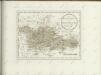
Département de la Moselle
1 Karte : Kupferdruck ; 48 x 64 cm Houdan au bureau de l'atlas national rue de la Harpe no. 26, et au dépôt de cet atlas rue de la Monnoye no. 5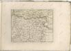

Lotharingia Septentrionalis Loraine vers le Sept.ion [Karte], in: Novus atlas absolutissimus, Bd. 4, S. 85.
1 Karte aus Atlas Janssonius Offizin
Partie du Duché de Luxembourg et de l'Electorat de Treves
1 : 120000 Mollova mapová sbírka Baillieul, Gaspard Baillieul, Gaspard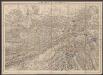
Lotharingia Ducatus [Karte], in: Gerardi Mercatoris Atlas, sive, Cosmographicae meditationes de fabrica mundi et fabricati figura, S. 249.
1 Karte aus Atlas Mercator, Gerhard Montanus, Petrus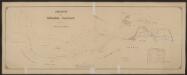
Lotharingia Septentrionalis Loraine vers le Sept.ion [Karte], in: Gerardi Mercatoris et I. Hondii Newer Atlas, oder, Grosses Weltbuch, Bd. 2, S. 41.
1 Karte aus Atlas Mercator, Gerhard und Hondius, Jodocus Jansson, Jan
Lotharingia Ducatus; Vulgo Lorraine. [Karte], in: Le théâtre du monde, ou, Nouvel atlas contenant les chartes et descriptions de tous les païs de la terre, Bd. 2, S. 66.
1 Karte aus Atlas Blaeu, Willem Janszoon und Blaeu, Joan Blaeu, Willem Janszoon
Übersichtskarte für den 15-ten August Abend
1 : 200000 Mety (Francie)

Lotharingia ducatus
1 Karte : Kupferdruck ; 35 x 46 cm Mercator; Hondius Henricus Hondius
Lotharingia ducatus
1 Karte : Kupferdruck ; 35 x 46 cm Mercator; Hondius Jodocus Hondius