Maps of Grand Est

Martis Area et Alea per Tractum Rheni, Mosellae, ac Mosae in qua per plurimos annorum tractus variante eventu saepius certatum, Curatißime designata
1 : 1100000 Mollova mapová sbírka Seutter, Matthäus Seutter, Matthäus
Fluviorum Rheni Mosae ac Mosellae Novissima Exhibitio
1 : 1100000 Mollova mapová sbírka Schenk, Pieter Schenk, Peter I
Fluviorum Rheni Mosae ac Mosellae novissima exhibitio
1 : 1100000 Alsasko (Francie) Schenk, Pieter Petro Schenk
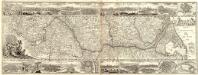
Theatrum Belli Rhenani
1 : 1100000 Mollova mapová sbírka Homann, Johann Baptist Homann, Johann Baptista
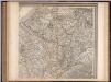
Theatrum belli Rhenani
1 : 1100000 Evropa západní Homann, Johann Baptist Ioan. Baptist Homann
Theatrum belli Rhenani
1 : 1260000 Maas Homann, Johann Baptist Ioan. Baptista Homan


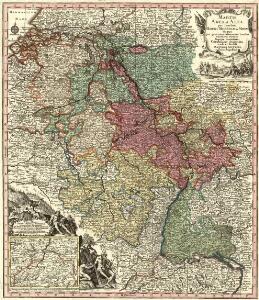
Sedes ac theatrvm bellorvm per plurimos annos in Regionibus Rheni, Mosae ac Mosellae
1 : 920000 Alsasko (Francie) Bodenehr, Gabriel Tobias Conrad Lotter
Sedes ac Theatrvm Bellorvm per plurimos annos in Inferiori et Superiori Germania gestorum accuratissimâ delineatione oculis exhibitum
1 : 1100000 Mollova mapová sbírka Bodenehr, Gabriel Wolff, Jeremias
Der Rhein, die Maass und Mosel mit den anliegenden Ländern des Ober-Chur und Nieder-Rhein. wie auch des Burgundischen Kreises ing. Elsass ünd Lothringen &cc
1 : 902000 Alsasko (Francie) Güssefeld, Franz L. bey denen Homaen[n]ischen Erben
Skizze zur Orientirung ϋber den Feldzug 1795

Schauplatz des dermahligen Krieges, 1793
1 : 2775000 Belgie Stöber, Joseph
Sedes ac Theatrvm Bellorvm per plurimos annos in Regionibus Rheni, Mosae ac Mosellae adjacentibus
Lotter, Tobias Conrad; Bodenehr, Gabriel
Le Cours de la Riviere du Rhein
1 : 1100000 Mollova mapová sbírka Sanson, Guillaume Cordier, Louis Jaillot, Alexis Hubert
Martis Area et Alea per Tractum Rheni, Mosellae, ac Mosae, in qua per plurimos annorum tractus variante eventu saepius certatum, Curatißime designata caelo et studio
1 : 11100000 Mollova mapová sbírka Seutter, Matthäus Seutter, Matthäus
F. Handtke's Special-Karte vom Deutsch-Franz. Kriegsschauplatze
1 : 600000 Belgie Handtke, Friedrich C. Flemming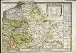
Le royaume de France orientale, dit autrement Austrasie
1 Karte : Kupferdruck ; 39 x 49 cm, Bildgrösse 39 x 56 cm Duval chez l'auteur en l'isle du Palais sur le quay de l'Orloge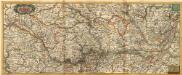
Nova Tractus Totius Rheni T.
1 : 740000 Mollova mapová sbírka Funck, David Funck, David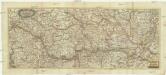
Nova tractus totius Rheni.T
1 : 740000 Evropa západní Funck, David David Funck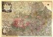
Theatrum Belli Serenissimae Domus Austriacae, Contra Gallos, Confine Limitibus Sacri Romani Imperii et Belgii
1 : 400000 Mollova mapová sbírka Oettinger, Johann Friedrich Lotter, Tobias Conrad Seutter, Matthäus
Tabula geographica qua pars septentrionalis sive Inferior Rheni, Mosae, et Mosellae, maximaeque partes Visurgis, Moeni, Amasi, Scaldis, Isalae, et alia in eosdem inluentia flumina, nec non provinciae Germaniae inferioris, Westphaliae, Hassiae, archiepiscopatus et electoratus Coloniensis ac Trevirensis, cum partibus Moguntini, et Palatinus Rheni, et aliae regiones adjacentes
1 : 1000000 accuratissime ostenduntur per Nicolaum Visscher Amst. Bat. Amst[elodami] Bat[avorum] : nunc apud Petrum Schenk Jun.
France
Frankreich. Upper right sheet
1 : 1200000 Geographisches Institut (Weimar, Germany)
Totius Rheni tractus
1 : 870000 Mollova mapová sbírka Valk, Gerhard Valck, Gerard
Carte de la France, 2
2 Blätter : mehrfarbig ; 71 x 83 cm de Belleyme
Totius Rheni, ab eius capitibus ad oceanum usque Germanicum in quem se exonerat novißima descriptio
1 : 1025000 Belgie Hondius, Henricus Keere, Pieter van den sumptibus Henrici Hondii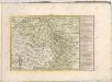
Totius Fluminis Rheni Accvratissima Delineatio Das ist
1 : 930000 Mollova mapová sbírka Hipschmann, Sigmund Gabriel