Maps of Grand Est

France

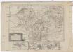
Theatrum Belli Serenissimae Domus Austriacae
1 : 410000 Mollova mapová sbírka Oettinger, Johann Friedrich Seutter, Matthäus
Theatrum Belli Serenissimae Domus Austriacae
1 : 410000 Mollova mapová sbírka Oettinger, Johann Friedrich Seutter, Matthäus
Theatrum Belli Serenissimae Domus Austriacae
1 : 410000 Mollova mapová sbírka Oettinger, Johann Friedrich Seutter, Matthäus
Theatrum Belli Serenissimae Domus Austriacae
1 : 410000 Mollova mapová sbírka Oettinger, Johann Friedrich Seutter, Matthäus
Theatrum Belli Serenissimae Domus Austriacae
1 : 410000 Mollova mapová sbírka Oettinger, Johann Friedrich Seutter, Matthäus
Theatrum Belli Serenissimae Domus Austriacae
1 : 410000 Mollova mapová sbírka Oettinger, Johann Friedrich Seutter, Matthäus
Skizze zur Orientirung ϋber den Feldzug 1795

Kriegsschauplatz oder Graenzkarte zwischen Deutschland und Franckreich
1 Karte auf 2 Blättern : Kupferdruck ; 61 x 56 cm Walch zu haben bei Ioh. Walch im eignem Kunstverlag
Sedes ac Theatrvm Bellorvm per plurimos annos in Inferiori et Superiori Germania gestorum accuratissimâ delineatione oculis exhibitum
1 : 1100000 Mollova mapová sbírka Bodenehr, Gabriel Wolff, Jeremias
Schauplatz des dermahligen Krieges, 1793
1 : 2775000 Belgie Stöber, Joseph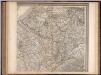
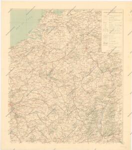
Frankreich. Upper right sheet
1 : 1200000 Geographisches Institut (Weimar, Germany)
Carte des peuples riverains du Rhin au temps d’Auguste et de ses successeurs immédiats
Mitteleuropa Rhein-Gebiet ethnische Gruppe Germanen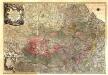
Theatrum Belli Serenissimae Domus Austriacae, Contra Gallos, Confine Limitibus Sacri Romani Imperii et Belgii
1 : 400000 Mollova mapová sbírka Oettinger, Johann Friedrich Lotter, Tobias Conrad Seutter, Matthäus
Zu den Feldzügen 1708 in den Niederlanden und am Rhein
Lille (Francie) Coxe, William K.k. Generalstabes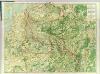
Map Western Front.
1 : 633600 C.S. Hammond & Company
F. Handtke's Special-Karte vom Deutsch-Franz. Kriegsschauplatze
1 : 600000 Belgie Handtke, Friedrich C. Flemming
Belli ab obitu Caroli VI. Imperatoris usqve ad pacem Dresdae d. 25. Dec. MDCCXLV
1 : 1300000 Mollova mapová sbírka Kraus, Lorenz Jacob Homann, Johann Baptista - dědici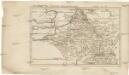
Belgica oder Nieder Teutschland
Belgie Baumgarten, Siegmund Jakob Johann Justinus Gebauer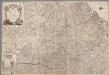
Carte geographique representant le cours entier du Rhin, de la Moselle, de la Meuse et de l'Escaut avec les pays confins specialement l'etat actuel de toutes les possessions de la Maison de l'Autriche dans les Pays Bas et une grande partie de la France / par Matthieu Albert et George Frederic Lotter = Cabinetskarte welche den ganzen Lauff des Rheins, der Mosel, der Maas und Schelde nebst den angraenzenden Laendern vorzüglich alle gegenwaertige Besi[t]zungen des Hauses Oesterreich und einen grossen Theil von Frankreich vorstellt
1 : 400000 titelvariant: Cabinetskarte welche den ganzen Lauff des Rheins, der Mosel, der Maas und Schelde nebst den angraenzenden Laendern vorzüglich alle gegenwaertige Besitzungen des Hauses Oesterreich und einen grossen Theil von Frankreich vorstellt; Annotatie: Titel in handschrift op verso: Cabinetskarte Rhein, Mosel, Maas, Schelde; Annotatie geografische gegevens: West boven Lotter, Mattäus Albrecht; Lotter, Georg Friedrich Augsbourg : Lotter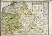
Le royaume de France orientale, dit autrement Austrasie
1 Karte : Kupferdruck ; 39 x 49 cm, Bildgrösse 39 x 56 cm Duval chez l'auteur en l'isle du Palais sur le quay de l'Orloge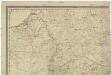
[Západní Evropa]
Belgie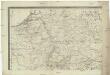
[Západní Evropa]
Belgie
Sedes ac Theatrvm Bellorvm per plurimos annos in Regionibus Rheni, Mosae ac Mosellae adjacentibus
Lotter, Tobias Conrad; Bodenehr, Gabriel
Le Cours du Rhein
1 : 1100000 Mollova mapová sbírka Fer, Nicolas de Fer, Nicolas de
Carte de la France, 2
2 Blätter : mehrfarbig ; 71 x 83 cm de Belleyme
Sedes ac theatrvm bellorvm per plurimos annos in Regionibus Rheni, Mosae ac Mosellae
1 : 920000 Alsasko (Francie) Bodenehr, Gabriel Tobias Conrad Lotter
67-68. North-East France, Belgium, Luxemburg. The World Atlas.
1 : 1250000 USSR (Union of Soviet Socialist Republics).
Martis Area et Alea per Tractum Rheni, Mosellae, ac Mosae in qua per plurimos annorum tractus variante eventu saepius certatum, Curatißime designata
1 : 1100000 Mollova mapová sbírka Seutter, Matthäus Seutter, Matthäus