Maps of Grisons

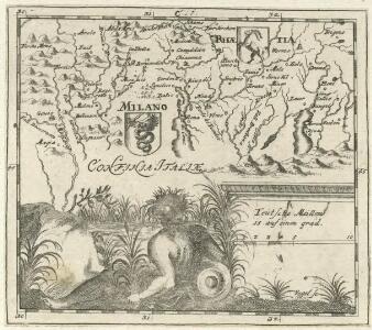
Milano. Rhaetia
Mollova mapová sbírka Hoffmann, Johannes Hoffmann, Johann
Carte du canton d'Uri des Grisons de la Valteline de comtez de Bormio de Cleve &c
1 Blatt : Covens et Mortier
Nova Helvetiae tabula geographica, 4
1 Blatt : Pieter Schenk
Nova Helvetiae tabula geographica, 4
1 Blatt : Johann Jakob Scheuchzer
Alpinae seu Foederatae Rhaetiae Subditarumque ei Terrarum nova descriptio. [Karte], in: Gerardi Mercatoris et I. Hondii Newer Atlas, oder, Grosses Weltbuch, Bd. 1, S. 268.
1 Karte aus Atlas Mercator, Gerhard und Hondius, Jodocus Jansson, Jan
Alpinae seu Foederatae Rhaetiae Subditarumque ei Terrarum nova descriptio. [Karte], in: Novus Atlas, das ist, Weltbeschreibung, Bd. 1, S. 248.
1 Karte aus Atlas Blaeu, Joan Blaeu, Willem Janszoon
Alpinae seu Foederatae Rhaetiae Subditarumque ei Terrarum nova descriptio. [Karte], in: Novus atlas absolutissimus, Bd. 4, S. 251.
1 Karte aus Atlas Janssonius Offizin
Alpinae seu Foederatae Rhaetiae Subditarumque ei Terrarum nova descriptio. [Karte], in: Le théâtre du monde, ou, Nouvel atlas contenant les chartes et descriptions de tous les païs de la terre, Bd. 1, S. 279.
1 Karte aus Atlas Blaeu, Willem Janszoon und Blaeu, Joan Blaeu, Willem Janszoon
Carte du phénomène erratique et des anciens glaciers du versant nord des Alpes Suisses et de la chaîne du Mont-Blanc
1 : 250000 Südost-Blatt Favre, Alphonse Imp. par l'Etabl. topogr. de Wurster, Randegger et Cie.
Alpinæ seu Foederatæ | RHAETIAE | SUBDITARUMQUE | ei Terrarum nova | descriptio
Auctoribus | Fortunato Sprechero à Berneck, Eq. aur. & I.V.D. Ret. | Ac PHIL. CLUVERIO. Evert Sijmons Z. | Hamers Veldt sculp. Amstelodami | Apud Judocum | Hondium
Le canton de Ury, les Ligues Grise et de la Maison-Dieu, la Valteline, les comtés de Chiavene et de Bormio, dans les Grisons, les trois balliages de Bellinzone, les quatre gouvernements en Italie de Lugano, Locarno, Mendrisio et Valmadia
1 Karte : Kupferdruck ; 47 x 65 cm Jaillot Alexis-Hubert Jaillot
Offizielle Postkarte der Schweiz mit Angabe der Telegraphenbureaux & Eisenbahnen
1 : 250000 1 Karte in 4 Teilen auf 4 Blättern herausgegeben von der Schweizerischen Postverwaltung; unter Aufsicht des eidg. topogr. Bureau bearbeitet Schweizerische Postverwaltung, [Bern]
Karte der Schweiz
1 : 250000 1 Karte auf 4 Bl. [Verlag nicht ermittelbar], [Erscheinungsort nicht ermittelbar]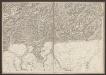
Officielle Eisenbahn-Karte der Schweiz
1 : 250000 Südost-Blatt Müllhaupt, Hans Heinrich [Eidg. Stabsbureau]
Reisekarte von Graubünden, Schweiz
1 : 300000 Graubünden (Švýcarsko) Direktion der Rhätischen Bahn
Karte der Schweiz in IV Blättern
1 : 250000 4 Karten nach dem topographischen Atlasse des eidgenössischen Generalstabes reduziert unter der Direction des Herrn Generals G.H. Dufour ; gest. von H. Müllhaupt Eidg. Stabsbureau, [Bern]
Rhaetia Foederata cum Confinibus et Subditis suis Valle Telina, Comitatu Clavennensi et Bormiensi, recenter et accuratißimé delineata
1 : 320000 Mollova mapová sbírka Walser, Gabriel Silbereisen, Andreas Seutter, Matthäus
<<Der>> Canton Graubünden
1 : 470000 1 Karte R. am Stein delin. ; Scheurmann sculp. [Orell Füssli], [Zürich]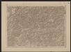
Officielle Eisenbahn-Karte der Schweiz
1 : 250000 Südost-Blatt [s.n.]
Alpinae seu Foederatae Rhaetiae Subditarumque ei Terrarum nova descriptio. [Karte], in: Theatrum orbis terrarum, sive, Atlas novus, Bd. 1, S. 303.
1 Karte aus Atlas Blaeu, Joan Blaeu, Willem Janszoon
[Kaart], uit: Reisekarte von Graubünden, Schweiz / Kümmerly & Frey
1 : 300000 Kümmerly + Frey, Bern Chur : Direktion der Rhätischen Bahn
Karte des Kantons Graubundten [i.e. Graubünden]
1 : 250000 1 Karte J. Wurster u. Comp., Winterthur

Karte des Kantons Graubünden
1 : 250000 1 Karte Joh. Wurster & Comp., Winterthur
<<Der>> Canton Graubünden
1 : 470000 1 Karte R. am Stein delin. ; Scheurmann sculp. [Orell Füssli], [Zürich]
Schulwandkarte zur Geschichte der Schweiz
1 : 180000 1 Karte auf 6 Bl. bearbeitet v. W. Oechsli u. A. Baldamus ; gezeichnet von Ed. Gaebler Kartograph. Verlagsanstalt von Georg Lang, Leipzig
Karte des Kantons Graubünden
1 : 250000 Mengold, G.W. ; Held, Leonz Verlag der Leonhard Hitz'schen Buchhandlung
Karte des Kantons Graubünden
1 : 600000 1 Karte Wurster, Randegger & Co. Kellerberger'sche Buchhandlung (J.M. Albin), Chur