Maps of Grisons

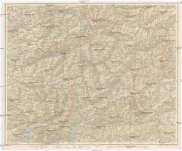
Reisekarte von Graubünden, Schweiz
1 : 300000 Graubünden (Švýcarsko) Direktion der Rhätischen Bahn
Karte des Kantons Graubundten [i.e. Graubünden]
1 : 250000 1 Karte J. Wurster u. Comp., Winterthur
[Kaart], uit: Reisekarte von Graubünden, Schweiz / Kümmerly & Frey
1 : 300000 Kümmerly + Frey, Bern Chur : Direktion der Rhätischen Bahn
Rhaetia Foederata cum Confinibus et Subditis suis Valle Telina, Comitatu Clavennensi et Bormiensi, recenter et accuratißimé delineata
1 : 320000 Mollova mapová sbírka Walser, Gabriel Silbereisen, Andreas Seutter, Matthäus
Karte des Kantons Graubünden
1 : 250000 1 Karte Joh. Wurster & Comp., Winterthur
<<Der>> Canton Graubünden
1 : 470000 1 Karte R. am Stein delin. ; Scheurmann sculp. [Orell Füssli], [Zürich]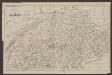
Alpinae seu Foederatae Rhaetiae Subditarumque ei Terrarum nova descriptio. [Karte], in: Gerardi Mercatoris et I. Hondii Newer Atlas, oder, Grosses Weltbuch, Bd. 1, S. 268.
1 Karte aus Atlas Mercator, Gerhard und Hondius, Jodocus Jansson, Jan
<<Der>> Canton Graubünden
1 : 470000 1 Karte R. am Stein delin. ; Scheurmann sculp. [Orell Füssli], [Zürich]
Alpinae seu Foederatae Rhaetiae Subditarumque ei Terrarum nova descriptio. [Karte], in: Novus Atlas, das ist, Weltbeschreibung, Bd. 1, S. 248.
1 Karte aus Atlas Blaeu, Joan Blaeu, Willem Janszoon
Karte des Kantons Graubünden
1 : 600000 1 Karte Wurster, Randegger & Co. Kellerberger'sche Buchhandlung (J.M. Albin), Chur
<<Der>> Canton Graubünden
1 : 470000 1 Karte R. am Stein delin. ; Scheurmann sculp. [Orell Füssli & Cp.], [Zürich]
Karte des Kantons Graubündten [i.e. Graubünden]
1 : 250000 1 Karte Topogr. Anstalt Winterthur, J. Schlumpf Geographisches Institut J. Meier, Zürich
Karte des Kantons Graubünden
1 : 250000 Mengold, G.W. ; Held, Leonz Verlag der Leonhard Hitz'schen Buchhandlung
Alpinae seu Foederatae Rhaetiae Subditarumque ei Terrarum nova descriptio. [Karte], in: Novus atlas absolutissimus, Bd. 4, S. 251.
1 Karte aus Atlas Janssonius Offizin
<<Der>> Canton Graubünden
1 : 470000 1 Karte R. am Stein delin. ; Scheurmann sculp. [Orell Füssli & Cp.], [Zürich]
Alpinæ seu Foederatæ | RHAETIAE | SUBDITARUMQUE | ei Terrarum nova | descriptio
Auctoribus | Fortunato Sprechero à Berneck, Eq. aur. & I.V.D. Ret. | Ac PHIL. CLUVERIO. Evert Sijmons Z. | Hamers Veldt sculp. Amstelodami | Apud Judocum | Hondium
Alpinae seu Foederatae Rhaetiae Subditarumque ei Terrarum nova descriptio. [Karte], in: Theatrum orbis terrarum, sive, Atlas novus, Bd. 1, S. 303.
1 Karte aus Atlas Blaeu, Joan Blaeu, Willem Janszoon
Atlas novus Reipublicae Helveticae
1 Atlas ([40] Bl., 97 S.) bey Orell, Gessner und Compagnie, Zürich
<<Der>> Canton Graubünden
1 : 470000 1 Karte R. am Stein delin. ; Scheurmann sculp. [Orell Füssli & Cp.], [Zürich]
Karte des Kantons Graubünden
1 : 250000 Mengold, G.W. Verlag der Leonhard Hitz'schen Buchhandlung
Alpinæ seu fœderatæ Rhaetiae subditarumqve ei terrarum nova descriptio
1 Karte : Kupferdruck ; 39 x 52 cm Cluverius; Visscher; Sprecher von Bernegg Claes Jansz. Visscher
Alpinae seu Foederatae Rhaetiae Subditarumque ei Terrarum nova descriptio. [Karte], in: Le théâtre du monde, ou, Nouvel atlas contenant les chartes et descriptions de tous les païs de la terre, Bd. 1, S. 279.
1 Karte aus Atlas Blaeu, Willem Janszoon und Blaeu, Joan Blaeu, Willem Janszoon
<<Der>> Kanton Graubünden
1 : 460000 1 Karte gez. von Rud. Gross Verlag von Ch. Beÿel, Zürich
Atlas de la Suisse
1 : 450000 1 Atlas (19 Bl.) dessiné par MM. H. Keller, Scheurmann, Pfyffer d'Altishofen, Osterwald, etc. ; gravé par M. Scheurmann Orell Füssli & Co., Zürich
Graubünden
1 : 1450000 [Stumme Kartenskizzen der ganzen Schweiz und der einzelnen Kantone zu Unterrichtszwecken] Schulbuchhandlung Antenen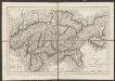
Canton Graubünden
1 : 470000 Am Stein, Rudolf ; Scheuermann, Johann Jakob [Orell Füssli]
Rhætia fœderata cum confiniis et subditis suis Valle Telina, comitatu Clavennensi et Bormiensi
1 Karte : Kupferdruck ; 45 x 55 cm Walser edentibus Homannianis Heredibus
Alpinæ seu fœderatæ Rhaetiae subditarumqve ei terrarum nova descriptio
1 Karte : Kupferdruck ; 40 x 53 cm Cluverius; Geelkercken; Holstein; Sprecher von Bernegg s.n.
Alpinae seu foederatae Rhaetiae subditarumque ei terrarum nova descriptio
1 : 385000 Raetie Sprecher von Bernegg, Fortunat Blaeu, Willem Janszoon Guiljelmus Blaeuw